San Antonio River Tunnel – Protecting Downtown San Antonio

Written by:

Posted on:

Categories:

Share:

Facebook
Twitter
LinkedIn
Email

Get The Latest:

Join our print or digital newsletter to be informed about the agency’s many projects and other news.

Construction of the San Antonio River Tunnel taking place

As part of our commitment to safe, clean, enjoyable creeks and rivers, the San Antonio River Authority (River Authority) employs a comprehensive approach to flood mitigation. Man-made structures, such as dams and tunnels, are designed to manage the flow of flood water in order to protect life and property.

For more than twenty years, the San Antonio River Tunnel has helped protect downtown San Antonio from damaging floods which in turn has saved hundreds of millions of dollars in property damage. Learn more about this flood mitigation project and the River Authority’s role in making this project a reality.

What led to the construction of the San Antonio River Tunnel?

The San Antonio River Basin has a long history of flooding. In 1954, following a series a devastating floods in prior decades, including a flood in 1946 that caused significant damage to the community and took the lives of four people, the U.S. Congress authorized the San Antonio River Channel Improvements Project (SACIP) allowing Bexar County and the River Authority to enter into a partnership with the U.S. Army Corps of Engineers to improve flood control along 31 miles of the San Antonio River and its tributaries. This involved realignment and channelization of the river system to move flood waters quickly away from urbanized areas. Construction began on the SACIP in 1958.

By the 1980s, all the SACIP channelization work was completed, but there was still a need for further flood protection for downtown San Antonio. Work on the SACIP continued with construction on the San Pedro Creek Tunnel was started in the late 1980s and completed in 1991. The San Antonio River Tunnel project, which was a larger and more complex project, began in 1993 and was completed in December 1997 at an estimated cost of $111 million. The River Authority administered both tunnel projects in partnership with the U.S. Army Corps of Engineers. Bexar County and the City of San Antonio were also partners in the projects.

On October 17-18, 1998, south central Texas experienced record-breaking rainfall, and both the San Pedro Creek and the San Antonio River tunnels performed as designed, sparing downtown San Antonio from a devastating flood. In 1999, the San Antonio River Tunnel project won the State of Texas Outstanding Civil Engineering Achievement Award from the American Society of Civil Engineers; it also received a national-level Award of Merit. A year later, it was one of four projects to receive the Federal Design Achievement Award from the National Endowment for the Arts (NEA), as well as an achievement award from the American Society of Civil Engineers in recognition of the San Antonio River Tunnel Inlet Site.

Where is the San Antonio River Tunnel located?

San Antonio River Tunnel Inlet

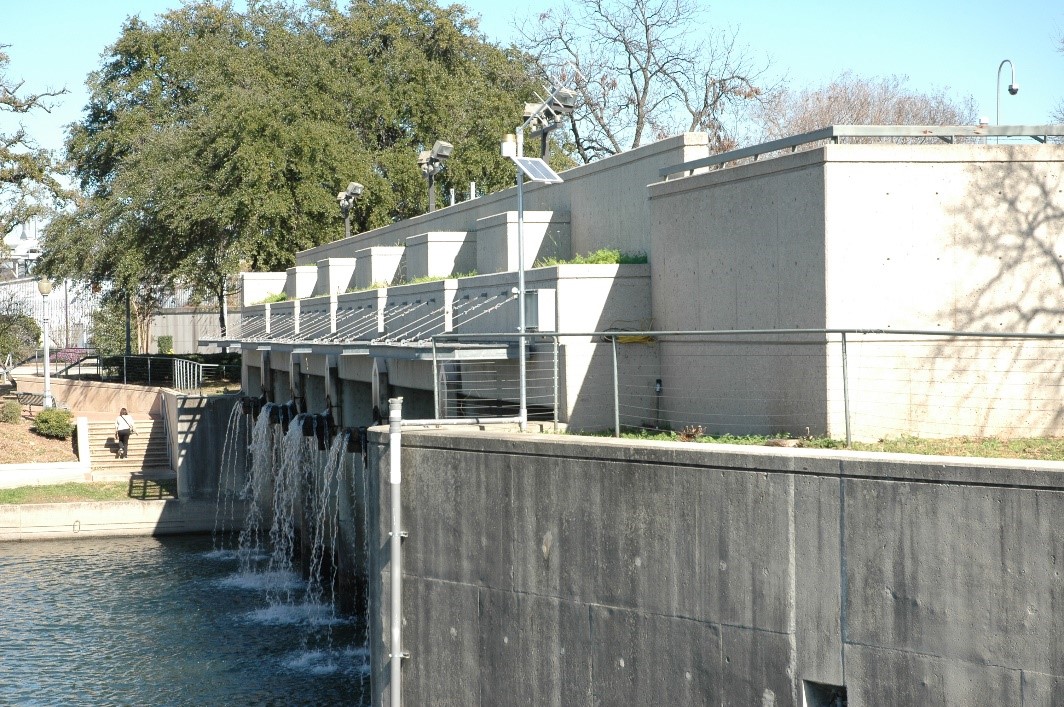
The tunnel intake shaft is located between West Josephine Street and Highway 281 North and is now part of the Museum Reach San Antonio River Walk segment. The contractor, BRH Garver Company, constructed the Inlet structure to direct water from the San Antonio River into the tunnel and it consists of a 120-foot-long intake which includes rotating racks to collect trash before it can enter the tunnel. The River Authority provided landscaping, an aerating water feature, disinfection, and recirculation pumps to recirculate water from the tunnel and into the river to supplement flow during dry periods. This helps keep the River Walk flowing for the enjoyment of visitors and locals.

San Antonio River Tunnel Outlet

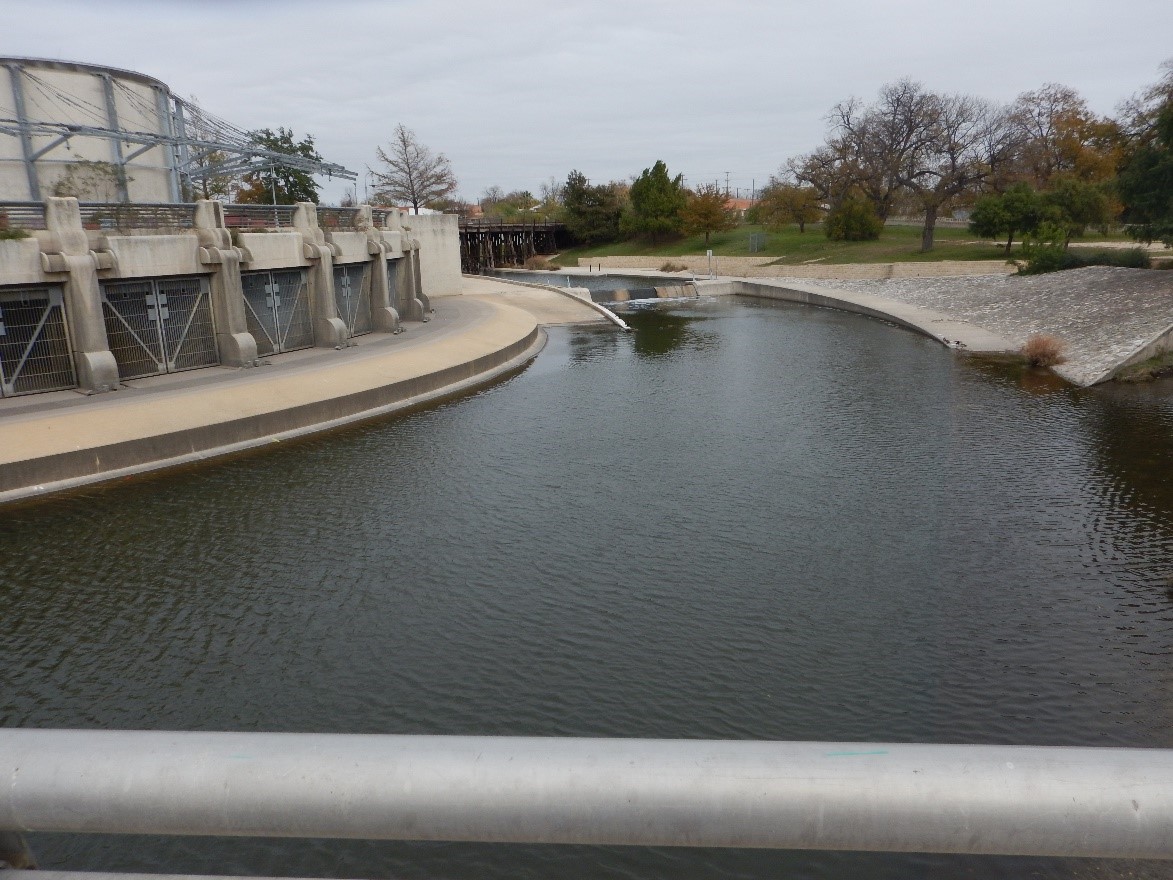
The tunnel outlet structure is located just north of Lone Star Boulevard on the west bank of the river along the Mission Reach San Antonio River Walk segment. The Martin K. Eby Company constructed the tunnel outlet structure which directs discharge from the tunnel shaft into the San Antonio River. The outlet structure measures 230 feet across the front and water features are included to enhance the appearance of the outlet structure.

How does the tunnel work?

San Antonio River Tunnel illustration on how the structure functions

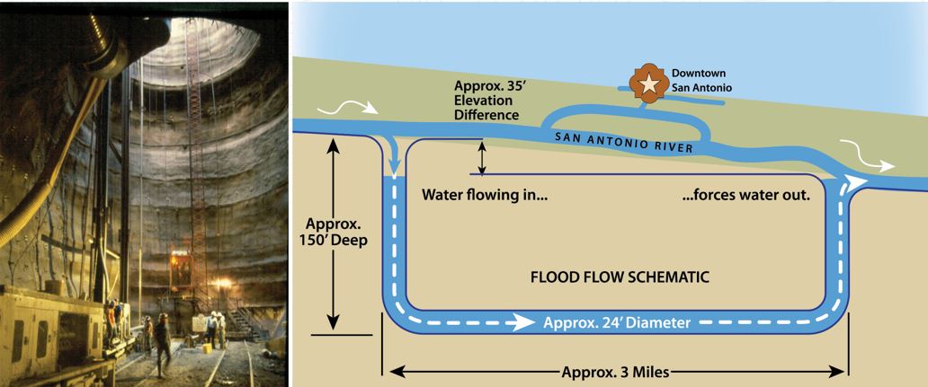
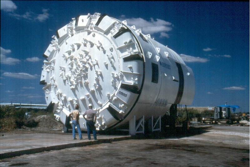
The tunnel was excavated by the Ohbayashi Corporation, and the 3-mile long tunnel uses gravity to bypass floodwaters under downtown San Antonio. The inlet structure is about 30 feet higher than the outlet structure, which allows gravity to push water through the tunnel and out of the outlet structure safely into the river channel of the Mission Reach segment. During flood events, the tunnel can move up to 3 million gallons of water per minute!

Following construction of the project, the River Authority and U.S. Army Corps of Engineers turned the tunnel over to the City of San Antonio to operate and maintain the tunnel.

We hope you’ve enjoyed learning about this significant flood mitigation project! The next time you’re visiting the San Antonio River Walk, keep an eye out for the tunnel inlet and outlet structures and share this knowledge with your friends and loved ones.

Related Articles

Alerts

Stay Weather‑Aware This Weekend

Stay Weather‑Aware This Weekend

Rain is expected across the region this weekend, which may result in high water on roads and temporary closures at low water crossings.

Before heading out, residents are encouraged to check SARiverFlood.org or their local county flood website for real‑time roadway conditions:

These sites provide up‑to‑date information from flood‑monitoring sensors across the region. Real‑time updates are available 24/7 to help you stay informed as conditions change.

Please use caution when traveling and plan routes accordingly.

Restroom Closure Notice – Camino Coahuilteca (Acequia Park Trail)


Restroom Closure Notice – Camino Coahuilteca (Acequia Park Trail)

The restrooms at Camino Coahuilteca along the Acequia Park Trail will be temporarily closed on Thursday, April 16 due to parking lot improvements in the area.

We encourage visitors to plan accordingly and utilize nearby facilities during this time.

We appreciate your patience as we complete this work to enhance the park experience.


Museum Reach – Oxbow Trail Closure Notice

The Oxbow Trail along the Museum Reach will be temporarily closed beginning Monday, April 13 through May 1 to accommodate project-related work in the area.

For public safety, access to this section of the trail will be restricted during this time. Visitors are encouraged to plan accordingly and use alternate routes.

Wayfinding signage and trail closure notices will be posted at designated locations to help guide trail users around the closure.

We appreciate your patience and understanding as we complete this work to help maintain safe and enjoyable trail conditions.

San Pedro Creek Culture Park

The east bank trail along San Pedro Creek will be temporarily closed between the upper trail at Cameron St. and the lower trail at two access points.

Closure details:

  • The first closure will impact the connector from the upper trail near West Houston St. to the south lower San Pedro Creek trail.
  • Once work at this location is complete and the trail reopens, construction will shift to the second closure area between the upper and lower trails on the opposite side of the green space.

Please follow posted signage and plan alternate routes. We appreciate your patience as this work is completed.

Closed areas around San Pedro Creek Culture Park

The Brackenridge Trail

Trail Lighting Notice – Brackenridge Park Trail

Due to an electrical issue, lighting is currently out along the north portion of the trail, from the Josephine Street inlet to just past Highway 281 within the Brackenridge Park Trail. Our team is actively working to correct the issue and expects repairs to be completed by the end of business tomorrow.

We apologize for any inconvenience this may cause and appreciate your patience as we work to restore lighting. Please use caution when traveling through this area, especially during evening hours.

Trail Closure Alert – Calder Alley, San Pedro Creek

Maintenance work will be done in Calder Alley starting Wednesday, September 18, 2025.

  • Trails will remain open during this work.
  • One bench at a time will be temporarily barricaded while improvements are completed.
  • There may be occasional contractor pickups in the area.

We appreciate your patience as we continue to maintain and improve San Pedro Creek for all to enjoy!

SASPAMCO Paddling Trail

The SASPAMCO paddling trail is open from River Crossing Park to Helton Nature Park.
*Please Note: Paddling Trail from Helton Nature Park to HWY 97 is still closed due to blockages. 

SASPAMCO Paddling Trail Temporarily Closed

Staff have removed two large log jams just downstream of Helton Nature Park, keeping the southern portion of the SASPAMCO Paddling Trail temporarily closed. Staff are working to contact adjacent landowners to support a land-based removal solution.

Goliad Paddling Trail Alert

NOTICE: HWY 59 Landing Site Closed

Due to TxDOT construction on the HWY 59 Bridge, the HWY 59 landing site is closed until further notice. However, the Goliad Paddling Trail remains open, and paddlers can still access the river at the Riverdale, Ferry Street, and Goliad State Park landings.

Please plan accordingly and check back for updates.

River Reach Newsletter and Blog Signup

River Reach is offered as a printed, physical mailing to your residence or business. The Blog is a weekly electronic email with news and updates in order to be more environmentally conscious. Please fill out the form below and indicate your preferred method of delivery.

By submitting this form, you are consenting to receive marketing materials from: San Antonio River Authority, 100 East Guenther St., San Antonio, TX, 78204, US. You can revoke your consent to receive emails at any time by using the SafeUnsubscribe® link, found at the bottom of every email. Emails are serviced by Constant Contact. This site is protected by reCAPTCHA and the Google Privacy Policy and Terms of Service apply.