Parks & Trails Notices
Graytown Park Parking Lot Construction Notice
Construction Timeline: April – October 2025 (estimated)
Improvements are coming to Graytown Park! Parking lot construction will begin in April, and we appreciate your patience as we work to enhance the park for all visitors.
Temporary Closures & Impacts:
- Upper parking area, pavilion, and restrooms will be CLOSED during construction. Temporary restroom facilities will be provided.
- Park and river access will be CLOSED Monday–Friday from 8 AM – 5 PM (no access during these hours).
We encourage visitors to plan accordingly and check back for updates as the project progresses. Thank you for your support!
Stay Updated: Follow us on social media for the latest updates.
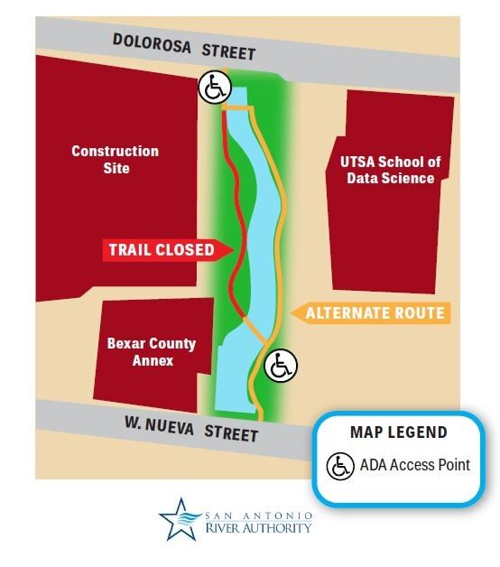
Trail Closure – San Pedro Creek Culture Park
* Trail temporarily closed from 5/1/2025 until 9/1/2025.
Due to adjacent construction work, the San Pedro Creek Trail on the west side of the creek will be closed from the access
point at W. Nueva Street to Dolorosa Street until further notice. Alternate route with ADA access is on the east side of the creek
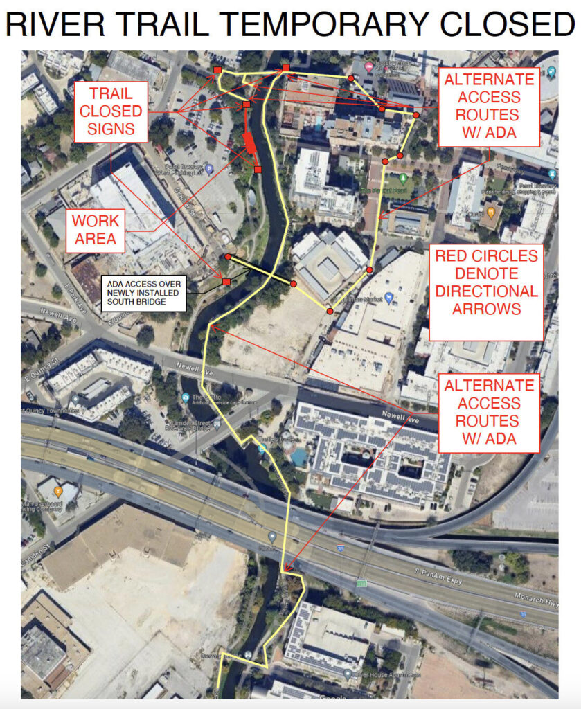
Trail Closure at Myrtle St. Dead End
The trail between Myrtle St. and the newly constructed South Bridge at the Pearl District will be closed due to construction. Alternative pathways around the work area can be seen in the map below. We apologize for the inconvenience

SASPAMCO Paddling Trail
The SASPAMCO paddling trail is open from River Crossing Park to Helton Nature Park.
*Please Note: Paddling Trail from Helton Nature Park to HWY 97 is still closed due to blockages.
SASPAMCO Paddling Trail Temporarily Closed
Staff have removed two large log jams just downstream of Helton Nature Park, keeping the southern portion of the SASPAMCO Paddling Trail temporarily closed. Staff are working to contact adjacent landowners to support a land-based removal solution.
Goliad Paddling Trail Alert
NOTICE: HWY 59 Landing Site Closed
Due to TxDOT construction on the HWY 59 Bridge, the HWY 59 landing site is closed until further notice. However, the Goliad Paddling Trail remains open, and paddlers can still access the river at the Riverdale, Ferry Street, and Goliad State Park landings.
Please plan accordingly and check back for updates.
Bacteria & Flow Conditions
The River Authority tests for bacteria levels at monitoring stations where recreational activity is likely to occur. The River Authority Environmental Sciences Department collects samples at these locations weekly, processes the samples in our laboratory, and the results are displayed here every Friday. Bacteria results are assessed against stream recreation standards and represent levels at the time of sample collection and will vary based on stream flow, rain fall, and other conditions.
This viewer also displays the most recent stream flow reading at United States Geological Survey (USGS) monitoring stations, some of which coincide with stations where bacteria samples are collected.
Please note that bacteria and flow values in this viewer are provisional and may change. Also, per City of San Antonio Code Section 22-87, swimming in the San Antonio River is prohibited within city limits.
