Last Updated on January 30, 2024
As the Authority on flood safety, the top priority for the San Antonio River Authority (River Authority) is public safety through flood risk management. With documented increases in the intensity and destruction of major storms, including Hurricanes Harvey and Ian, the most cost-effective way to prepare and respond to the impact of these storms is to ensure that hydraulic and hydrology information, rainfall data, land use changes, floodplain maps, watershed master plans, and capital improvement master plans stay current.
In that effort, the River Authority is updating floodplain maps in coordination with the Federal Emergency Management Agency (FEMA) to incorporate new data that affects all of Bexar County, located in the San Antonio River Watershed. Individuals and communities use floodplain maps as tools to know which areas will have the highest chance of flooding.
What is a floodplain, and how does it affect me?
FEMA defines a floodplain as any land area susceptible to being inundated by floodwaters from any source. The legally defined floodplains that FEMA designates are used to set rates for flood insurance, and mortgage issuers usually require flood insurance for any property in the floodplain. Cities also set special building regulations for properties inside floodplains. Most importantly, models based on floodplains are used to warn citizens throughout the watershed of impending floods.
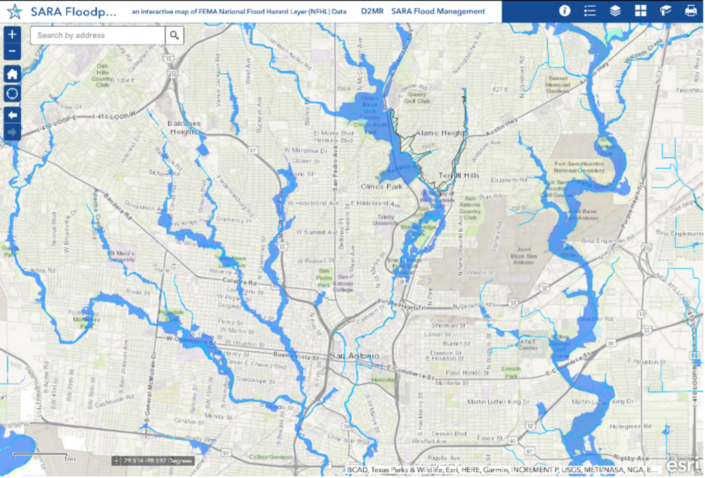
Stay aware of the current floodplain with the River Authority’s Floodplain Viewer.
What data has historically been used in these maps?
The last study of the floodplains in Bexar County used terrain and land use data from around 2004 and rainfall estimates based on data from the 1960s. This was the best available data at that time. Since then, enough information and data have been updated to warrant a refresh of the floodplain maps.
What data is being incorporated now?
Updated information includes:
- the National Oceanic and Atmospheric Administration’s (NOAA) estimates of how much rain will fall in large storms,
- the Texas Natural Resources Information System’s (TNRIS) ground surface elevation data and
- the River Authority’s land use data.
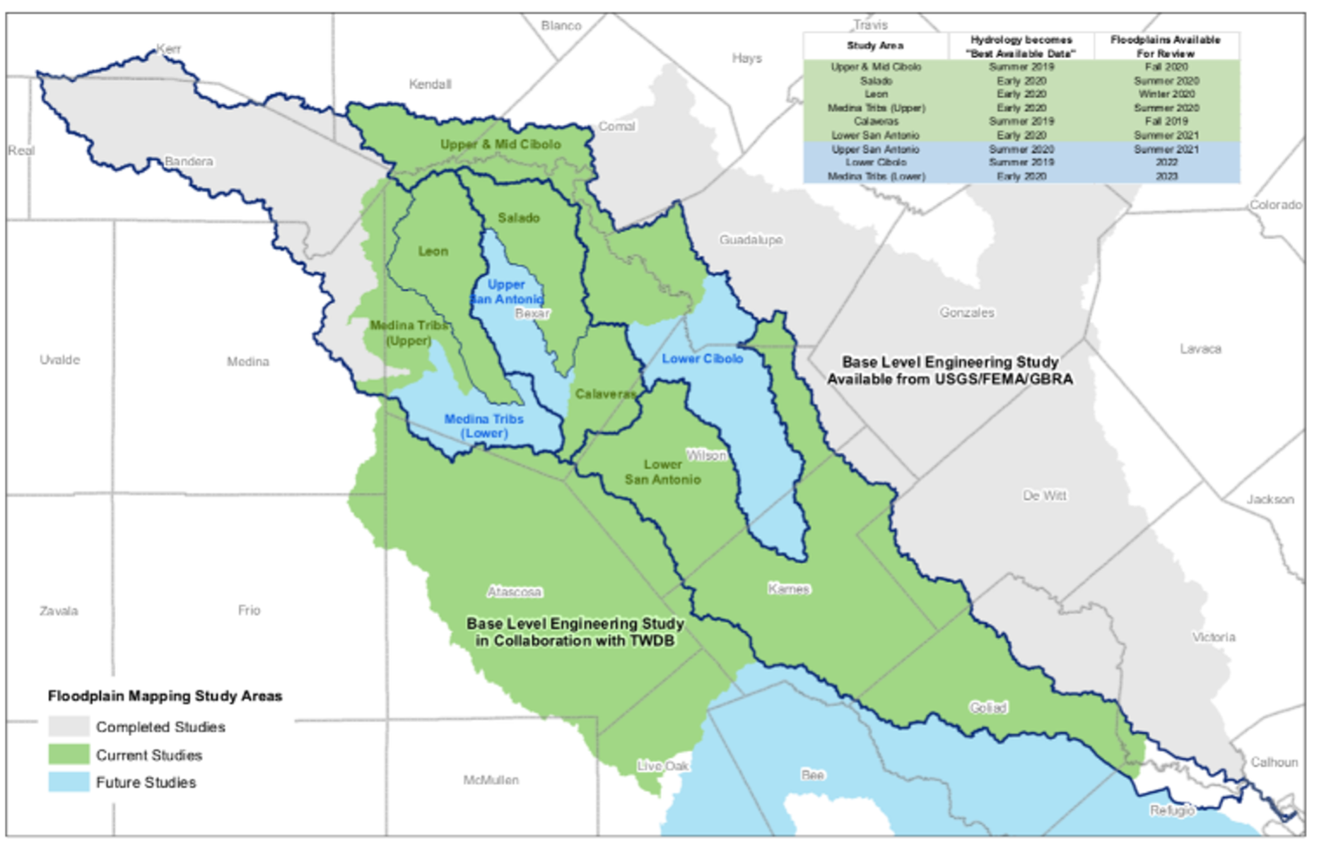
These inputs for the new floodplain mapping study were developed and collected from 2017 to 2019, and engineering studies to develop the draft floodplains have been underway since 2019. As you can see, keeping people and property safe from flooding requires diligence, cooperation, and time. Plus, due to the constantly changing nature of floodplains, it is important to keep the regulatory floodplain maps as current as possible.
Partnerships are key
The River Authority works with various local, county, and federal government partners to make the San Antonio River Basin safer from flooding. The River Authority has interlocal agreements with Bexar County, the City of San Antonio, and 19 suburban cities within Bexar County to maintain the floodplain maps for their jurisdictions. The River Authority is also a Cooperating Technical Partner with FEMA. Through this partnership, FEMA recognizes the River Authority’s crucial floodplain mapping role, performed on behalf of the local communities.
How are these maps maintained?
Day-to-day, the floodplain maps are maintained through Letters of Map Revision. Letters of Map Revision are small-scale floodplain map updates and usually cover small areas like lots or individual neighborhoods. These revisions typically reflect changes to the floodplain that result from construction activity. Less frequently, widespread updates covering an entire county are needed to keep the floodplain mapping data current.
When will these maps become effective?
The River Authority estimates that the new floodplain maps will become formally effective in 18-24 months. The River Authority provides draft floodplains to FEMA, and FEMA continues formalizing the floodplain map panels. FEMA will issue Preliminary Flood Insurance Rate Maps (FIRMS) and then give the public a 90-day appeals and comment period. Effective FIRMS will be published after responses are reviewed and incorporated.
The engineering data is being made available immediately on the River Authority’s Digital Data and Modeling Repository (D2MR) website for use as “Best Available Data.” The D2MR website is a well-known tool used in the development engineering community.
When can the public see the maps?
The River Authority is starting the public engagement process early to provide the community with ample time to review and provide comments on the maps. Starting in January 2023, open houses are being held to give community members the opportunity to look up any property of interest within the County on the draft map alongside a River Authority engineer. In addition, staff from the City and other government agencies will be available to answer questions on flood insurance, floodplain regulations, and upcoming or potential projects relating to flooding/drainage in the area. Head to our website for open house dates and locations.
What does this mean for residents and business owners in and around the updated floodplains?
Bexar County and all the cities in Bexar County have special regulations for activities inside the floodplain to reduce flood risk to life and property. Residents and business owners must coordinate with their jurisdiction’s floodplain administrator to obtain a construction or building improvements permit.
If you currently hold a federally backed mortgage on a property in the floodplain, you will be required to purchase flood insurance. Based on data from the National Flood Insurance Program from August 31, 2022, the average annual cost for flood insurance premiums and associated fees in Bexar County is $783.45. The average coverage, including building and contents, is $285,505.

For more information about flood insurance, property owners can speak with their home insurance provider, keeping in mind that flood insurance is separate from home insurance. You can also visit the following websites:
Together, we can all do our part to make safety a priority.
Sign up for the River Reach
River Reach is a quarterly, 12-page newsletter that is designed to inform the San Antonio River Authority’s constituents about the agency’s many projects, serve as a communication vehicle for the board of directors and foster a sense of unity and identity among the residents of Bexar, Wilson, Karnes, and Goliad counties.
If you wish to be placed on the mailing list for River Reach, please contact us or complete the form.