The River Authority employs a comprehensive approach to flood mitigation categorized into two primary groups: Protection and Preparedness
In the River Authority’s model for flood risk management, protection refers to man-made structures that are designed to re-direct and control the flow of water, diverting it from inundating neighborhoods where people and property are dense. This includes dams, tunnels, and other flood control structures.
Earthen dams require no extra power, just gravity! As water builds up behind the dam, an outlet running through the dam lets the water out slowly on the other side, so property and life stay safe downstream.
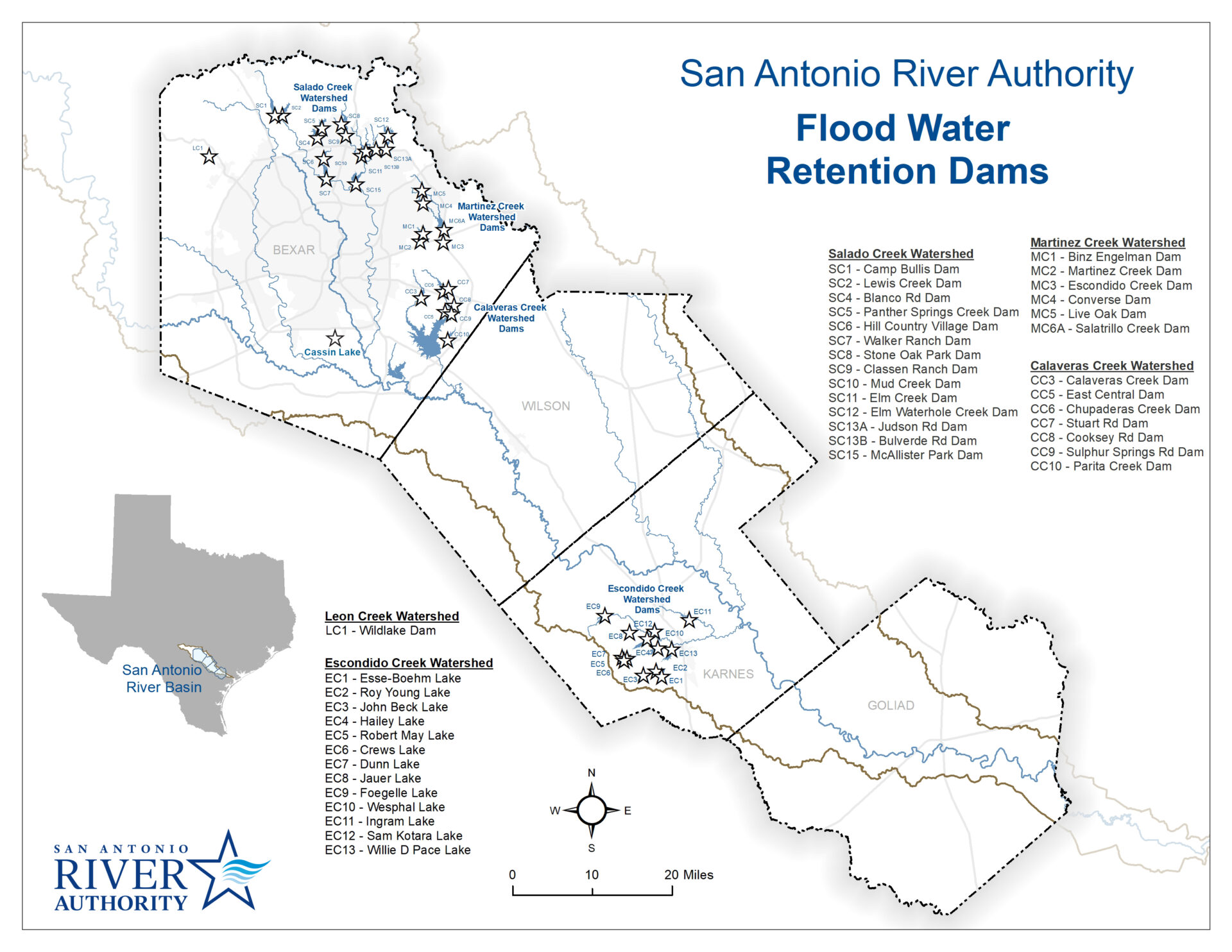
Dams throughout the San Antonio River Basin
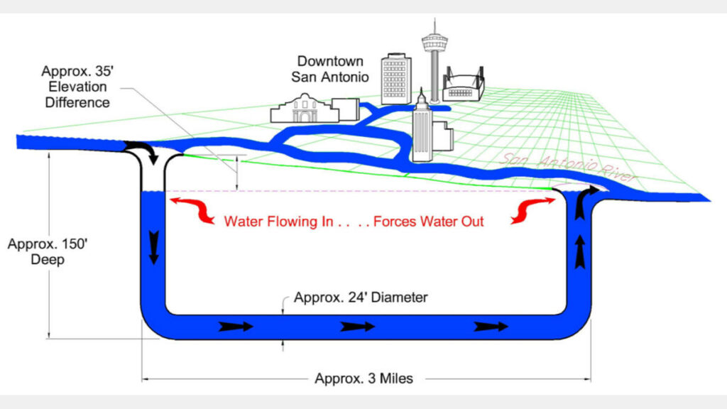
Tunnels Protecting Downtown San Antonio
Additional Methods and Strategies
In addition to constructing dams and tunnels, the River Authority uses other methods and strategies to provide an added layer of flood protection. These are typically lower cost and focus on pre-emptive actions including ordinances that help reduce flood threat, public awareness and flood resiliency. Some examples include flood warning systems, policy and regulations, awareness tools and campaigns, and community-wide participation in flood insurance programs.
The River Authority is a strong advocate of stream restoration and has developed a manual for creating natural channels for rivers, streams and creeks in the watershed.
Watch an earthen dam in action as it holds back flood waters, and gently releases the water on the other side.
Degraded or highly industrialized streams can negatively affect property and human health in the following ways:
- Excessive levels of erosion reduce water quality
- Areas of excessive sediment buildup may cause flooding
- Polluted runoff can render streams unsafe for contact and fishing
- Higher temperature runoff can rapidly change the condition of water, negatively affecting wildlife
- Increased water volume and velocity undercuts roads, sewer systems, and storm drains, increasing costs of public service.
Through stream restoration, many of these negative impacts can be addressed and reversed.
Preparedness
The River Authority works and coordinates with many other governmental entities to improve the watershed’s flood preparedness. The Bexar Regional Watershed Management partnership (BRWM) website shares preparedness information on the “what you can do” page. Another good source of information is the Texas Water Development Board’s TexasFlood.org website. The information contained at these websites describe how a resident can be informed and take proactive steps to improve their flood preparedness.
Mitigation
The River Authority also advocates for Low Impact Development (LID) techniques as a mitigation strategy. When paired with green strategies such as stormwater parks, floodplain preservation, shared parking and complete green streets, these practices help address water quantity and quality concerns associated with the region’s frequent, smaller rain events. A common threat from unmitigated impervious cover, such as streets and rooftops, and from removal of native soils and plants, is street flooding during storms. But the negative effects don’t end there. Rainwater runoff picks up bacteria, oils, hydrocarbons, sediment, fertilizers and other contaminants from yards, fields, sidewalks, parking lots and streets and deposits these contaminants into our creeks and rivers. Even small rain storms in urban areas cause problems. High concentration of “first flush” pollutants from runoff can reduce a creek’s dissolved oxygen, resulting in fish kills. LID techniques have been shown to improve water quality, reduce localized flooding and, when incorporated into a project’s design early in the process, offset and in some cases reduce the cost of traditional development.