MY River POV: Michelle Garza

Written by:

Posted on:

Categories:

Share:

Facebook
Twitter
LinkedIn
Email

Get The Latest:

Join our print or digital newsletter to be informed about the agency’s many projects and other news.

Decorative banner for blog titled: "My River Point of View"

Last Updated on January 30, 2024

The “My River POV” series provides readers the opportunity to learn about the unique insight and experiences of the San Antonio River Authority (River Authority) staff and their personal connection to the San Antonio River in hopes of inspiring stewardship of area creeks and rivers.


Michelle Garza, Environmental Data Specialist

Raised on the outskirts of San Antonio, I grew up in a small, modest, rural neighborhood off Highway 16 in Von Ormy. My love for the river came from trips to Concepcion Park, a city-owned park in San Antonio, and fishing trips on the Medina River. My parents were in a church softball league, and we were brought on many trips to the park. As my parents played softball, my five siblings and I would venture and explore the park and run through the trails among the trees and brush found along the backside of the park. Before long, we’d find ourselves down at the banks of the San Antonio River, staring into the water and looking for small fish or turtles. We’d even wade in the water, trying to cool off on those hot summer days.

Concepcion Park rendering

Concepcion Park near the San Antonio River

It wasn’t until I came to work at the San Antonio River Authority (River Authority) in 1991 that I questioned the safety of wading and swimming in the river and its tributaries as a child. Pollution comes from various sources. During rainfall events, nonpoint source pollution, such as runoff carrying pollutants from driveways, streets, and parking lots, is washed into our streams and rivers and negatively affects the river’s water quality. Learning about the harmful effects of this pollution grew my passion for protecting and preserving the river. I wanted to work for an agency whose mission included the protection of the constituents living along and within the boundaries of the San Antonio River Watershed and the preservation of its ecosystems for future generations to enjoy. I realized how my actions and those from the community contributed to the health of our waterways.

Trash covers the river bank after rain event

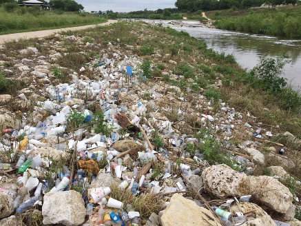
A typical sight: litter along the Mission Reach of the San Antonio River after a rain event. Nonpoint source pollution is a significant threat to the health of the San Antonio River Watershed.

Working as an Environmental Data Specialist, I’ve had the opportunity to analyze and visualize surface water quality data to improve water quality. I’ve participated in various monitoring projects and efforts, including the Clean Rivers Program. In this program, the Environmental Sciences Department staff and contracted partners routinely monitor and assess the San Antonio River and its tributaries. This information is used to help create the San Antonio River Watershed Water Quality Viewer. This viewer is an accessible online tool where you can 1) view monitoring stations, 2) explore water quality data and how it relates to your environment, 3) learn why your actions matter, and 4) view summarized assessments of the Texas Commission on Environmental Quality’s (TCEQ) Integrated Report.

San Antonio River Authority Water Quality Viewer

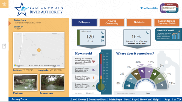
The River Authority’s San Antonio River Watershed Water Quality Viewer

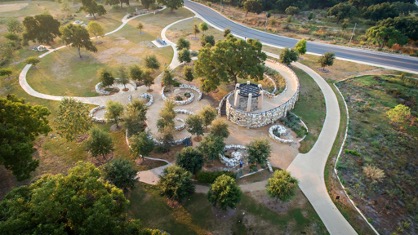
My love for the river and its tributaries has grown stronger as the years have passed. Concepcion Park isn’t the only space that has been transformed into a beautiful park with many natural amenities. Many River Authority parks, trails, and opportunities to access the San Antonio River and enjoy the environment, aquatic life, birds, and wildlife have come to fruition. I enjoy visiting the Museum Reach and Mission Reach of the San Antonio River walking paths, the John William Helton Nature Park in Floresville, and the Jackson Nature Park in Stockdale. The Jackson Nature Park is especially great for hiking, getting close to nature, and picnicking with friends and family. The best part of it all is that I’m one of many blessed with the opportunity to work for an agency that strives to make our rivers safe, clean, and enjoyable.

Jackson Nature Park

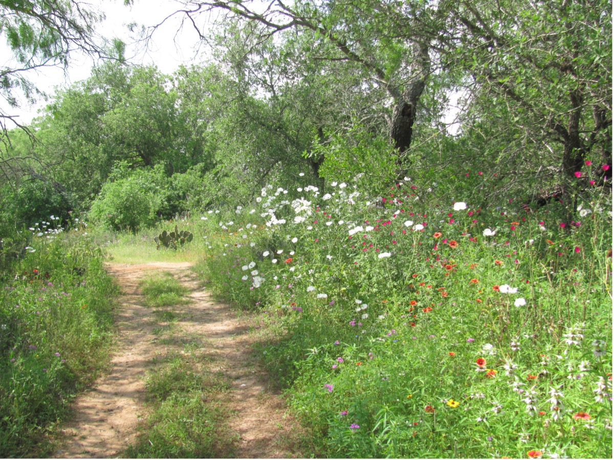
Jackson Nature Park in Stockdale, TX

Related Articles

Alerts

Stay Weather‑Aware This Weekend

Stay Weather‑Aware This Weekend

Rain is expected across the region this weekend, which may result in high water on roads and temporary closures at low water crossings.

Before heading out, residents are encouraged to check SARiverFlood.org or their local county flood website for real‑time roadway conditions:

These sites provide up‑to‑date information from flood‑monitoring sensors across the region. Real‑time updates are available 24/7 to help you stay informed as conditions change.

Please use caution when traveling and plan routes accordingly.

Restroom Closure Notice – Camino Coahuilteca (Acequia Park Trail)


Restroom Closure Notice – Camino Coahuilteca (Acequia Park Trail)

The restrooms at Camino Coahuilteca along the Acequia Park Trail will be temporarily closed on Thursday, April 16 due to parking lot improvements in the area.

We encourage visitors to plan accordingly and utilize nearby facilities during this time.

We appreciate your patience as we complete this work to enhance the park experience.


Museum Reach – Oxbow Trail Closure Notice

The Oxbow Trail along the Museum Reach will be temporarily closed beginning Monday, April 13 through May 1 to accommodate project-related work in the area.

For public safety, access to this section of the trail will be restricted during this time. Visitors are encouraged to plan accordingly and use alternate routes.

Wayfinding signage and trail closure notices will be posted at designated locations to help guide trail users around the closure.

We appreciate your patience and understanding as we complete this work to help maintain safe and enjoyable trail conditions.

San Pedro Creek Culture Park

The east bank trail along San Pedro Creek will be temporarily closed between the upper trail at Cameron St. and the lower trail at two access points.

Closure details:

  • The first closure will impact the connector from the upper trail near West Houston St. to the south lower San Pedro Creek trail.
  • Once work at this location is complete and the trail reopens, construction will shift to the second closure area between the upper and lower trails on the opposite side of the green space.

Please follow posted signage and plan alternate routes. We appreciate your patience as this work is completed.

Closed areas around San Pedro Creek Culture Park

The Brackenridge Trail

Trail Lighting Notice – Brackenridge Park Trail

Due to an electrical issue, lighting is currently out along the north portion of the trail, from the Josephine Street inlet to just past Highway 281 within the Brackenridge Park Trail. Our team is actively working to correct the issue and expects repairs to be completed by the end of business tomorrow.

We apologize for any inconvenience this may cause and appreciate your patience as we work to restore lighting. Please use caution when traveling through this area, especially during evening hours.

Trail Closure Alert – Calder Alley, San Pedro Creek

Maintenance work will be done in Calder Alley starting Wednesday, September 18, 2025.

  • Trails will remain open during this work.
  • One bench at a time will be temporarily barricaded while improvements are completed.
  • There may be occasional contractor pickups in the area.

We appreciate your patience as we continue to maintain and improve San Pedro Creek for all to enjoy!

SASPAMCO Paddling Trail

The SASPAMCO paddling trail is open from River Crossing Park to Helton Nature Park.
*Please Note: Paddling Trail from Helton Nature Park to HWY 97 is still closed due to blockages. 

SASPAMCO Paddling Trail Temporarily Closed

Staff have removed two large log jams just downstream of Helton Nature Park, keeping the southern portion of the SASPAMCO Paddling Trail temporarily closed. Staff are working to contact adjacent landowners to support a land-based removal solution.

Goliad Paddling Trail Alert

NOTICE: HWY 59 Landing Site Closed

Due to TxDOT construction on the HWY 59 Bridge, the HWY 59 landing site is closed until further notice. However, the Goliad Paddling Trail remains open, and paddlers can still access the river at the Riverdale, Ferry Street, and Goliad State Park landings.

Please plan accordingly and check back for updates.

River Reach Newsletter and Blog Signup

River Reach is offered as a printed, physical mailing to your residence or business. The Blog is a weekly electronic email with news and updates in order to be more environmentally conscious. Please fill out the form below and indicate your preferred method of delivery.

By submitting this form, you are consenting to receive marketing materials from: San Antonio River Authority, 100 East Guenther St., San Antonio, TX, 78204, US. You can revoke your consent to receive emails at any time by using the SafeUnsubscribe® link, found at the bottom of every email. Emails are serviced by Constant Contact. This site is protected by reCAPTCHA and the Google Privacy Policy and Terms of Service apply.