Are you and your home prepared for a flood?

Written by:

Posted on:

Categories:

Share:

Facebook
Twitter
LinkedIn
Email

Get The Latest:

Join our print or digital newsletter to be informed about the agency’s many projects and other news.

Loop 1604 flooded. Photo Credit: San Antonio Express-News

Last Updated on January 30, 2024

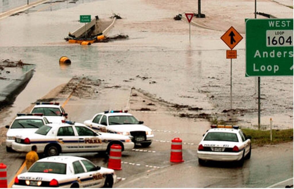
Within the San Antonio River Basin, the City of San Antonio and Bexar County have a long history of flooding, particularly flash flooding. As part of Flash Flood Alley, this large metropolitan area is one of the most flood-prone regions in North America. This is due to several factors, including geography, climate, and urbanization. The result is deep, fast, and erosive floodwaters that can potentially affect communities downstream, threatening lives and property throughout the basin, particularly in Bexar County, where urbanization can increase runoff up to 6 times over what would occur in natural areas. These flash flood events can occur within minutes to a few hours following a heavy rainfall event and, unfortunately, have included fatalities. In fact, floods and flash floods are some of the most fatal weather events in the U.S.

Flood management and risk reduction

Public safety through flood risk management is a top priority for the San Antonio River Authority. With documented increases in the intensity and destruction of major storms, such as Hurricanes Harvey and Ian, the most cost-effective way to prepare and respond to the impact of these storms is to ensure that hydraulic and hydrology information, rainfall data, land use changes, floodplain maps, watershed master plans, and capital improvement master plans stay current. The River Authority works with various local, county, and federal government collaborators to make the San Antonio River Basin safer from flooding. We do this by using scientific and engineering expertise to develop that data that supports other community funding decisions related to the development and implementation of flood mitigation projects. For 85 years, since the River Authority’s creation in 1937, cities and counties in our District and the Federal government, have relied on our engineering and technical expertise in flood management and risk reduction.


The River Authority manages and operates 41 floodwater retention dams throughout the San Antonio River Watershed, including this one in Eastern Bexar County. Dams are designed to re-direct and manage the flow of water, diverting it from inundating neighborhoods where people and property are dense.

Increase Your Flood Risk IQ with River Authority Resources

  • BexarFlood.org, a site funded by Bexar County and operated by the River Authority, shows the road conditions of monitored low water crossings across Bexar County. By subscribing to alerts through this website, you can receive text or email alerts when low water crossings you choose to monitor have water over the road.
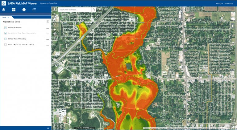
  • Check out the River Authority’s Floodplain Viewer and Risk MAP viewer, which allows a property owner to determine the level of flood risk across the life of the 30-year mortgage. The River Authority has invested considerable resources in developing updated floodplain maps throughout Bexar, Wilson, Karnes, and Goliad counties. This investment, combined with our expertise, has produced some of the highest quality floodplain maps in the United States.

Risk Map Viewer


Should I get flood insurance?

According to FEMA, there is some level of flood risk, no matter where you live or work. In fact, about 25% of all flood insurance claims come from areas with minimal flood risk. Therefore, the River Authority supports FEMA’s recommendation for homeowners to participate in the National Flood Insurance Program even if they are not required by their mortgage company to have flood insurance. The River Authority has included a grade for community flood insurance participation in the San Antonio River Basin Report Card, and unfortunately, the grade for this metric is an F, which indicates a significant amount of uninsured properties throughout the basin. Check out our website to learn more about obtaining flood insurance. Together, we can all do our part to make safety a priority.


The River Reach is back!

River Reach is a quarterly, 12-page newsletter that is designed to inform the San Antonio River Authority’s constituents about the agency’s many projects, serve as a communication vehicle for the board of directors and foster a sense of unity and identity among the residents of Bexar, Wilson, Karnes, and Goliad counties.

If you wish to be placed on the mailing list for River Reach, please contact us or complete the form.

Related Articles

Alerts

Stay Weather‑Aware This Weekend

Stay Weather‑Aware This Weekend

Rain is expected across the region this weekend, which may result in high water on roads and temporary closures at low water crossings.

Before heading out, residents are encouraged to check SARiverFlood.org or their local county flood website for real‑time roadway conditions:

These sites provide up‑to‑date information from flood‑monitoring sensors across the region. Real‑time updates are available 24/7 to help you stay informed as conditions change.

Please use caution when traveling and plan routes accordingly.

Restroom Closure Notice – Camino Coahuilteca (Acequia Park Trail)


Restroom Closure Notice – Camino Coahuilteca (Acequia Park Trail)

The restrooms at Camino Coahuilteca along the Acequia Park Trail will be temporarily closed on Thursday, April 16 due to parking lot improvements in the area.

We encourage visitors to plan accordingly and utilize nearby facilities during this time.

We appreciate your patience as we complete this work to enhance the park experience.


Museum Reach – Oxbow Trail Closure Notice

The Oxbow Trail along the Museum Reach will be temporarily closed beginning Monday, April 13 through May 1 to accommodate project-related work in the area.

For public safety, access to this section of the trail will be restricted during this time. Visitors are encouraged to plan accordingly and use alternate routes.

Wayfinding signage and trail closure notices will be posted at designated locations to help guide trail users around the closure.

We appreciate your patience and understanding as we complete this work to help maintain safe and enjoyable trail conditions.

San Pedro Creek Culture Park

The east bank trail along San Pedro Creek will be temporarily closed between the upper trail at Cameron St. and the lower trail at two access points.

Closure details:

  • The first closure will impact the connector from the upper trail near West Houston St. to the south lower San Pedro Creek trail.
  • Once work at this location is complete and the trail reopens, construction will shift to the second closure area between the upper and lower trails on the opposite side of the green space.

Please follow posted signage and plan alternate routes. We appreciate your patience as this work is completed.

Closed areas around San Pedro Creek Culture Park

The Brackenridge Trail

Trail Lighting Notice – Brackenridge Park Trail

Due to an electrical issue, lighting is currently out along the north portion of the trail, from the Josephine Street inlet to just past Highway 281 within the Brackenridge Park Trail. Our team is actively working to correct the issue and expects repairs to be completed by the end of business tomorrow.

We apologize for any inconvenience this may cause and appreciate your patience as we work to restore lighting. Please use caution when traveling through this area, especially during evening hours.

Trail Closure Alert – Calder Alley, San Pedro Creek

Maintenance work will be done in Calder Alley starting Wednesday, September 18, 2025.

  • Trails will remain open during this work.
  • One bench at a time will be temporarily barricaded while improvements are completed.
  • There may be occasional contractor pickups in the area.

We appreciate your patience as we continue to maintain and improve San Pedro Creek for all to enjoy!

SASPAMCO Paddling Trail

The SASPAMCO paddling trail is open from River Crossing Park to Helton Nature Park.
*Please Note: Paddling Trail from Helton Nature Park to HWY 97 is still closed due to blockages. 

SASPAMCO Paddling Trail Temporarily Closed

Staff have removed two large log jams just downstream of Helton Nature Park, keeping the southern portion of the SASPAMCO Paddling Trail temporarily closed. Staff are working to contact adjacent landowners to support a land-based removal solution.

Goliad Paddling Trail Alert

NOTICE: HWY 59 Landing Site Closed

Due to TxDOT construction on the HWY 59 Bridge, the HWY 59 landing site is closed until further notice. However, the Goliad Paddling Trail remains open, and paddlers can still access the river at the Riverdale, Ferry Street, and Goliad State Park landings.

Please plan accordingly and check back for updates.

River Reach Newsletter and Blog Signup

River Reach is offered as a printed, physical mailing to your residence or business. The Blog is a weekly electronic email with news and updates in order to be more environmentally conscious. Please fill out the form below and indicate your preferred method of delivery.

By submitting this form, you are consenting to receive marketing materials from: San Antonio River Authority, 100 East Guenther St., San Antonio, TX, 78204, US. You can revoke your consent to receive emails at any time by using the SafeUnsubscribe® link, found at the bottom of every email. Emails are serviced by Constant Contact. This site is protected by reCAPTCHA and the Google Privacy Policy and Terms of Service apply.