19th Street Labyrinth Weir Dam

19th Street Labyrinth Weir Dam

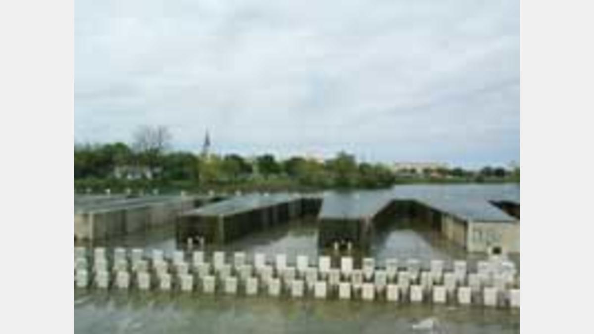
The labyrinth weir dam project was designed to replace an existing failing double gated structure built in 1973. The 2,000 foot-long labyrinth weir design was conceived in order to accommodate the floodwater in an area only 350 feet wide.

LABYRINTH WEIR DAM: Construction began in November 1993 after an extensive review process by the City of San Antonio Parks and Recreation Department, Planning Commission, Historic and Design Review Commission and Public Works Department, the Texas Natural Resource Conservation Commission, the U. S. Army Corps of Engineers and an adjacent neighbor, Our Lady of the Lake University. The Labyrinth Weir Dam was designed by Brown & Root, Inc. of Houston, Texas. Fernandez, Frazer, White and Associates of San Antonio, Texas did the landscape architectural design.

The $2.8 million construction contract was built by Shannon-Monk, Inc. of San Antonio, Texas. The costs were shared by the City of San Antonio (which contributed $1.2 million) and the San Antonio River Authority, through Bexar County Contract (which contributed $1.6 million). The above costs include design, right-of-way, construction, and administration for the project.

The project was completed in April 1995 and features a 2,000-foot fixed labyrinth weir flood control dam with a 10-foot depth at the dam, maintenance and siltation removal access ramps, improved security lighting around the perimeter of the dam and 19th Street bridge, sidewalks and improved landscape amenities to tie into the existing park space surrounding the project. The dam has a 100 year Q of 18,500 with a design depth of 1.9 feet over the spillway. Approximately 11,800 cubic yards of concrete were used to construct this dam.

past-projects-19thst-dam-1_sm

Project Details:

Share:

Facebook
Twitter
LinkedIn
Email

Related Projects

Sheridan Building Proposed Rendering

Facilities Design & Construction

This project involves the planning, design, and construction of a new facility at 201 W. Sheridan, aimed at supporting the River Authority's long-term operational and…

Parks Design and Construction

This project involves the design and construction of River Authority owned nature-based parks along the Medina River and San Antonio River. It aims to expand…

Edwards Aquifer Watershed Protection

This project is managed and administered by the River Authority for the City of San Antonio’s Proposition 1-funded Edwards Aquifer Protection Program. It supports water…

Alerts

Mission Reach Area Maintenance

When: Beginning October 20, 2025 through Spring 2026
What: Crews will be performing stem-density removal and related vegetation maintenance along sections of the Mission Reach to help manage flood risk and protect surrounding infrastructure. Some trails or segments may be closed temporarily while work is underway.
Why: Removing excess stems that naturally establish along the river helps maintain stormwater conveyance, reduces flood risk, and protects public infrastructure while allowing grassland and native vegetation to recover and thrive.
What to expect:

  • Limited trail closures and intermittent work zones.
  • Crews and equipment working near the riverbanks during daytime hours.
  • Parking areas remain open, but visitors may see signage and temporary barriers.

Questions? Call the San Antonio River Authority at (210) 227-1373 or visit https://www.sariverauthority.org/services/river-health/ecosystems/.

Thank you for your patience while we keep the Mission Reach safe, clean, and enjoyable.

Stem Density work 12.10.2025-12.19.2025

Trail Closure Alert – Calder Alley, San Pedro Creek

Maintenance work will be done in Calder Alley starting Wednesday, September 18, 2025.

  • Trails will remain open during this work.
  • One bench at a time will be temporarily barricaded while improvements are completed.
  • There may be occasional contractor pickups in the area.

We appreciate your patience as we continue to maintain and improve San Pedro Creek for all to enjoy!

SASPAMCO Paddling Trail

The SASPAMCO paddling trail is open from River Crossing Park to Helton Nature Park.
*Please Note: Paddling Trail from Helton Nature Park to HWY 97 is still closed due to blockages. 

SASPAMCO Paddling Trail Temporarily Closed

Staff have removed two large log jams just downstream of Helton Nature Park, keeping the southern portion of the SASPAMCO Paddling Trail temporarily closed. Staff are working to contact adjacent landowners to support a land-based removal solution.

Goliad Paddling Trail Alert

NOTICE: HWY 59 Landing Site Closed

Due to TxDOT construction on the HWY 59 Bridge, the HWY 59 landing site is closed until further notice. However, the Goliad Paddling Trail remains open, and paddlers can still access the river at the Riverdale, Ferry Street, and Goliad State Park landings.

Please plan accordingly and check back for updates.

River Reach Newsletter and Blog Signup

River Reach is offered as a printed, physical mailing to your residence or business. The Blog is a weekly electronic email with news and updates in order to be more environmentally conscious. Please fill out the form below and indicate your preferred method of delivery.

By submitting this form, you are consenting to receive marketing materials from: San Antonio River Authority, 100 East Guenther St., San Antonio, TX, 78204, US. You can revoke your consent to receive emails at any time by using the SafeUnsubscribe® link, found at the bottom of every email. Emails are serviced by Constant Contact. This site is protected by reCAPTCHA and the Google Privacy Policy and Terms of Service apply.