When Rivers Rise Fast – Your Flood Toolkit: Resources to Stay informed and Prepared

Written by:

Posted on:

Categories:

Share:

Facebook
Twitter
LinkedIn
Email

Get The Latest:

Join our print or digital newsletter to be informed about the agency’s many projects and other news.

A phone displaying the BexarFlood.org.

When Rivers Rise Fast - Your Flood Toolkit: Resources to stay informed and prepared

We’re introducing a new blog series called “When Rivers Rise Fast” to support our community in preparing for and responding to flash floods.

This series will provide valuable information, including a detailed look at the new flood warning system we’re implementing, and a clear explanation of what flash flooding is and why it’s so dangerous. We’ll also highlight essential tools and resources available to the public, empowering you to plan safer routes and avoid flood risks when you’re on the road. In this fourth post of the series, learn about the tools you can use to stay informed of severe weather, plan safer travel routes, and avoid flood risks.

What to Do During a Storm

A person holds a cellphone in one hand and an umbrella in another

  1. Watch the weather—look for flash flood watches or warnings and sign up for the following alerts to stay informed:
  1. Use org, TXDOT’s DriveTexas.org, and integrated map apps (ex. WAZE, Google Maps) to check crossings and road closures before driving.
  2. DO NOT DRIVE through floodwaters– even a small amount can cause a vehicle to lose control, and they can also contain harmful substances.
  3. Move to higher ground quickly when warned (see #1 to sign up for alerts)
  4. Teach your family about low‑water crossings and flood risks.

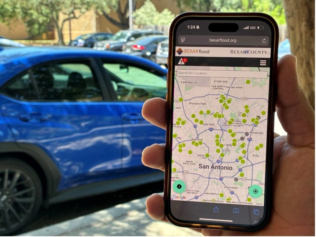
BexarFlood.org: A Lifesaving Alert System

A phone displaying the BexarFlood.org.

A low‑water crossing is a type of road that is built at a low elevation to pass over a body of water, like a creek or river. When water is low, it’s easy to drive—but in floods, water rapidly covers the road, making it dangerous to cross.

Bexar County, the City of San Antonio, and the River Authority utilize BexarFlood.org, a HALT (High‑Water Alert Lifesaving Technology) to help alert the public of the status of low water crossings.

BexarFlood.org can:

  • Measure rising water with sensors at over 190 crossings.
  • At certain locations, when water gets high, drivers can see flashing lights and/or gates telling them to stop.
  • Show real-time colorcoded maps of low-water crossings: green = safe, yellow = water rising, red = closed
  • Works with Waze and Google Maps so you see road hazards while driving. These map apps can be downloaded on mobile devices* from app stores.

*The San Antonio River Authority strongly recommends utilizing hands-free technology while driving to ensure the driver remains alert to the road conditions.

 Plan Your High Road Route

Mother explaining to her family the assembly point map while preparing emergency backpacks

In addition to checking BexarFlood.org and using map apps like Waze or Google Maps, identify a “high road” route between your most frequent destinations—such as home, work, and school. This route should avoid low-water crossings and flood-prone roads as much as possible. Practice it in clear weather so you know exactly where to go during heavy rain.

The Big Picture: Regional Collaboration, Real Impact

Floods aren’t going away, but with the launch of the NextGen Flood Warning System, we’re building a more resilient region and investing in systems that provide faster warnings, better data, and more protection for our residents.

Flooding doesn’t recognize city limits or county lines, so our response can’t either. Regional collaboration is essential because water flows across political boundaries, and protecting lives requires a united effort. It’s not just about infrastructure; it’s about people. Every sensor, every map, every alert helps turn uncertainty into action—and action into lives saved.

Related Articles

Alerts

The Brackenridge Trail

Trail Lighting Notice – Brackenridge Park Trail

Due to an electrical issue, lighting is currently out along the north portion of the trail, from the Josephine Street inlet to just past Highway 281 within the Brackenridge Park Trail. Our team is actively working to correct the issue and expects repairs to be completed by the end of business tomorrow.

We apologize for any inconvenience this may cause and appreciate your patience as we work to restore lighting. Please use caution when traveling through this area, especially during evening hours.

Mission Reach Area Maintenance

*FEBRUARY 2026 UPDATE*

Acequia Park Trailhead will be temporarily closed due to ongoing Stem Density work. The closure area includes the section south of Theo Avenue and Probandt Street, extending south to Mission Road. Currently, work is taking place only on the west bank. The east bank portion of the project has been completed. Trails will be reopened Thursday (02/05) through the weekend and will close again early Monday (02/09) morning. Ongoing work will take place from Monday mornings through late Thursday afternoons. We appreciate your patience as we complete this important work to maintain and improve the park area.

When: Beginning October 20, 2025 through Spring 2026
What: Crews will be performing stem-density removal and related vegetation maintenance along sections of the Mission Reach to help manage flood risk and protect surrounding infrastructure. Some trails or segments may be closed temporarily while work is underway.
Why: Removing excess stems that naturally establish along the river helps maintain stormwater conveyance, reduces flood risk, and protects public infrastructure while allowing grassland and native vegetation to recover and thrive.
What to expect:

  • Limited trail closures and intermittent work zones.
  • Crews and equipment working near the riverbanks during daytime hours.
  • Parking areas remain open, but visitors may see signage and temporary barriers.

Questions? Call the San Antonio River Authority at (210) 227-1373 or visit https://www.sariverauthority.org/services/river-health/ecosystems/.

Thank you for your patience while we keep the Mission Reach safe, clean, and enjoyable.

Mission Reach Trail Closure 2.3.2026


Trail Closure Alert – Calder Alley, San Pedro Creek

Maintenance work will be done in Calder Alley starting Wednesday, September 18, 2025.

  • Trails will remain open during this work.
  • One bench at a time will be temporarily barricaded while improvements are completed.
  • There may be occasional contractor pickups in the area.

We appreciate your patience as we continue to maintain and improve San Pedro Creek for all to enjoy!

SASPAMCO Paddling Trail

The SASPAMCO paddling trail is open from River Crossing Park to Helton Nature Park.
*Please Note: Paddling Trail from Helton Nature Park to HWY 97 is still closed due to blockages. 

SASPAMCO Paddling Trail Temporarily Closed

Staff have removed two large log jams just downstream of Helton Nature Park, keeping the southern portion of the SASPAMCO Paddling Trail temporarily closed. Staff are working to contact adjacent landowners to support a land-based removal solution.

Goliad Paddling Trail Alert

NOTICE: HWY 59 Landing Site Closed

Due to TxDOT construction on the HWY 59 Bridge, the HWY 59 landing site is closed until further notice. However, the Goliad Paddling Trail remains open, and paddlers can still access the river at the Riverdale, Ferry Street, and Goliad State Park landings.

Please plan accordingly and check back for updates.

River Reach Newsletter and Blog Signup

River Reach is offered as a printed, physical mailing to your residence or business. The Blog is a weekly electronic email with news and updates in order to be more environmentally conscious. Please fill out the form below and indicate your preferred method of delivery.

By submitting this form, you are consenting to receive marketing materials from: San Antonio River Authority, 100 East Guenther St., San Antonio, TX, 78204, US. You can revoke your consent to receive emails at any time by using the SafeUnsubscribe® link, found at the bottom of every email. Emails are serviced by Constant Contact. This site is protected by reCAPTCHA and the Google Privacy Policy and Terms of Service apply.