
Last Updated on January 30, 2024
Happy New Year to all our readers and supporters of the San Antonio River Authority (River Authority) blog,
I hope you were able to enjoy time with family and friends over the holidays, and most importantly, spend your time safely. Safety seems especially appropriate to focus on during times of travel and pandemics. It is also a crucial part of our mission – keeping the San Antonio River Basin safe, clean, and enjoyable.
The “safe” part of our mission is where I have the most experience. Prior to joining the River Authority, I oversaw the Hurricane and Riverine Flood Defense System protecting New Orleans. I managed a network of 192 miles of levees and floodwalls plus over 250 floodgates that help protect a major metropolitan area and close to a million people from storm surge and river flooding. While the risks in the San Antonio River Basin are different, the fundamentals are the same – using engineering and science to help leaders make informed decisions and keep people safe. As you will read below, the River Authority accomplishes this mission in several ways.
Floodplain Mapping/Flood Insurance Program
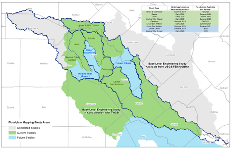
The River Authority has been a Cooperating Technical Partner (CTP) with the Federal Emergency Management Agency (FEMA) since 2003. Four years ago, the River Authority was voted best CTP in the nation, and we continue to work with local communities to implement FEMA programs and incorporate local knowledge and data into flood hazard mapping and mitigation planning. The River Authority is also one of only a handful of FEMA Letter of Map Revision (LOMR) delegates nationwide. As a delegate, we are responsible for performing the technical review function in our local community on behalf of FEMA. These designations exemplify the River Authority’s superior technical expertise in floodplain mapping and mitigation planning.
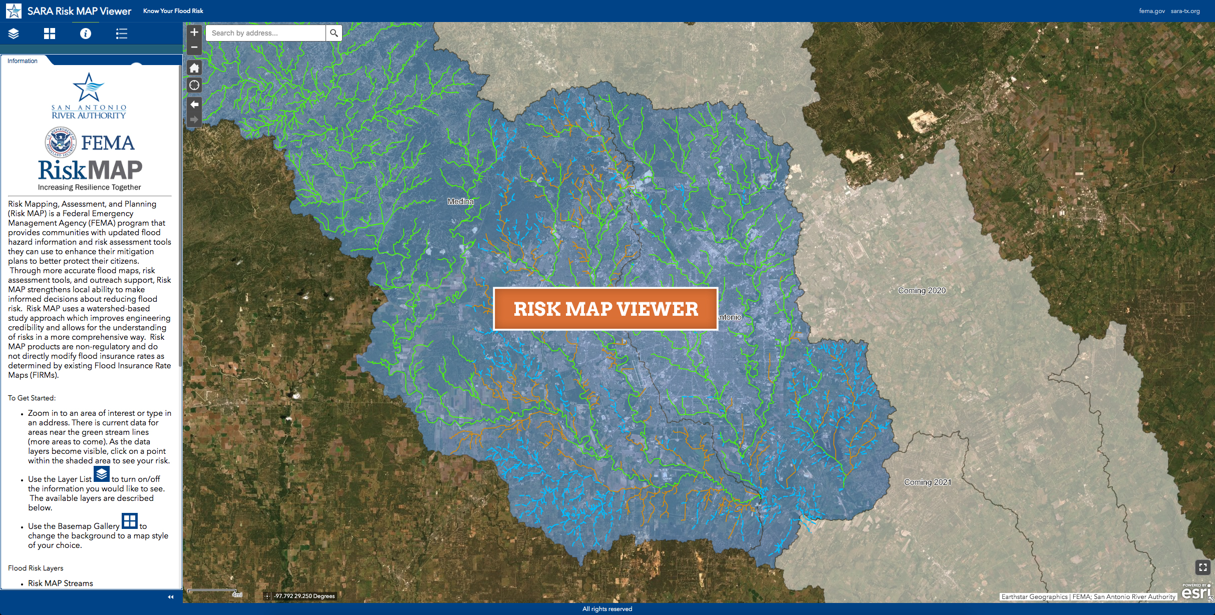
Since 2003, the River Authority has invested over $14 million to comprehensively map over 1,700 stream miles and digitally update old flood maps. Currently, the River Authority is updating floodplain maps to capture new development and incorporate updated rainfall data into the new Digital Flood Insurance Rate Maps (DFIRM); the most up-to-date data and floodplain maps are available for the public to view and utilize on our GIS-based Floodplain Web Viewer. In addition to creating the DFIRMs for the San Antonio River Basin, which are FEMA regulatory floodplain maps, we are also coordinating with FEMA to create a Risk MAP Viewer, which is a non-regulatory mapping tool that provides citizens and communities with updated flood hazard information and risk assessment tools they can use to enhance their mitigation plans.
The River Authority encourages homeowners to use these GIS mapping tools to assess their home’s flood risk and consider obtaining flood insurance to help protect their property from flood damage.
Predictive Flood Analysis
Being able to accurately predict rainfall and the associated impacts on river and stream flooding is critical to helping people stay out of harm’s way. The River Authority has a team of expert engineers who use special software, combined with forecasts from the National Weather Service and gauge data (for both rain and stream/river levels) to predict where it will rain in Bexar County and how that rainfall will cause streams and rivers to rise. The River Authority then feeds this data to the Bexar County and City of San Antonio Emergency Operations Centers (EOC) to assist emergency management leadership and first responders in determining road and low water crossing closures, routing emergency management services such as police, fire, and EMS, and sending out warnings to the public. The River Authority is exploring the development of the same predictive flood analysis for Wilson, Karnes, and Goliad counties.
The predictive flood modeling system designed for use by EOC emergency management leadership is not a public-facing system. However, in cooperation with Bexar County, a website was developed to provide Bexar County residents easy access to road closure information due to flooding; during rain events, citizens are encouraged to visit bexarflood.org to learn about road closures that may impact them.
Dam Safety
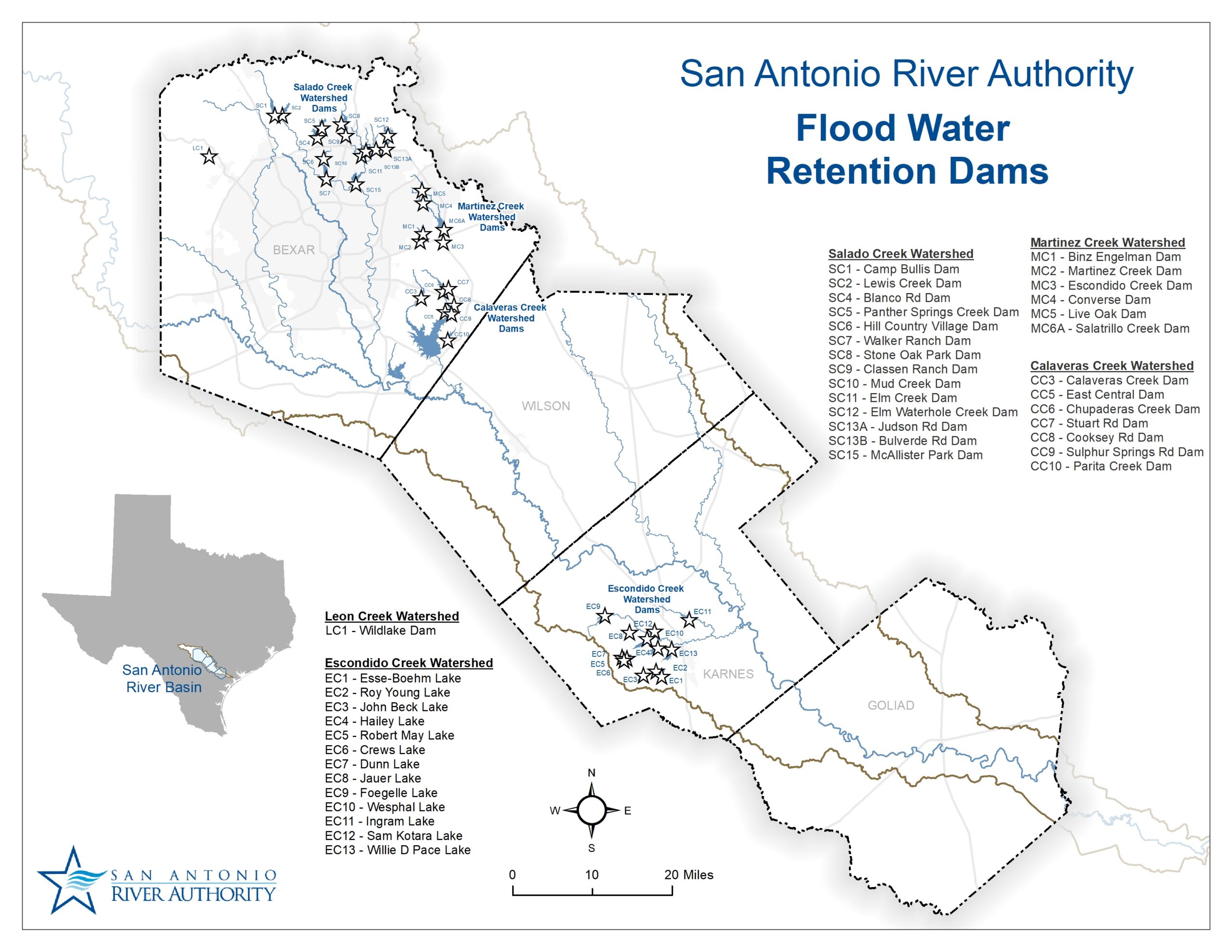
Many people are unaware that the River Authority operates 41 flood retention dams throughout the San Antonio River Basin: 28 in Bexar County on the Calaveras, Leon, Martinez, and Salado Creek Watersheds, and 13 dams in Karnes County on the Escondido Creek Watershed. Most of these dams were built in the 1960s and 1970s, with McAlister Park Dam being the most recently built in 2003. These dams mitigate flooding in populated areas and are designed to withstand up to 44 inches of rain over 24 hours. The River Authority works with many partners, including the City of San Antonio, Bexar County, Karnes County, Escondido Watershed District, Hondo Watershed District, the City of Kenedy, and the Karnes County Soil and Water Conservation District. Our dam safety professionals inspect, operate, and maintain these dams in accordance with Federal Natural Resources Conservation Service (NRCS) standards and remain on-call 24-7 during heavy rain events to ensure the dams are operating properly and people remain safe.
Finally, the River Authority’s flood mitigation expertise is also recognized by the Texas Water Development Board (TWDB). In April 2020, the TWDB appointed the River Authority as the administrative agency for the State of Texas-designated Region 12 San Antonio Regional Flood Planning Group (SARFPG), which is part of the state’s plans to provide comprehensive regional flood planning across the state.
For close to 85 years, cities and counties in the River Authority’s District, as well as the Federal government, and now, the State of Texas, have relied on our engineering and technical expertise in flood management and risk reduction. We will continue our commitment to safe, clean, and enjoyable creeks and rivers into the New Year and beyond. May your 2022 be safe, healthy, and happy.