Last Updated on January 30, 2024
June is National Rivers Month, a time to pay tribute to all the magnificent rivers across our country, including the San Antonio River! This year’s National Rivers Month is especially important as it occurs during the United Nation’s Water Action Decade. Safe, clean, and enjoyable rivers help preserve wildlife and promote healthier lifestyles for the community. The San Antonio River Authority (River Authority) was created in 1937 by the State of Texas to preserve, protect, and manage the resources and environment of the San Antonio River Watershed. River Authority staff are responsible for carrying out the vision of inspiring actions for healthy creeks and rivers by harmonizing the needs of people and nature through stewardship of rivers and land.
During this National Rivers Month, we invite you to celebrate our local, precious freshwater resources, including your San Antonio River! Do you know the basics of the San Antonio River? Read below for a River 101!
Where does it Start?
Natural mineral water flowing from the Edwards Aquifer in Bexar County forms the humble origin of the San Antonio River, which has been home to indigenous peoples for over 12,000 years. There are numerous springs in the headwaters area. The San Antonio Spring is the largest and most well-known. Also known as the Blue Hole, it is located adjacent to the University of the Incarnate Word campus north of downtown San Antonio. The Blue Hole is an artesian spring at approximately 670 feet above sea level fed by the Edwards Aquifer.
The Blue Hole was once a fountain spring, rising up to twenty feet into the air.
How Long is the San Antonio River?
The San Antonio River flows just over 240 miles through Bexar, Wilson, Karnes, Goliad, and Refugio counties, where it converges with the Guadalupe River before finally flowing into San Antonio Bay on the Gulf of Mexico. The entire San Antonio River Watershed, a dynamic ecosystem of creeks and rivers, drains a land area of 4,194 square miles extending from Kerr and Medina counties in the Texas Hill Country southeast toward the Gulf of Mexico.
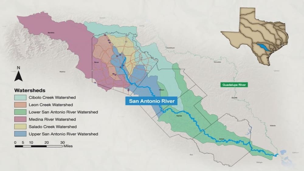
The San Antonio River Watershed is one of 23 major watersheds in Texas.
What is the largest threat to the health of the river?
Data from River Authority water quality monitoring indicates that the greatest threat to the San Antonio River’s health is various and all too common land pollutants from residential, school, and business properties. Pollutants such as litter, automotive fluids, lawn chemicals, bacteria from pet waste, and sediment are carried untreated by stormwater runoff across lawns, parking lots, streets, and into storm drains that direct the water into area creeks and rivers.
As more natural surfaces are paved and developed, less water percolates into the ground. Instead, more water goes over hard surfaces, picking up even more pollution en route to waterways. Using sustainable, green infrastructure practices, like residential rain gardens and permeable pavers, is one way you can prevent polluted stormwater runoff from entering our local creeks and river.
What activities can I enjoy along the river?
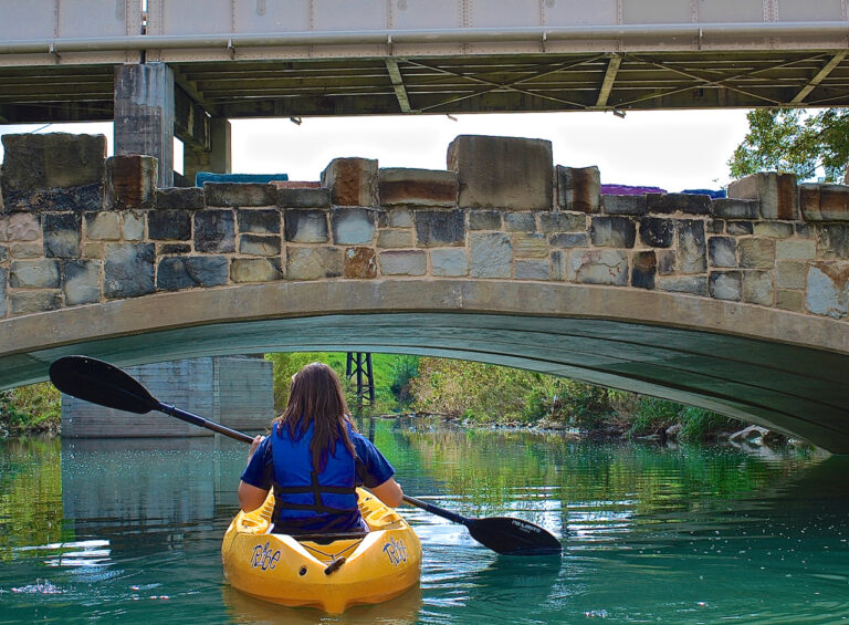
The River Authority operates and manages parks and trails throughout the San Antonio River Watershed, where the public can enjoy a variety of activities. In addition to exploring over 28 miles of hike and bike trails and more than 45 miles of paddling trails, we invite you to go camping, disc golfing, birdwatching, and more! As always, keep safety in mind as you explore the river.
What kinds of wildlife might I see along the river?
The San Antonio River Watershed ecosystem is home to a wide variety of plants and animals who rely on the health of area creeks and rivers as a vital feature of their habitat.
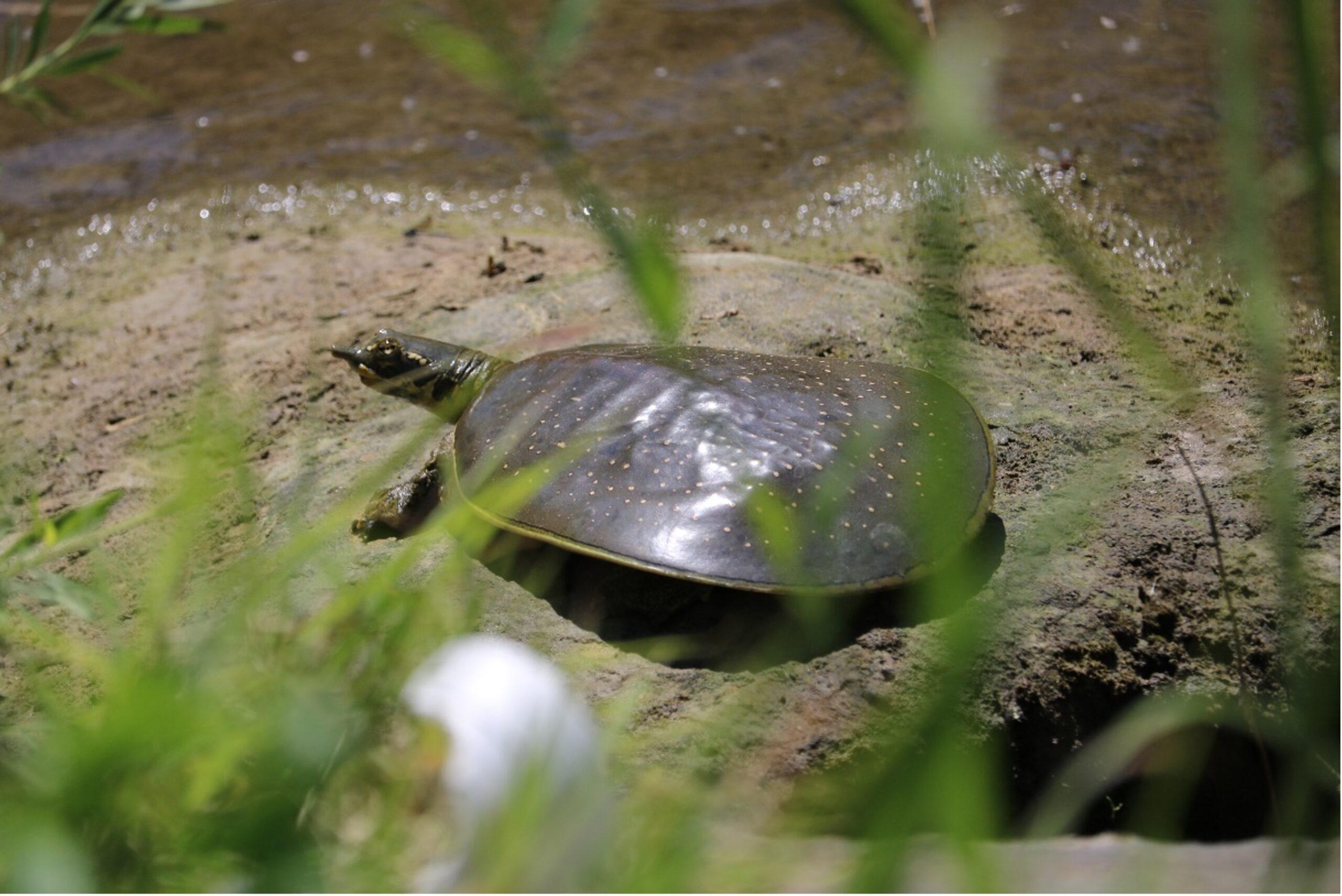
While walking along the river, you may notice a flat, circular object floating in the water. What first appears to be a pancake is actually a Guadalupe Spiny Softshell Turtle (Apalone spinifera guadalupensis)! This creature evades predators in two unique ways. Instead of a hard shell, they have a soft, flexible shell that allows for a swift escape from predators on the hunt. Their long snout enables their nostrils to stay above water while the rest of their body hides under the surface. Because their diet consists of aquatic insects and minnows, they rely on excellent water quality to support their food sources.
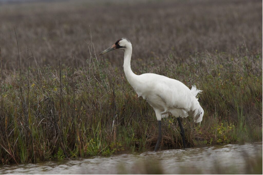
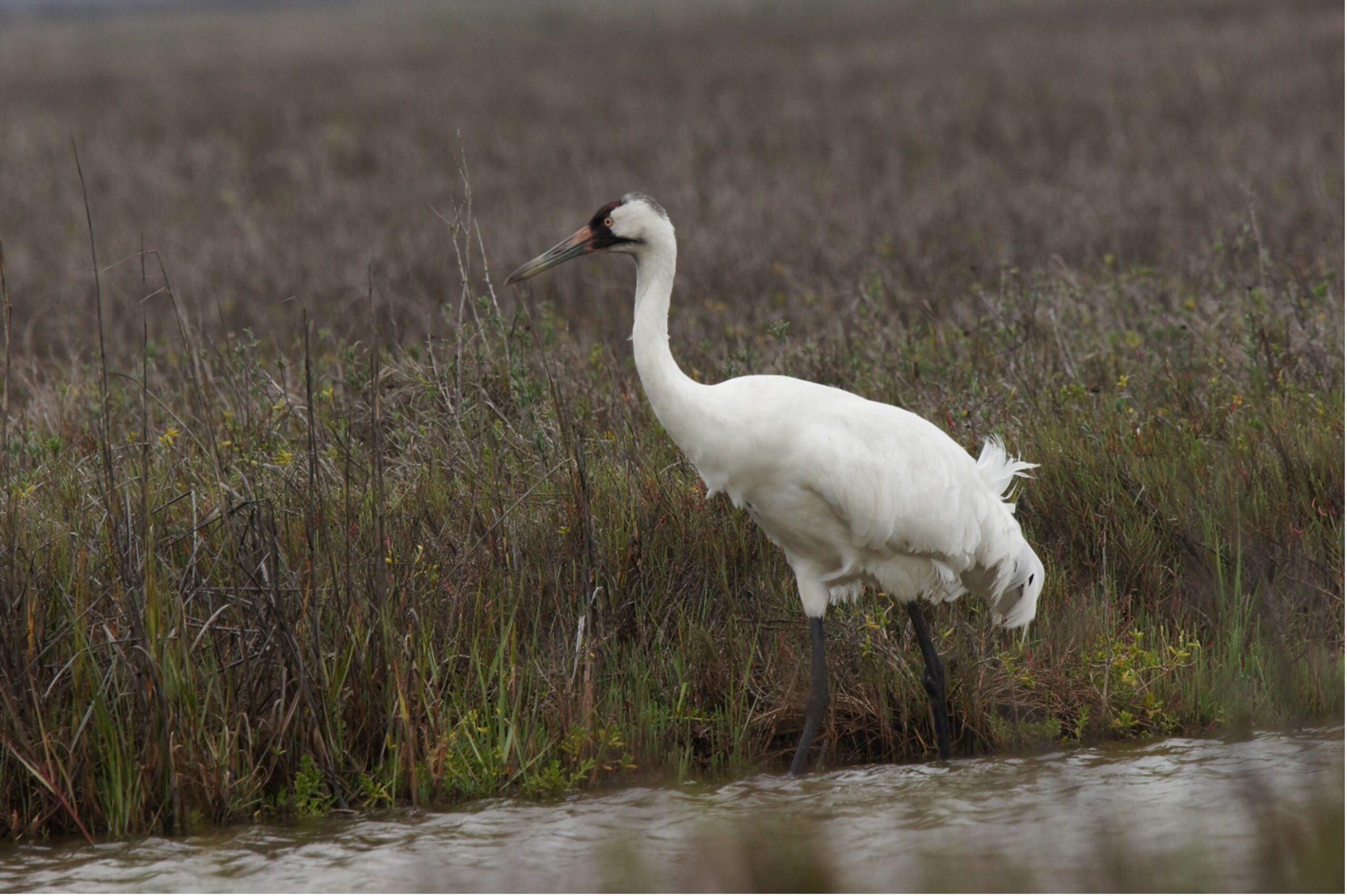
Visit the San Antonio Bay during the wintertime, and you may be lucky enough to come across the endangered Whooping Crane (Grus americana). Standing at a majestic 5 feet tall, Whooping Cranes are the tallest birds in North America. When their Canadian habitat becomes too frigid, these graceful birds will begin their long journey down to the bay, where they will find a perfectly balanced estuary that relies on freshwater from the Guadalupe and San Antonio Rivers and saltwater from the Gulf of Mexico. Water quality is of the utmost importance to conservation efforts that have increased the birds’ population from 16 in the 1940s to over 800 today.
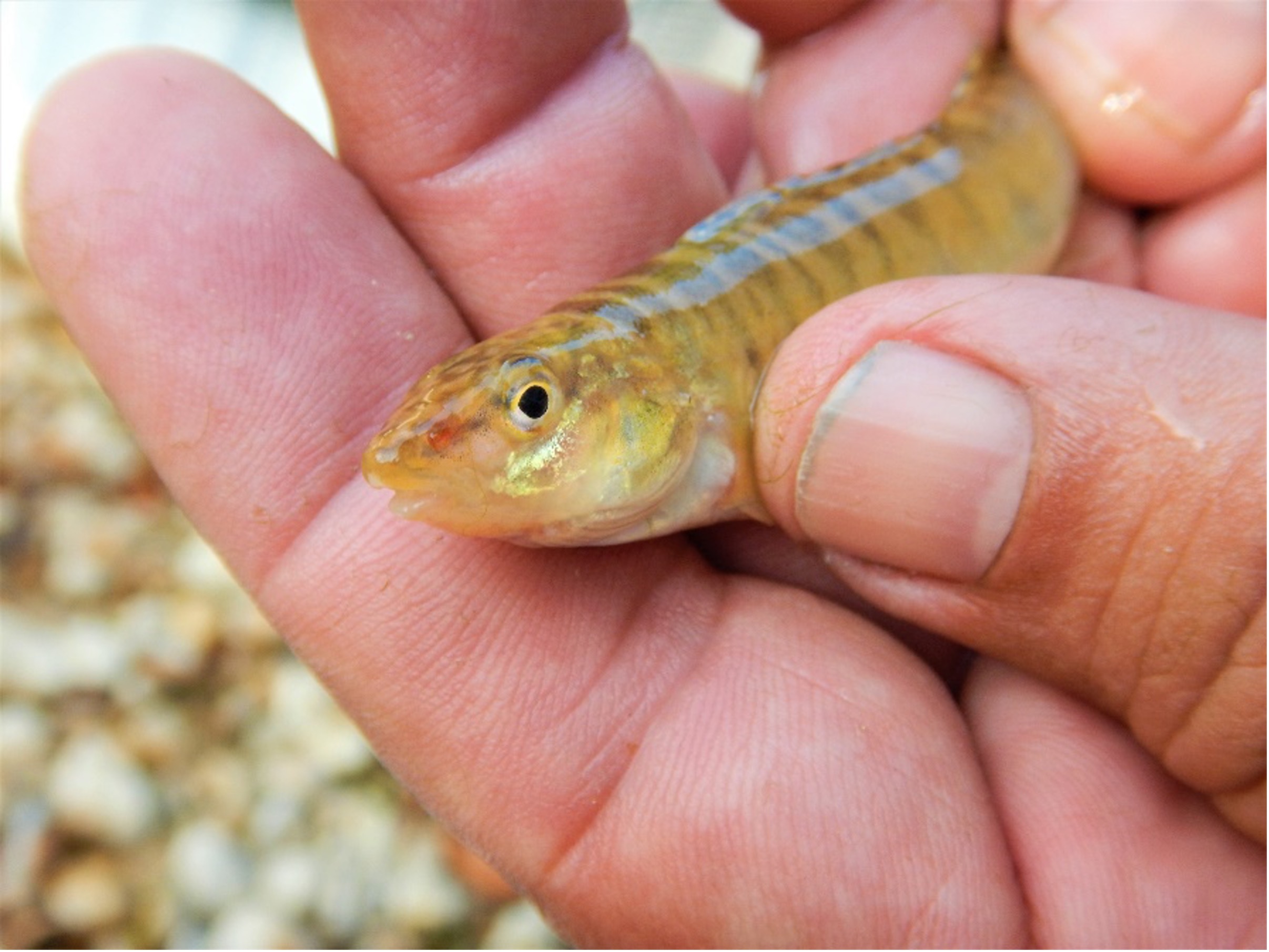
Have you noticed stretches of the river where the water is shallow and runs swiftly over rocky areas? This habitat feature is called a riffle, and it is home to the Texas Logperch (Percina carbonaria). These small fish use their lips to flip rocks over when searching for tasty insects living along the bottom of the river. Because the Texas Logperch is highly sensitive to pollution, finding one indicates excellent water quality.
How will I know of any closures along the river?
Information about the latest construction and maintenance activities can be found on our website.
I want to learn more about the san antonio River!
We invite you to visit the Education and History sections of our website to learn more and follow us on our social media channels @sanantonioriver. You can also follow along the San Antonio River’s journey from its underground origins to the Gulf of Mexico by watching the San Antonio to Seadrift documentary. This virtual tour will show off the river’s diverse wildlife and rich history as it passes by Spanish missions and winds through the ranches and coastal plains of South Texas.
The River Reach is back!
River Reach is a quarterly, 12-page newsletter that is designed to inform the San Antonio River Authority’s constituents about the agency’s many projects, serve as a communication vehicle for the board of directors and foster a sense of unity and identity among the residents of Bexar, Wilson, Karnes, and Goliad counties.
If you wish to be placed on the mailing list for River Reach, please contact us or complete the form here.