Confluence Park

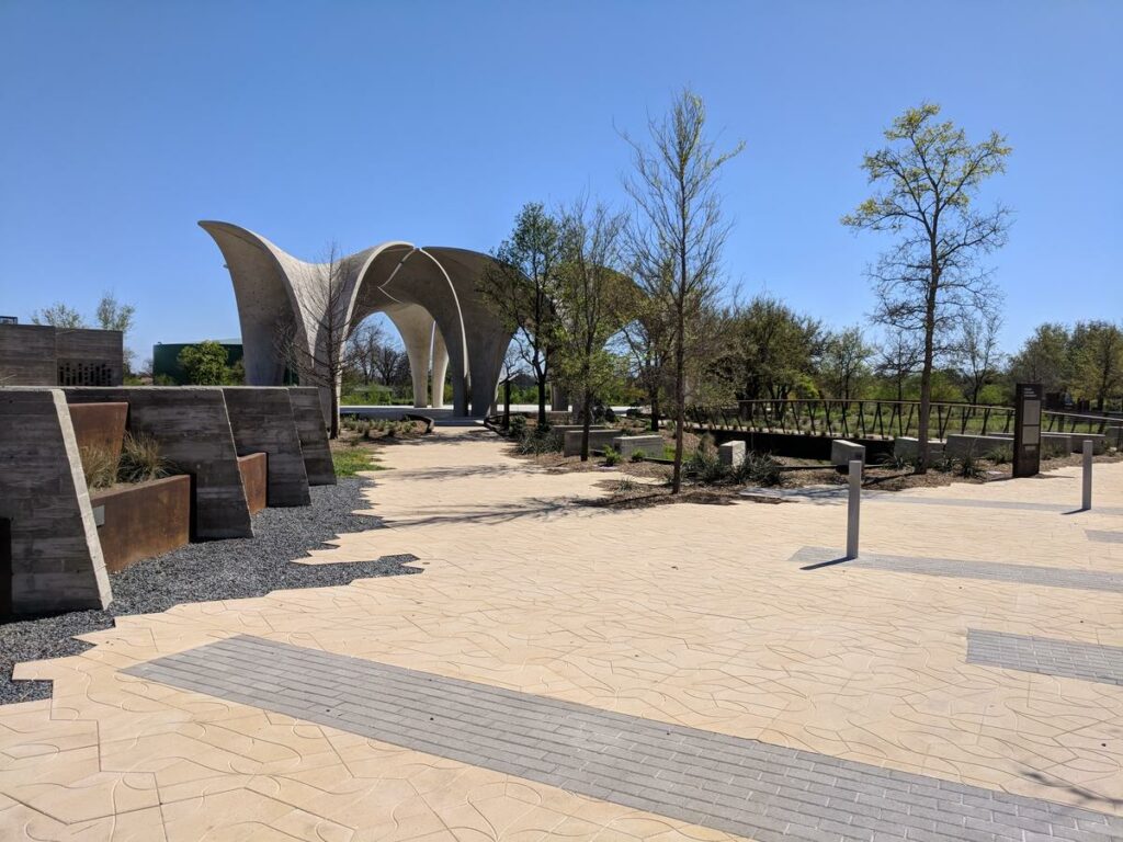
Confluence Park is the achievement that happens when organizations, the San Antonio River Authority and the San Antonio River Foundation (a non-profit organization) partner and use their strengths to create a unique space for place based learning. This park is as much of an architectural triumph as it is an environmental stewardship success. Visitors to this park learn how the park was built to work with the environment by utilizing unique design principals that catch, collect, and use the rain water that falls on the property. Confluence Park is also the place where San Antonio River Authority educators inspire actions for healthy creeks and rivers through the interpretation of the park’s dynamic features and nature based programming. The park is adjacent to the San Antonio River and close to the San Pedro Creek Trail and Mission Concepcion. You can walk along the banks of the San Antonio River, through part of a massive and scenic ecosystem restoration project, and connect to the San Antonio’s Missions in a new way.

Park Amenities:

Park Gallery:

Confluence Park

Park Map:

Park Details:

Downloadable Resources:

San Antonio River Walk Map

A full map of all River Walk Hike and Bike Trails, parks, points of interests, historic destinations collection of parks, trails, and historic destinations including San Pedro Creek Culture Park.

San Antonio River Basin Guide

A collection of parks, trails, and historic destinations throughout the San Antonio River Basin, including Bexar, Wilson, Karnes and Goliad Counties as well as the San Antonio River Walk (Downtown, Museum Reach and Mission Reach).

Share:

Facebook
Twitter
LinkedIn
Email

Alerts

Park Closure: Safety Notice

Safety Notice: The Lower River Access areas at Helton Nature Park and Graytown Park have been closed due to rising waters and potential flood risk.

Stay Weather‑Aware

Rain is in the forecast for our are starting Tuesday, June 2 until later this week. Heavy rains in short time spans may result in high water on roads and temporary closures at low water crossings. Before heading out, residents are encouraged to check SARiverFlood.org or their local county flood website for real‑time roadway conditions: These sites provide up‑to‑date information from flood‑monitoring sensors across the region. Real‑time updates are available 24/7 to help you stay informed as conditions change. Please use caution when traveling and plan routes accordingly.

San Pedro Creek Culture Park

The east bank trail along San Pedro Creek will be temporarily closed between the upper trail at Cameron St. and the lower trail at two access points. Closure details:
  • The first closure will impact the connector from the upper trail near West Houston St. to the south lower San Pedro Creek trail.
  • Once work at this location is complete and the trail reopens, construction will shift to the second closure area between the upper and lower trails on the opposite side of the green space.
Please follow posted signage and plan alternate routes. We appreciate your patience as this work is completed. Closed areas around San Pedro Creek Culture Park

Trail Closure Alert – Calder Alley, San Pedro Creek

Maintenance work will be done in Calder Alley starting Wednesday, September 18, 2025.
  • Trails will remain open during this work.
  • One bench at a time will be temporarily barricaded while improvements are completed.
  • There may be occasional contractor pickups in the area.
We appreciate your patience as we continue to maintain and improve San Pedro Creek for all to enjoy!

SASPAMCO Paddling Trail

The SASPAMCO paddling trail is open from River Crossing Park to Helton Nature Park. *Please Note: Paddling Trail from Helton Nature Park to HWY 97 is still closed due to blockages. 

SASPAMCO Paddling Trail Temporarily Closed

Staff have removed two large log jams just downstream of Helton Nature Park, keeping the southern portion of the SASPAMCO Paddling Trail temporarily closed. Staff are working to contact adjacent landowners to support a land-based removal solution.

Goliad Paddling Trail Alert

NOTICE: HWY 59 Landing Site Closed Due to TxDOT construction on the HWY 59 Bridge, the HWY 59 landing site is closed until further notice. However, the Goliad Paddling Trail remains open, and paddlers can still access the river at the Riverdale, Ferry Street, and Goliad State Park landings. Please plan accordingly and check back for updates.

River Reach Newsletter and Blog Signup

River Reach is offered as a printed, physical mailing to your residence or business. The Blog is a weekly electronic email with news and updates in order to be more environmentally conscious. Please fill out the form below and indicate your preferred method of delivery.

By submitting this form, you are consenting to receive marketing materials from: San Antonio River Authority, 100 East Guenther St., San Antonio, TX, 78204, US. You can revoke your consent to receive emails at any time by using the SafeUnsubscribe® link, found at the bottom of every email. Emails are serviced by Constant Contact. This site is protected by reCAPTCHA and the Google Privacy Policy and Terms of Service apply.