While all the metrics in the San Antonio River Basin Report Card have overlapping correlation to the safe, clean, enjoyable creeks and rivers aspects of the River Authority’s mission, the Community Flood Insurance Coverage grade is primarily related to the safe aspect.
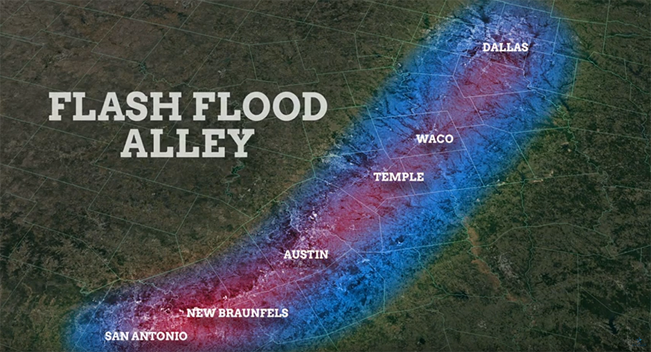
The River Authority focuses much of its technical expertise and resources to mitigating flooding because the San Antonio River Basin is part of a region known as Flash Flood Alley. The dangers and devastation of flooding are a very real risk for the communities we serve. Therefore, the River Authority, as a regional entity, works with the federal and state governments and leaders in Bexar, Wilson, Karnes, and Goliad counties to address flooding on a regional basis. Learn more about the River Authority’s leadership role in flood mitigation.
Floods are not only a high-risk natural disaster for the San Antonio River Basin, but according to the Federal Emergency Management Agency (FEMA), floods are the most common and costly natural disaster in the United States, affecting properties that have been identified in and out of high-risk flood areas. Historically, nearly 25% of all flood damage claims come from outside identified high-risk flood areas. FEMA also notes that, “people outside of high-risk flood areas filed 40% of all National Flood Insurance Program (NFIP) flood insurance claims between 2015 and 2019.” Everyone lives in a watershed, and no matter where your home is located within the San Antonio River Basin, there is a level of flood risk associated with your property.
Looking at Hurricane Harvey, which hit Texas in 2017, the flooding associated with it in Harris County supports the national outlook described above. According to the Texas Comptroller’s Hurricane Harvey report, A Storm to Remember, “FEMA estimated about 40% of all buildings flooded in Harris County were in areas considered to be ‘of minimal flood hazard.’” Further, the report cites that “researchers at the University of California at Davis determined half of the flooded land in Harris County was outside the boundaries of official flood maps.” Again, this demonstrates there is a level of flood risk associated with all properties throughout the San Antonio River Basin.
To show what may have happened if Hurricane Harvey hit downtown San Antonio, the River Authority created an animation that demonstrates the amount of river flooding alone that would have occurred. This conservative animated model does not show the additional street level urban flooding that would have happened if such a rainfall event hit the city, so an event of Harvey’s magnitude would likely be even worse than the model indicates.
With these statistics in mind, the River Authority thought it beneficial to “grade” the level of flood insurance coverage throughout our four-county jurisdiction of Bexar, Wilson, Karnes, and Goliad counties.
Grade for 2022:
F
How is this being measured?
A 2018 Insurance Information Institute Pulse survey found that 15 percent of American homeowners had a flood insurance policy, up from 12 percent who had the coverage in 2016. Using the percentage from the 2018 study as the national average for the purchase of flood insurance, we went to FEMA to find the number of flood insurance policies in force on an annual basis within communities, which FEMA produces. The River Authority, on an annual basis, receives single-family and multi-family residence statistics from the county appraisal districts. Using all this data from Fiscal Year 2021-22, this basin report card grade is determined by dividing the number of known flood insurance policies by the number of residences in each county of our jurisdiction. This percentage of flood insurance coverage by county within our district is then divided by the national average of 15% and finally multiplied by 100 to obtain the score by county. The four county scores are then averaged to identify the overall basin-wide grade for this report card.
Explanation of the Grade
Loading..........
The Data is Not Available
(7.6+7.8+5.4+20.3 = 41.1 / 4 = 10.3%)
Overall Grade for the San Antonio River Basin: F
Key Findings
This metric received a failing grade because homeowners within the San Antonio River Basin are well-below the national average for having flood insurance coverage. Given the tragic history of flooding in this region, particularly in Bexar County, a key finding is that this grade indicates an under-insured population, with regards to homeowner flood insurance. According to the Insurance Information Institute, the San Antonio River Watershed is not alone in being under-insured, “the number of policies in force has been declining from the high point of 5.7 million in 2009 to 4.95 million by August 2021.”
Recommended Actions
FEMA encourages all homeowners to get flood insurance, even if they don’t live in a high-risk flood zone. The River Authority supports FEMA’s recommendation because, while governments are doing all they can to alleviate the impact of flooding, everyone should play a role in protecting themselves.
The purchase of flood insurance is mandatory to qualify for Federal or federally backed financial assistance for the acquisition and/or construction of buildings in high-risk flood areas (Special Flood Hazard Areas). If the property is not in a high-risk area, but instead in a low- to moderate-risk area, the law does not require flood insurance; however, it is recommended since historically about one-in-four flood claims come from these low- to moderate-risk areas. Note that if during the life of the loan the maps are revised and the property is now in the high-risk area, your lender will notify you that you must purchase flood insurance. If you do not purchase flood insurance, the lender will purchase a policy on your behalf, which could be at a much higher rate. More information about Digital Flood Insurance Rate Maps, including FAQs about flood insurance can be found on the River Authority’s website. You can also learn more about flood insurance from a FEMA website.
It is also recommended that individuals learn more about flood risk in their area. The River Authority’s Floodplain Viewer engages users in an interactive floodplain map, displaying FEMA’s National Flood Hazard Layer (NFHL) data. The Risk MAP viewer created by the River Authority allows a property owner to determine the level of flood risk across the life of the 30-year mortgage. The River Authority encourages homeowners to assess their home’s flood risk, and for those interested in learning more, the River Authority has information available to the public about the science of flood management and our flood risk engineering studies.
Grade for 2021:
F
How is this being measured?
The 2018 Insurance Information Institute Pulse survey found that 15 percent of American homeowners had a flood insurance policy, up from 12 percent who had the coverage in 2016. Using the percent from the 2018 study as the national average for the purchase of flood insurance, we went to FEMA to find the number of flood insurance policies purchased on an annual basis within communities, which FEMA publishes. The River Authority, on an annual basis, receives single-family and multi-family homestead statistics from the county appraisal districts. Using all this data from Fiscal Year 2019-20, this basin report card grade is determined by dividing the number of known flood insurance policies by the number of homesteads in each county of our jurisdiction. This percentage of flood insurance coverage by county within our district is then divided by the national average of 15% and finally multiplied by 100 to obtain the score by county. The four county scores are then averaged to identify the overall basin-wide grade for this report card.
Explanation of the Grade
Loading..........
The Data is Not Available
Key Findings
This metric received a failing grade because homeowners within the San Antonio River Basin are well-below the national average for having flood insurance coverage. Given the tragic history of flooding in this region, particularly in Bexar County, a key finding is that this grade indicates an under-insured population, with regards to homeowner flood insurance.
Recommended Actions
FEMA encourages all homeowners to get flood insurance, even if they don’t live in a high-risk flood zone. The River Authority supports FEMA recommendation because, while governments are doing all they can to alleviate the impact of flooding, everyone should play a role in protecting themselves.
The purchase of flood insurance is mandatory to qualify for Federal or federally backed financial assistance for the acquisition and/or construction of buildings in high-risk flood areas (Special Flood Hazard Areas). If the property is not in a high-risk area, but instead in a low- to moderate-risk area, the law does not require flood insurance; however, it is recommended since historically about one-in-four flood claims come from these low- to moderate-risk areas. Note that if during the life of the loan the maps are revised and the property is now in the high-risk area, your lender will notify you that you must purchase flood insurance. If you do not purchase flood insurance, the lender will purchase a policy on your behalf, which could be at a much higher rate. More information about Digital Flood Insurance Rate Maps, including FAQs about flood insurance can be found on the River Authority’s website. You can also learn more about flood insurance from a FEMA website.
It is also recommended that individuals learn more about flood risk in their area. The River Authority’s Floodplain Viewer engages users in an interactive floodplain map, displaying FEMA’s National Flood Hazard Layer (NFHL) data. The Risk MAP viewer created by the River Authority allows a property owner to determine the level of flood risk across the life of the 30-year mortgage. The River Authority encourages homeowners to assess their home’s flood risk, and for those interested in learning more, the River Authority has information available to the public about the science of flood management and our flood risk engineering studies.
Grade for 2020:
F
How is this being measured?
The 2018 Insurance Information Institute Pulse survey found that 15 percent of American homeowners had a flood insurance policy, up from 12 percent who had the coverage in 2016. Using the percent from the 2018 study as the national average for the purchase of flood insurance, we went to FEMA to find the number of flood insurance policies purchased on an annual basis within communities, which FEMA publishes. The River Authority, on an annual basis, receives single-family and multi-family homestead statistics from the county appraisal districts. Using all this data from Fiscal Year 2019-20, this basin report card grade is determined by dividing the number of known flood insurance policies by the number of homesteads in each county of our jurisdiction. This percentage of flood insurance coverage by county within our district is then divided by the national average of 15% and finally multiplied by 100 to obtain the score by county. The four county scores are then averaged to identify the overall basin-wide grade for this report card.
Explanation of the Grade
Loading..........
The Data is Not Available
Overall grade for the San Antonio River Basin: F
(9.8 + 8.7 + 7.4 + 22.3 = 48.2 / 4 = 12.1%)
Key Findings
This metric received a failing grade because homeowners within the San Antonio River Basin are well-below the national average for having flood insurance coverage. Given the tragic history of flooding in this region, particularly in Bexar County, a key finding is that this grade indicates an under-insured population, with regards to homeowner flood insurance.
Recommended Actions
FEMA encourages all homeowners to get flood insurance, even if they don’t live in a high-risk flood zone. The River Authority supports FEMA recommendation because, while governments are doing all they can to alleviate the impact of flooding, everyone should play a role in protecting themselves.
The purchase of flood insurance is mandatory to qualify for Federal or federally backed financial assistance for the acquisition and/or construction of buildings in high-risk flood areas (Special Flood Hazard Areas). If the property is not in a high-risk area, but instead in a low- to moderate-risk area, the law does not require flood insurance; however, it is recommended since historically about one-in-four flood claims come from these low- to moderate-risk areas. Note that if during the life of the loan the maps are revised and the property is now in the high-risk area, your lender will notify you that you must purchase flood insurance. If you do not purchase flood insurance, the lender will purchase a policy on your behalf, which could be at a much higher rate. More information about Digital Flood Insurance Rate Maps, including FAQs about flood insurance can be found on the River Authority’s website. You can also learn more about flood insurance from a FEMA website.
It is also recommended that individuals learn more about flood risk in their area. The River Authority’s Floodplain Viewer engages users in an interactive floodplain map, displaying FEMA’s National Flood Hazard Layer (NFHL) data. The Risk MAP viewer created by the River Authority allows a property owner to determine the level of flood risk across the life of the 30-year mortgage. The River Authority encourages homeowners to assess their home’s flood risk, and for those interested in learning more, the River Authority has information available to the public about the science of flood management and our flood risk engineering studies.