When Rivers Rise Fast – Flash Floods Uncovered: How they happen and why they’re dangerous

Written by:

Posted on:

Categories:

Share:

Facebook
Twitter
LinkedIn
Email

Get The Latest:

Join our print or digital newsletter to be informed about the agency’s many projects and other news.

Flooding Car Submerged

When Rivers Rise Fast Uncovered: How they happen and why they're dangerous

We’re introducing a new blog series called “When Rivers Rise Fast” to support our community in preparing for and responding to flash floods.

This series will provide valuable information, including a detailed look at the new flood warning system we’re implementing, and a clear explanation of what flash flooding is and why it’s so dangerous. We’ll also highlight essential tools and resources available to the public, empowering you to plan safer routes and avoid flood risks when you’re on the road. In this second blog of the series, we’ll define flash flooding: what it is, how it happens, and why it’s so dangerous.

What is a Flash Flood?

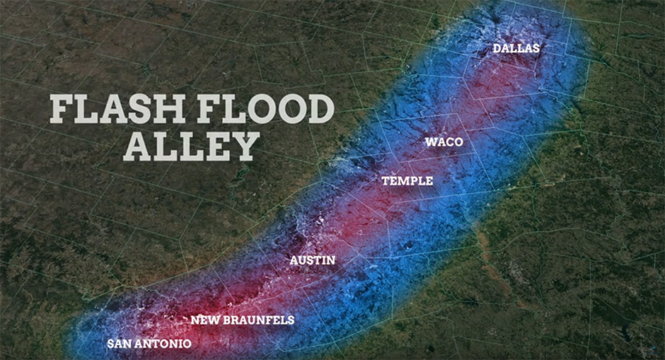
A flash flood is a fast, powerful flood caused by a large amount of rain falling over a short period of time, usually six hours. It can fill dry creeks and streets almost instantly. The Texas Hill Country—called “Flash Flood Alley”—is especially vulnerable because of steep rocky hills and soil that can’t soak up water well.

Number of Emergency Calls For Flooding

In urban areas, concrete and asphalt prevent water from soaking into the ground, so it quickly accumulates on streets and in low-lying areas. Because of these conditions, a thunderstorm doesn’t just bring rain—it can trigger flash floods that rise with alarming speed and turn dry creek beds into torrents of rushing water.


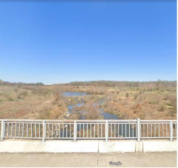
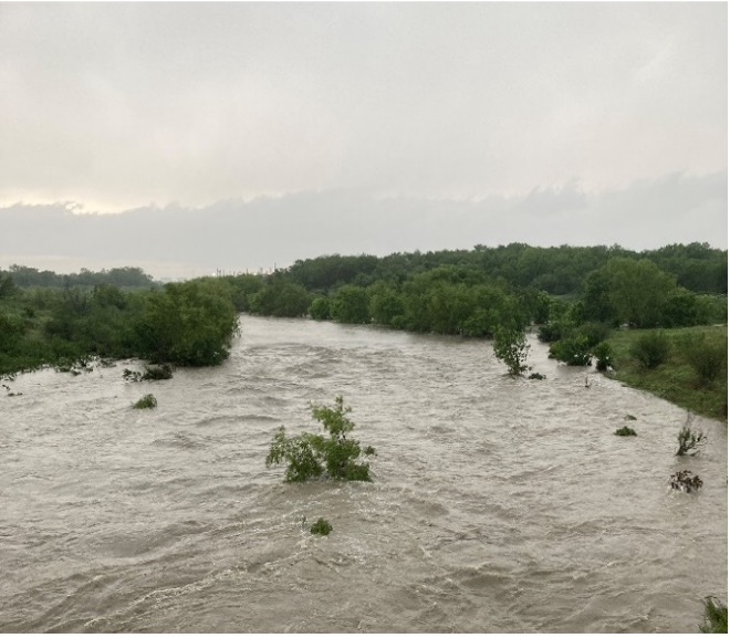
Flash flooding in action — the San Antonio River at Mission Road before (Left) and after (Right) a large rainstorm in April 2023.

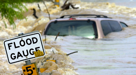
During a flash flood, a “wall of water” can form—a fast-moving surge filled with debris, mud, and tree limbs that can carry away cars, homes, and lives.

Flood Terms You Should Know

It is important for the public to know common terms and phrases used by the River Authority and the media when talking about flooding. These terms are:

  • A flood watch means heavy rain may happen soon, and flooding might occur, so be advised.
  • A flash flood warning means that dangerous flooding is happening right now—take action and move to high ground.
  • Flood stage: when a river reaches a danger level that may cause flooding in towns.
  • Gauge: a sensor that measures water in creeks or rivers.
  • Floodplain: land around a river that can Floodplains are mapped so that developers know where to build and people and homeowners can be made aware of their flood risk.
  • Turn Around, Don’t Drown: A safety slogan—don’t drive into flood waters, even if they seem shallow. Just a foot of moving water can carry your car away.

Car submerged in floodwaters

Flash floods are a serious and fast-moving threat. They can turn a peaceful day into a life-or-death situation in minutes. By understanding what they are and respecting the power of water, you can make informed decisions that will keep you and your loved ones safe.

Stay tuned for part three of our “When Rivers Rise Fast” series, where we’ll look at the River Authority’s role in protecting our watershed from flooding, publishing on September 19, 2025.

Related Articles

Alerts

Mission Reach Area Maintenance

When: Beginning October 20, 2025 through Spring 2026
What: Crews will be performing stem-density removal and related vegetation maintenance along sections of the Mission Reach to help manage flood risk and protect surrounding infrastructure. Some trails or segments may be closed temporarily while work is underway.
Why: Removing excess stems that naturally establish along the river helps maintain stormwater conveyance, reduces flood risk, and protects public infrastructure while allowing grassland and native vegetation to recover and thrive.
What to expect:

  • Limited trail closures and intermittent work zones.
  • Crews and equipment working near the riverbanks during daytime hours.
  • Parking areas remain open, but visitors may see signage and temporary barriers.

Questions? Call the San Antonio River Authority at (210) 227-1373 or visit https://www.sariverauthority.org/services/river-health/ecosystems/.

Thank you for your patience while we keep the Mission Reach safe, clean, and enjoyable.

Stem Density work 12.10.2025-12.19.2025

Trail Closure Alert – Calder Alley, San Pedro Creek

Maintenance work will be done in Calder Alley starting Wednesday, September 18, 2025.

  • Trails will remain open during this work.
  • One bench at a time will be temporarily barricaded while improvements are completed.
  • There may be occasional contractor pickups in the area.

We appreciate your patience as we continue to maintain and improve San Pedro Creek for all to enjoy!

SASPAMCO Paddling Trail

The SASPAMCO paddling trail is open from River Crossing Park to Helton Nature Park.
*Please Note: Paddling Trail from Helton Nature Park to HWY 97 is still closed due to blockages. 

SASPAMCO Paddling Trail Temporarily Closed

Staff have removed two large log jams just downstream of Helton Nature Park, keeping the southern portion of the SASPAMCO Paddling Trail temporarily closed. Staff are working to contact adjacent landowners to support a land-based removal solution.

Goliad Paddling Trail Alert

NOTICE: HWY 59 Landing Site Closed

Due to TxDOT construction on the HWY 59 Bridge, the HWY 59 landing site is closed until further notice. However, the Goliad Paddling Trail remains open, and paddlers can still access the river at the Riverdale, Ferry Street, and Goliad State Park landings.

Please plan accordingly and check back for updates.

River Reach Newsletter and Blog Signup

River Reach is offered as a printed, physical mailing to your residence or business. The Blog is a weekly electronic email with news and updates in order to be more environmentally conscious. Please fill out the form below and indicate your preferred method of delivery.

By submitting this form, you are consenting to receive marketing materials from: San Antonio River Authority, 100 East Guenther St., San Antonio, TX, 78204, US. You can revoke your consent to receive emails at any time by using the SafeUnsubscribe® link, found at the bottom of every email. Emails are serviced by Constant Contact. This site is protected by reCAPTCHA and the Google Privacy Policy and Terms of Service apply.