What is Stream Restoration?
When left in a natural state, streams are capable of performing myriad functions that are of value to humans, and the importance of these functions are the reason that humans have historically been drawn to live near streams and rivers.
However, many human activities can intentionally or unintentionally alter the basic physical and ecological structure of a stream, which can ultimately lead to a loss of these functions. When a stream’s functions have been compromised relative to its natural potential or historic functions, the stream is considered to be degraded or disturbed.
In its strictest form, stream restoration is defined as the transformation of a degraded stream corridor to its condition prior to human disturbance. But given the large scale degradation of landscape as a result of human activities, permanent return of the landscape to a pre-disturbed level is rarely achieved.
Therefore, a more common definition of stream restoration is to improve physical, chemical and biological functions of a stream system. Physical functions that might be improved are reduction in bank erosion and a self-sustaining water and sediment movement that does not require human intervention (such as dredging). Chemical function improvements might include higher water quality and greater removal of impurities as the water flows through the channel. Augmentations to biological function might be an expansion of habitat for diverse species, such as fish, aquatic insects and other wildlife.
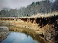
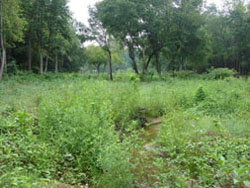
Highly degraded stream with severe bank erosion
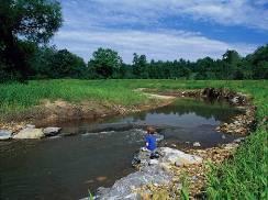
The same stream segment after restoration
Natural Channel Design (NCD)
Stream restoration is an interdisciplinary science that requires input from natural science, social science and engineering experts. Our team approach is to cross departmental lines to represent viewpoints of fluvial geomorphologists, engineers, hydrologists, aquatic biologists, natural resource specialists, operators, planners, educators and community relations experts. We believe the sum of the team is greater than the individual disciplines by themselves. Our approach is to develop in-house staff expertise in all phases of the work, including assessment, design, permitting, construction and monitoring. We believe our multi-discipline, diversified team approach will result in selecting appropriate project sites, providing efficient designs and implementing self-sustaining projects.
While many methods of stream restoration exist, the San Antonio River Authority’s (River Authority) stream restoration projects will focus on a particular restoration technique known as Natural Channel Design (NCD). The NCD approach relies on the principles of fluvial geomorphology to evaluate the current state of the degraded stream and that stream’s potential for restoring its historic functions. The fluvial geomorphology of a particular stream can include the interactions of climate, geology, topography, vegetation and land use in its watershed.
The end result of the NCD method develops a functional, self-sustaining stream system that provides valuable hydraulic (water transport), geomorphic (sediment erosion and transport) and ecological functions. By improving hydraulic and geomorphic functions, NCD creates a stable stream channel that can move water and sediment generated by its watershed while maintaining channel structural characteristics (such as dimension, pattern and profile) so that over time, the channel does not fill with sediment or erode continually downward.
The NCD approach uses more natural reference streams to compare the degraded stream functions with a functioning stream, provide a “blue print” for the stream restoration design and establish performance standards during post construction monitoring. In addition, establishing and maintaining good communication with the project stakeholders and using technical judgment on what is practical for each project site is a critical element to a technically successful and cost effective project. Further detail can be found in the Rosgen Stream Classification Technique section of the Natural Resource Conservation Service (NRCS) Engineering Manual.
As a part of NCD stream restoration projects, the relationship between the stream and its floodplain is returned to a condition that maximizes stream function. In a natural stream system, a stream will overflow its channel on average every 1.5 years, which allows pollutants to be processed on the floodplain, wetland-adapted plants to flourish in these areas and most stream functions of value to humans to be performed. However, the relationship between the stream channel and its floodplain can change under two main scenarios: stream degradation and intentional human alteration.
In a degraded stream system, channels can erode downward so deeply that it is no longer possible for water to come out of the channel during anything but an extremely large flood event, and few stream functions can occur. There are many methods of stream restoration available using NCD techniques to correct this problem, depending on the availability of space adjacent to the channel for increased water on the floodplain without damaging nearby infrastructure.
Bigger Challenges
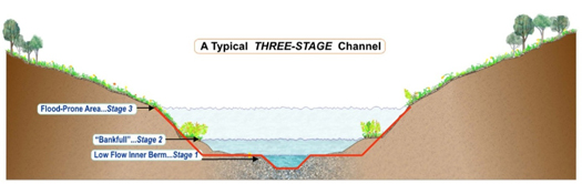
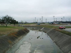
A more challenging situation is when streams are separated from their floodplains as a result of channelization projects that are used to protect infrastructure next to the stream. During channelization, the stream channel and its associated flood control channel (shown in red) is lowered below the original floodplain so much that only an extremely large flood event will bring waters in contact with its original floodplain. Channelization is an effective flood control method, but does little to allow the stream to function in a natural way and provide other benefits. To address this loss of function, an NCD Three-Stage Channel can be constructed within the flood control channel. This essentially allows a floodplain to be constructed within the flood control channel that is lower than the original floodplain. This allows for a more stable stream that performs more of the functions of a natural stream, without endangering the nearby infrastructure.
East Salitrillo Creek Pilot Project
On January 10, 2011, River Authority staff began construction on a stream restoration pilot project on East Salitrillo Creek in the City of Converse. The segment of the stream to be restored is a quarter-mile long and flows through Judson’s High School campus near Schaeffer Road. Prior to restoration, this segment of the stream was very unstable due to increased stormwater runoff from upstream development and the removal of deep rooted native grasses. The large amounts of stream erosion and lateral movement of the channel was endangering nearby infrastructure of utilities, roads and athletic fields and created sediment maintenance issues downstream.
Using natural channel design (NCD) principals, River Authority intends to restore the stream channel and riparian areas to a more natural condition using native materials and minimal structures to reduce existing maintenance costs for removing downstream sediment and repairing infrastructure. The ability of streams to transport sediment creates the stream form. The key to this design method is to balance sediment transport while enhancing natural stream functions. Some of the project design features include:
Stabilization
By partially realigning the stream and incorporating natural hardened structures into the stream at key locations, erosion of the channel can reduced significantly. Root wads (tree stumps with root mass attached) and vanes made of logs or boulders are placed on the outside bends to protect the bank soil. Structures made from boulders and logs are periodically being placed in the stream to dissipate energy and prevent erosion downward. Plunge pools lined with rock will dissipate the energy of stormwater as it enters the stream at two major tributaries.
Water Quality Treatment
Two bioswales will be constructed on the west side of the creek to treat stormwater inputs from Judson High School before it enters the stream. The bioswales will consist of littoral shelves (flat pools for water storage) separated by a boulder cascade. By storing water longer, plants and the bacteria that live in soil have more time to process pollutants that might otherwise go directly into the stream.
Degraded Streams Negatively Impact Individuals
Degraded streams can negatively affect human health and property in the following ways:
- Stream bank erosion can cause damage to yards and structures built too close to a stream. Erosion can undermine trees, causing them to fall and potentially damage property.
- Excessive levels of erosion reduce water quality while areas of excessive sediment buildup may cause flooding if not routinely maintained.
- Warmed and polluted runoff can render streams unsafe for contact and fishing.
- Decreased ground water recharge can lower well water levels and produce higher concentrations of pollutants.
- Increased water volume and velocity undercuts roads, sewer systems, and storm drains, increasing costs of public services.
- Poor aesthetics of nearby waterways can decrease property values.
Through stream restoration, many of these negative impacts can be addressed and reversed.
Capital and Maintenance Benefits
Traditional Methods
- Lack of attention to geomorphology results in periodic maintenance to replace eroded materials or remove sediment, such as dredging
- Channelizing the stream decreases channel stability and riparian habitat, impairs water quality and increases peak flows downstream
- By including hard armoring to stabilize the channel, infrastructure weakens over time and needs to be replaced
- Construction of armored structures in-stream means higher costs and erosion at transition structures
NCD Methods
- Takes into consideration sediment transport and tries to balance erosion and depositional forces so that the stream is stable over time
- Provides stability and valuable riparian habitat and improves water quality
- Uses natural stabilization methods such as large boulders and woody structures that support vegetation and do not need to be replaced
- Lower initial cost and lower maintenance cost if specific criteria are met
Functional Lift
The term “functional lift” describes the process by which a stream is elevated from a degraded state to a more naturally functioning ecosystem. By restoring the natural structure of a stream, through the construction of stream features such as pools, runs, riffles and floodplains, the NCD approach enables the stream to perform additional functions.
There are five different categories of stream function that can be considered in designing a NCD restoration project: hydrology, hydraulics, geomorphology, ecology and water quality. These categories can be represented in the form of a pyramid, because the establishment of some higher stream functions requires that the foundation of lower functions be in place first. Therefore, water quality improvements to the stream are the most dependent on the establishment of lower layers in the pyramid, where hydrology is the most independent of the stream characteristics.
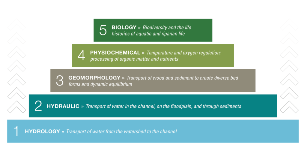
The NCD program design and maintenance parameters are adjustable to meet a wide range of project requirements. The level of functional lift achieved will be determined by the specific goals of each project and the project constraints. For instance, an urban flow conveyance project may be an ephemeral channel with a highly constricted right-of-way and floodplain issues. Site assessments for this project may indicate erosional issues that endanger infrastucture or sedimentation issues that impact conveyance. The NCD project goals at this site should focus on stream morphology that will stabilize the banks and balance sediment transport while maintaining or improving stormwater conveyance capacity. Please download the Pyramid diagram by Will Harmon, Stream Mechanics.
When significant numbers of NCD projects are effectively applied in a watershed, restoration can result in cumulative ecosystem benefits, including additional storage of flood waters, removal of pollutants by plant uptake and cohesion to the soil, additional recharge of groundwater and regulation of water temperature by shading the streams from direct sun. NCD projects also provide recreational and educational opportunities, and they improve aesthetics. These values are very important to a large majority of the public but are difficult to quantify in monetary terms.