What is Low Impact Development?
Low Impact Development (LID) is a sustainable land planning and design approach that manages stormwater on site. It is a set of tools specifically created to mitigate the pollutants and other unhealthy components of stormwater runoff. Examples are rain gardens, stormwater harvesting cisterns, and permeable pavement.
LID design
Maintains or enhances on-site natural features to drain the site and manage pollutants after development
- Reduces impervious cover and/or disconnect impervious areas from the storm drain/stream network.
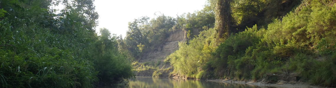
Components of a Sustainable Watershed
Good Water Quality
Creeks and rivers with good water quality have very low levels of pollutants and contaminants. They are safe for recreation such as swimming and kayaking and are a healthy home for wildlife.Healthy Riparian Habitats
A healthy riparian habitat contains native vegetation that acts as a buffer that filters out pollutants before they enter creeks or streams. Healthy riparian habitats are also able to support a diverse array of native animal species.Healthy Aquatic Habitats
A healthy aquatic habitat provides a safe home for aquatic animals that live in our watershed. A healthy aquatic habitat is free of pollution and contains a variety of areas for animals to live.Sustainable Stormwater Infrastructure
In a sustainable watershed, low impact development (LID), green infrastructure, stormwater parks, innovative parking paradigms, and other technologies and policy actually reduce the amount of taxpayer funded infrastructure that is needed.
San Antonio River Basin LID Technical Design Manual Content Overview
The manual addresses the design, specifications, and details of individual LID best management practices (BMPs). Since future maintenance should be considered during the design process, preferably by incorporating maintenance staff into the planning and design process, the manual also includes maintenance guidance. The manual provides guidance both on design considerations influenced by maintenance and on general maintenance practices for each BMP.
The manual also provides a segment on treatment trains, showing three different popular configurations of BMPs working in sequence for enhanced performance. Multiple treatment processes in either individual or multiple BMPs are called a treatment train. Treatment trains maximize the treatment of pollutants within the runoff. For example, vegetated filter strips designed to convey runoff from a road may be directed into an infiltrating bioretention cell that is designed to capture pollutants and provide volume reduction. Another example is the use of manufactured products for pre-treatment, filtering, trash removal, and oil and grease removal as the first structural BMP in a treatment train. Developer flexibility is enhanced by the many treatment train BMP combinations that can be designed.
San Antonio River Basin LID Technical Design Manual
Additional LID Design Resources
Natural Channel Design Protocol Manual
The purpose of this manual is to provide a Standard Operating Procedure (SOP) and Standard of Care criteria guidance for performing natural channel design projects in the San Antonio Region. The manual is intended for the engineering community, San Antonio River Authority (River Authority) staff, and all public and private entities within the River Authority four-county jurisdiction of Bexar, Wilson, Karnes and Goliad counties engaged in such projects.
LID Training Program
The San Antonio River Authority administers a training program in partnership with Bexar County for permanent on-site stormwater Best Management Practices (BMPs) including Low Impact Development (LID) practices and detention ponds. The training program is comprised of five courses offering continuing education and professional development hours, with three of the courses offering an exam credential. The program includes training courses for LID site planning and design, and credential courses for LID construction inspection, LID annual inspection/maintenance, and detention pond routine inspection/maintenance.
Site Planning for LID Course
The Site Planning for LID Course provides the knowledge, expertise and skills required for implementing the steps necessary for developing final site plans that incorporate LID including the design phases of site assessment and preliminary site design as described in the San Antonio River Basin LID Technical Design Guidance Manual. Siting and selecting appropriate LID practices is an iterative process that requires comprehensive site planning with careful consideration of site characteristics.
Design of Common LID Practices Course
The Design of Common LID Practices Course provides the knowledge, expertise and skills required to design the most common LID permanent stormwater management practices in the San Antonio region including bioretention, bioswale, permeable pavement, stormwater cistern and manufactured systems.
LID Construction Inspection Certificate Course
The LID Construction Inspection Certificate Course focuses on key factors of LID BMP construction inspection to ensure proper functioning at the time of construction. The LID BMPs addressed in the course include bioretention/bioswales, permeable pavement, sand filters, green roofs, vegetated swales, vegetated filter strips, stormwater wetlands, stormwater cisterns, and extended detention basin.
LID Annual Inspection & Maintenance Certificate Course
The LID Annual Inspection and Maintenance Certificate Course focuses on post-construction inspection and maintenance activities to ensure proper functioning of select permanent on-site stormwater BMPs. The LID BMPs addressed in the course include bioretention/bioswales, permeable pavement, sand filters, green roofs, vegetated swales, vegetated filter strips, stormwater wetlands, stormwater cisterns, and extended detention basin.
DETENTION POND ROUTINE INSPECTION & MAINTENANCE CERTIFICATE COURSE
The Detention Pond Routine Inspection and Maintenance Certificate Course focuses on post-construction inspection and maintenance activities to ensure proper functioning of detention ponds to meet Bexar County permit requirements.
Sign Up for the Mailing List!
Water Quality Modeling Tools
A key component to holistic watershed master planning and stormwater management is the identification and implementation of best management practices (BMPs) and low-impact development (LID) strategies to address urban runoff pollution.
Until now, the selection of BMP and LID strategies has been limited to qualitative planning, hindering the planners’ ability to discern effective BMP/ LID practices without long-term monitoring. Consequently, the San Antonio River Authority (River Authority) lead the development of several innovative water quality modeling tools to allow quantitative water quality master planning and BMP/LID prioritization for three major watersheds in the San Antonio River Basin.
The River Authority project earned a Gold Medal in the 2016 American Council of Engineering Companies (ACEC) Texas Engineering Excellence Awards, and an ACEC National Recognition Award.
River Authority Water Quality Modeling Standards
River Authority Load Reduction Tool
River Authority Enhanced BMP Tool
River Authority Timeseries Utility
River Authority Water Quality Modeling Tools Disclaimer
The suite of Water Quality (WQ) Modeling Tools developed by the San Antonio River Authority (River Authority) includes the WQ Modeling Standards, The Timeseries Utility Tool (TUT), The Load Reduction Tool (LRT), The Enhanced Best Management Practices (BMP) Tool and associated BMP Tool Database, the Simulation Manager, and the BMP Processor/Reporter Tool. These tools are provided as a courtesy by the River Authority, in order to help the River Authority stakeholders and the general communities better evaluate WQ conditions and select/evaluate BMPs and Low Impact Development (LID). The River Authority does not represent or warrant that these tools are appropriate or will work properly for any specific project. Use of the River Authority Tools is at your own risk, and you agree that you will hold the River Authority harmless from any losses you suffer related to the use of the River Authority Tools. Any modification or reuse of the River Authority WQ Modeling Tools will require prior written permission from the River Authority.
Threats to a Watershed
Loading..........
The Data is Not Available
What is Stormwater Runoff?
Stormwater is rain that falls onto impervious cover, such as streets, roofs, and driveways, picks up pollutants that are on those surfaces, and carries the pollutants into the street storm drain system and on into our streams. Those pollutants include, but are not limited to, oil, fertilizers, bacteria, heavy metals, gasoline, and sediment. A great stormwater control measure in highly urbanized areas, such as San Antonio, is low impact development (LID).