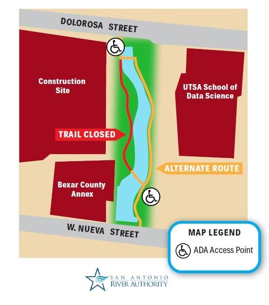
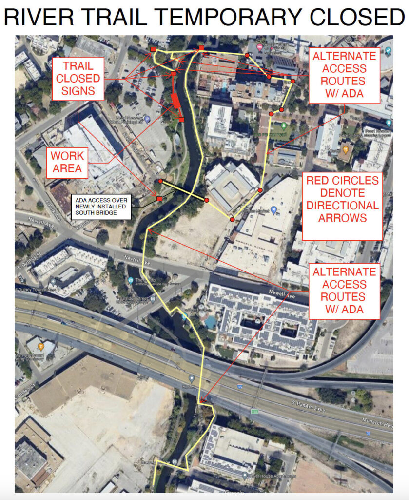
The San Antonio River Authority is a long-time user and advocate of Geographic Information Science/Systems (GIS) technology and solutions and continually strives to enhance and promote GIS within the agency and community. Learn more about the GIS resources that are currently available from the San Antonio River Authority by exploring the viewers and information featured here.
Questions? Be sure to visit our Frequently Asked Questions section at the bottom of the page.
Agency Interactive Viewers
Whether you are sitting at a desk or strolling along the River Walk, interactive GIS viewers are capable of displaying large amounts of data in an attractive, engaging, and user-friendly format. It’s easy to understand why they are a popular tool among GIS users of all skillsets! Learn more about the various projects and initiatives led by or involving the San Antonio River Authority by exploring the viewers featured below.
This application provides basic information about the various floodplains located throughout Bexar, Wilson, Karnes, and Goliad Counties. The data used in the application was collected by San Antonio River Authority and its partners. The ‘draft’ floodplains displayed are under FEMA review to be formally adopted.
Explore
Water Quality Viewer
The Water Quality Viewer displays the monitoring efforts for the Texas Commission on Environmental Quality (TCEQ) Clean Rivers Program and summarizes how the water quality in the San Antonio River Basin compares to the Texas Surface Water Quality Standards (TSWQS) using the latest TCEQ Integrated Report assessment.
Explore
Bacteria Dashboard
The River Authority tracks the bacteria Escherichia coli (E. coli) throughout the San Antonio River Watershed, and created this dashboard to display multiple visualizations of the most current monitoring station information.
Explore
Watershed Master Plan Viewer
Explore
GIS Open Data
The San Antonio River Authority allows access and use of its data and maps as a public service. This Open Data website allows the public to download San Antonio River Authority’s maps and data. These maps and/or data are to be used for reference and/or informational purposes only and may not have been prepared for or be suitable for legal, engineering, or surveying purposes. It does not represent an on-the-ground survey and represents only the approximate relative location of property boundaries.
Frequently Asked Questions
Great question! The RiskMAP Viewer is a great tool to view where your personal property is located in relation to FEMA-designated flood zones and hazard areas. In addition, the Floodplain Viewer can provide valuable insight on local and regional flood hazards.
For more data and information concerning flood zones, please refer to Federal Emergency Management Agency (FEMA) Flood Map Service Center website.
Yes! Please visit our open data website, ExploreSARA, to view the data that is currently available for download. If you don’t find what you need on ExploreSARA, please go to TxGIO for more information or Contact Us.
Select LIDAR data is available for download on our open data LIDAR portal. If you are in need of data that is not featured on the portal, please go to TxGIO for more information or Contact Us.
Select elevation and terrain contour information for Bexar, Wilson, Karnes, and Goliad Counties is provided on our open data LIDAR portal.
Please go to The River Authority’s Digital Data and Modeling Repository (D2MR) website. There is a general viewer to see where data is available, but a login is required to download it. Simply register on the homepage if you do not have a username and password.
Other GIS Data Sources
For all information and GIS data related to floodplain and watershed management but not maintained by the San Antonio River Authority, please refer to the following local, regional, state, and national entities.