Last Updated on January 30, 2024
As the Authority on flood safety, keeping lives, property, and our natural environment safe and secure from the devastating effects of major flooding is a top concern for the San Antonio River Authority (River Authority). The River Authority is meeting the challenge with comprehensive planning, precision protection, strategic partnerships, and community preparedness.
Along with maintaining over 40 dams and other flood control structures, the River Authority also advocates for development techniques designed to reduce runoff and improve water quality. In today’s blog, learn more about what the River Authority does regarding flood safety and how you can be prepared before, during, and after a devastating flood.
BEXAR COUNTY DRAFT FLOODPLAIN MAPS & PUBLIC MEETINGS
As a cooperating technical partner for the Federal Emergency Management Agency (FEMA), the River Authority invites you to view the Bexar County draft floodplain maps. The River Authority is taking the initiative in sharing these maps with the community ahead of FEMA’s formal map adoption process. Attendees will have the opportunity to look up any property of interest within the County on the draft map alongside a River Authority engineer. In addition, City of San Antonio staff and representatives from other government agencies will be available to answer questions on flood insurance, floodplain regulations, and upcoming or potential projects relating to flooding/drainage in the area. Learn more about these maps and find a public meeting near you.

Don’t Drown in Doubt: Tips for flood preparedness
The River Authority cares about your safety. Read the tips below to get yourself, your loved ones, and your property prepared before the next flood.
BEFORE A FLOOD, you should:
Prepare a family disaster plan. This includes the following:
- Make an itemized list of personal property and photograph the interior and exterior of your home.
- Keep insurance, important documents, and other valuable items in a safe deposit box.
- Make a keep-in-touch arrangement with relatives and friends.
- Assemble a disaster supplies kit.
Find out where you can go if ordered to evacuate.
- Plan places where you and your family will meet both in and outside your neighborhood and become familiar with alternate routes to get there.
Assess your need for flood insurance.
- Speak with your home insurance provider, keeping in mind that flood insurance is separate from home insurance.

San Antonio River flooding in 1998.
DURING A FLOOD, you should:
Stay informed.
- Keep updated with www.BexarFlood.org, which provides current flood information and emergency road closures.
- Listen to local radio and TV outlets.

Get to higher ground.
- If you live in a flood-prone area or are camping in a low-lying area, get to higher ground immediately.
- Avoid areas subject to flooding: dips, low spots, floodplains, low water crossings, etc.
Obey evacuation orders.
- If told to evacuate, do so immediately. Lock your home when you leave. If you have time, disconnect utilities and appliances.
- If forced to leave your property and time permits, move essential items to safe ground, fill tanks to keep them from floating away, and grease immovable machinery.
- Store a supply of drinking water in clean bathtubs and in large containers.
- Return home only when authorities say it is safe.
Turn around, don’t drown!
- Do not attempt to drive over a flooded road. STOP! Turn around and go another way.
- Never try to walk, swim or drive through such swift water.
- Keep children from playing in floodwaters or near culverts and storm drains.

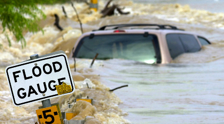
Flooding at 281 and Jones Maltsberger Rd. in San Antonio, TX
AFTER A FLOOD, you should:
Pay attention to authorities for information and instructions.
Take care of your basic needs.
- Contact your local health department to find out if a boil water notice has been issued.
- If fresh food has encountered floodwaters, throw it out.
- Seek necessary medical care at the nearest hospital. Food, clothing, shelter, and first aid are available at American Red Cross shelters.
Take precautions when cleaning up.
- Use flashlights, not candles or fuel lanterns, to examine buildings. Flammables may be inside.
- Wear proper protective equipment during cleanup.
- Do not handle live electrical equipment in wet areas. Electrical equipment should be checked and dried before being returned to service.
Following these flood preparedness tips will help keep you and your loved ones safe. The River Authority wants the community’s interactions with the watershed to be positive as the agency continues its commitment to safe, clean, and enjoyable creeks and rivers.
Request a community presentation
Learn more about the River Authority’s efforts to keep our communities safe. Together, we can all do our part to make safety a priority.