Last Updated on March 6, 2026
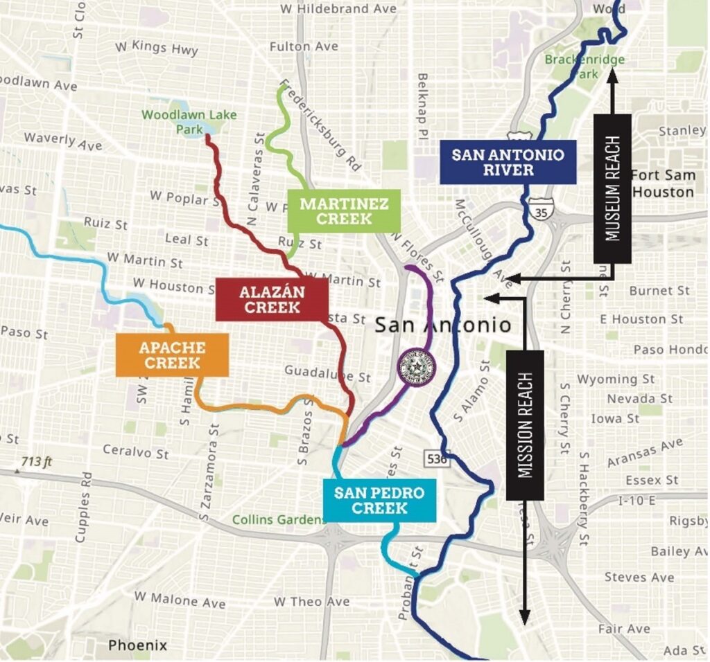
The Westside Creeks Ecosystem Restoration Project includes the light blue, orange, red, and green portions of San Pedro, Apache, Alazán, and Martinez Creeks.
If you have lived anywhere in or near the Westside of San Antonio over the past 15 years, you have probably heard of the elusive Westside Creeks Ecosystem Restoration Project. So, what is it, and why is it taking so long? In a nutshell, the San Antonio River Authority (River Authority), local project supporters, and elected officials have been urging the project to receive federal funding for a decade. Now, funding has been secured from within the United States Army Corps of Engineers (USACE) portion of the Bipartisan Infrastructure Law, a project team has been put together, and design is finally getting underway.
November 15, 2022—Members of the public chat with River Authority staff at a Westside Creeks Ecosystem Restoration Project Community Information Meeting. The next meeting will be held on July 22, 2023.
Why is the project taking so long?
Knowing a little bit of history helps explain where we are today. In 1954, the USACE approved the San Antonio Channel Improvement Project (SACIP), which straightened and channelized approximately 31 miles of the San Antonio River and Westside Creeks to help alleviate flooding in the San Antonio River Basin. Several projects stem from the SACIP, including the San Antonio River Tunnel that protects downtown from flooding, the ecosystem restoration of the Mission Reach, and the channelization of parts of the Westside Creeks. Local partners and the USACE have carried out additional projects stemming from SACIP by staying true to the original mission and within the project boundaries. The San Antonio River Authority (River Authority) requested USACE to study the Westside Creeks area to determine if restoring the aquatic and riparian creek habitats that were negatively impacted through the earlier channelization would be feasible. USACE published a favorable report which included community input in January 2014.
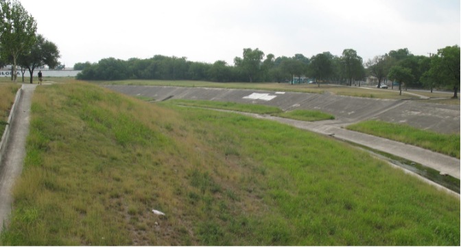
Concrete channelization from a flood control project along Apache Creek can be seen.
As we shared in the introduction, since the report’s publication in 2014, the River Authority and local partners have advocated for the Federal Government to fund the project. Locally the sentiment was when the project would begin rather than if the project would happen at all. In anticipation, the City of San Antonio started constructing trails along the creeks as a part of the Howard W. Peak Greenway Trail system. Bexar County had already committed to being the local funding partner taking on the required 35% local cost share. Then, in early 2022, good news arrived: the River Authority was excited to announce full federal funding had been allocated for the project by the USACE.
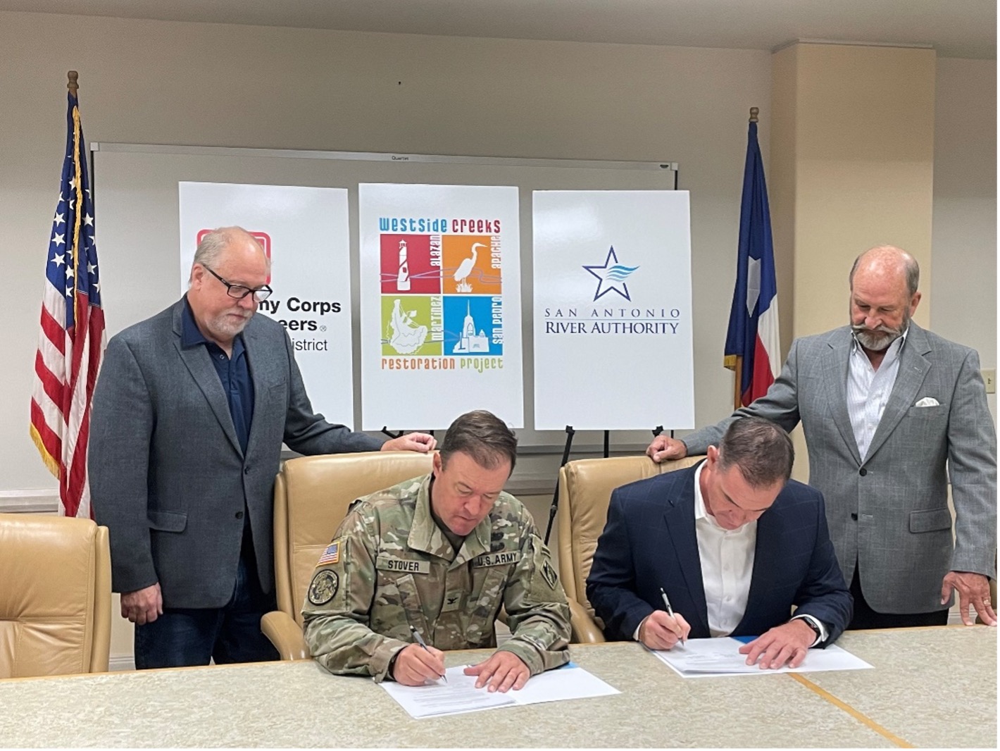
Deputy District Engineer for Programs and Project Management Eric Verwers (far left) and River Authority Board Chairman Jim Campbell (far right) look on as Commander of the USACE, Fort Worth District, Colonel Jonathan Stover and River Authority General Manager Derek Boese sign the Project Partnership Agreement.
What is the current timeline for the Westside Creeks Ecosystem Restoration project?
USACE has brought on an architectural and engineering firm to begin the project design. While design and construction sometimes overlap, the first few years will focus solely on design. Construction is estimated to start in late 2025 and carry through 2029.
What will be included in the project?
The project will resemble the Mission Reach Ecosystem Restoration and Recreation Project. While the goal of restoring the creeks to a more natural state is the same for both project areas, the environment and community are different–more like cousins rather than twins. Using ecosystem restoration and recreation benefits as a foundation, the project will provide significant environmental justice and community benefits. This will be demonstrated by improving the environment and water quality conditions in a densely populated urban area, promoting comprehensive watershed management, advancing neighborhood transportation safety, providing access to outdoor recreation activities in the Westside core, and reconnecting residents to urban waterway systems through an outdoor living classroom for students of all ages.
How can the public get involved?
Attend or tune into the public stakeholder committee meetings for the project. The stakeholder committee, Westside Creeks Ecosystem Restoration Committee (WCROC), meets every other month. Meetings are hybrid with in-person attendance at the San Antonio River Authority offices. Details for attending virtually can be found by visiting the events section of the Westsidecreeks.com website or by signing up for email notifications.

Provide us with direct feedback on what you would like to see as a part of the project by attending a Community Involvement Session on Saturday, July 22, from 9 AM to Noon at Tafolla Middle School cafeteria. Attendees can provide feedback on features they would like to see as a part of the project and where they want to see them located. In addition, there will be additional activities like a touch tank of animals from the San Antonio River, a 3D model of the San Antonio River Watershed, a children’s coloring activity, and complimentary refreshments. We hope you can join us!
Stay up to date on similar opportunities for involvement in this project by signing up for email notifications on the left side of westsidecreeks.com.