Mission Reach Prescribed Burns

Written by:

Posted on:

Categories:

Share:

Facebook
Twitter
LinkedIn
Email

Get The Latest:

Join our print or digital newsletter to be informed about the agency’s many projects and other news.

Educational sign placed after a prescribed burn on the Mission Reach

Last Updated on March 31, 2023

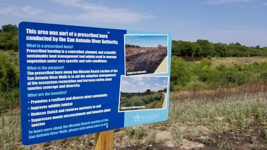
As part of our commitment to safe, clean, enjoyable creeks and rivers, the San Antonio River Authority (River Authority) maintains more than 500 acres of parks along the San Antonio River’s 240-mile course. Our Watershed & Park Operations staff uses prescribed burning as a land management tool to help maintain the Mission Reach Ecosystem Restoration and Recreation Project along the San Antonio River Walk.

Read along to learn more about this adaptive management method and the benefits it provides to the native habitat!

What are the benefits of prescribed burning?

Prescribed burning is a controlled, planned, and scientific land management tool widely used to manage excessive vegetation under very specific and safe conditions. Native plant communities, and particularly grassland systems, can benefit from periodic, low-intensity fires and other natural processes that reduce competition from taller plants and trees. Land managers use fire ecology for restoration purposes through prescribed burning.

When used as part of an adaptive management program, prescribed burning can result in an overall healthier landscape by removing dead pant material, restoring nutrients to the soils, and suppressing trees as well as some non-native species.

River Authority Prescribed Burn Process  

The River Authority staff conducted the first prescribed burn on the Mission Reach of the San Antonio River Walk in June 2018 and has continued to do so on a regular schedule. “Cool” season burns, or burns that are conducted in the winter, are more likely to help promote the growth of native species whereas “warm” season burns, or burns conducted in the summer, are used more to suppress growth of non-native species.

In preparation for the initial prescribed burn in June 2018, the River Authority contracted a licensed and certified prescribed burn management company and received approval from the local fire department. The River Authority also conducted public outreach to educate and inform the public through traditional and social media efforts as well as held public meetings targeted at the neighborhoods adjacent to the prescribed burn area site.

On the day of the prescribed burn, weather conditions are checked as high winds and rain can affect whether the team can proceed or not. If conditions are ideal, then trail closures are placed in effect along with signage to educate the public and offer detour options. The burn is supervised by River Authority staff along with the licensed contractor and the local fire department. After the burn is completed, temporary educational signage is placed on the prescribed burn site to educate the public about what took place.

River Authority staff is currently working on this year’s prescribed burn sites as we continue to use this adaptive management method on the Mission Reach as part of a regular operations and maintenance schedule. Having conducted several prescribed burns since June 2018, we no longer hold public meetings prior to doing the controlled burn. We do continue to inform the public of upcoming prescribed burns using traditional and social media. Follow our social media channels to learn more and see photos of the upcoming sites!


Related Articles

Alerts

Mission Reach Area Maintenance

Mission Reach Area Maintenance

*MARCH 2026 UPDATE*

Ongoing stem-density maintenance is currently taking place in this area. Crews will be working Monday through Friday during daytime hours. We appreciate your patience as we complete this important work to maintain and enhance the park for everyone to enjoy.

When: Beginning October 20, 2025 through Spring 2026
What: Crews will be performing stem-density removal and related vegetation maintenance along sections of the Mission Reach to help manage flood risk and protect surrounding infrastructure. Some trails or segments may be closed temporarily while work is underway.
Why: Removing excess stems that naturally establish along the river helps maintain stormwater conveyance, reduces flood risk, and protects public infrastructure while allowing grassland and native vegetation to recover and thrive.
What to expect:

  • Limited trail closures and intermittent work zones.
  • Crews and equipment working near the riverbanks during daytime hours.
  • Parking areas remain open, but visitors may see signage and temporary barriers.

Questions? Call the San Antonio River Authority at (210) 227-1373 or visit https://www.sariverauthority.org/services/river-health/ecosystems/.

Thank you for your patience while we keep the Mission Reach safe, clean, and enjoyable.

San Pedro Creek Culture Park

The east bank trail along San Pedro Creek will be temporarily closed between the upper trail at Cameron St. and the lower trail at two access points.

Closure details:

  • The first closure will impact the connector from the upper trail near West Houston St. to the south lower San Pedro Creek trail.
  • Once work at this location is complete and the trail reopens, construction will shift to the second closure area between the upper and lower trails on the opposite side of the green space.

Please follow posted signage and plan alternate routes. We appreciate your patience as this work is completed.

Closed areas around San Pedro Creek Culture Park

The Brackenridge Trail

Trail Lighting Notice – Brackenridge Park Trail

Due to an electrical issue, lighting is currently out along the north portion of the trail, from the Josephine Street inlet to just past Highway 281 within the Brackenridge Park Trail. Our team is actively working to correct the issue and expects repairs to be completed by the end of business tomorrow.

We apologize for any inconvenience this may cause and appreciate your patience as we work to restore lighting. Please use caution when traveling through this area, especially during evening hours.

Trail Closure Alert – Calder Alley, San Pedro Creek

Maintenance work will be done in Calder Alley starting Wednesday, September 18, 2025.

  • Trails will remain open during this work.
  • One bench at a time will be temporarily barricaded while improvements are completed.
  • There may be occasional contractor pickups in the area.

We appreciate your patience as we continue to maintain and improve San Pedro Creek for all to enjoy!

SASPAMCO Paddling Trail

The SASPAMCO paddling trail is open from River Crossing Park to Helton Nature Park.
*Please Note: Paddling Trail from Helton Nature Park to HWY 97 is still closed due to blockages. 

SASPAMCO Paddling Trail Temporarily Closed

Staff have removed two large log jams just downstream of Helton Nature Park, keeping the southern portion of the SASPAMCO Paddling Trail temporarily closed. Staff are working to contact adjacent landowners to support a land-based removal solution.

Goliad Paddling Trail Alert

NOTICE: HWY 59 Landing Site Closed

Due to TxDOT construction on the HWY 59 Bridge, the HWY 59 landing site is closed until further notice. However, the Goliad Paddling Trail remains open, and paddlers can still access the river at the Riverdale, Ferry Street, and Goliad State Park landings.

Please plan accordingly and check back for updates.

River Reach Newsletter and Blog Signup

River Reach is offered as a printed, physical mailing to your residence or business. The Blog is a weekly electronic email with news and updates in order to be more environmentally conscious. Please fill out the form below and indicate your preferred method of delivery.

By submitting this form, you are consenting to receive marketing materials from: San Antonio River Authority, 100 East Guenther St., San Antonio, TX, 78204, US. You can revoke your consent to receive emails at any time by using the SafeUnsubscribe® link, found at the bottom of every email. Emails are serviced by Constant Contact. This site is protected by reCAPTCHA and the Google Privacy Policy and Terms of Service apply.