The San Antonio River Basin Interactive Green Infrastructure Map provides a place to share Green Infrastructure projects funded by the San Antonio River Authority, access resources, and learn how you can participate. Together, we are all making a difference.
Since 2014, the San Antonio River Authority (River Authority) has provided incentives such as rebates for the creation of green infrastructure features. The River Authority has also created an interactive green infrastructure dashboard (below) that provides information about the amount of stormwater and select pollutants that the features manage.
Green Infrastructure 101
Stormwater runoff is the greatest threat to river health in the San Antonio River watershed with many other US communities reporting the same problem. Unlike pollution from an industrial pipe, which can be traced to its source, stormwater runoff can originate from anywhere within our watershed such as parking lots, rooftops, unsecured construction sites, roadways, and even our own yards. In urban areas, runoff is designed to be carried from these surfaces to the storm drain system and then directly to a nearby river, creek, or stream.
In our watershed, stormwater runoff is not cleaned at a treatment plant before being discharged into the environment. Pollutants like oil, grease, metals, bacteria, sediment, fertilizers, pesticides, pet waste, and thermal pollution accumulate on the surfaces. During rains, runoff carries the pollutants to our creeks and rivers and during hard downpours, runoff can contribute to street and neighborhood flooding. Stormwater runoff prevents creeks and rivers from primary and secondary contact recreation during and for approximately 72 hours after rain events. Over time, surges of runoff from urbanized areas erode creek banks and can negatively affect bridge and other community infrastructure.
Green infrastructure is a design and land development approach that alleviates these negative runoff impacts. Bioretention systems, stormwater cisterns, permeable pavement, buffers, retention of native infiltrative soils, green space preservation, natural channel (river) design, and several other sustainable development approaches perform natural or nature-mimicking functions that slow, capture, and/or clean stormwater runoff—like nature intended. The design and installation of green infrastructure meets our goals of reducing local flooding and improving water quality by mimicking natural areas to slow, detain, and filter stormwater.
Unlike a storm drain and concrete-lined river segment, which are designed for the singular purpose of water passage, green infrastructure provides multiple benefits.
Along with reducing neighborhood flooding and pollution in our creeks and rivers, green infrastructure benefits include:
- reducing the heat island effect
- improving human health
- creating or preserving valuable wildlife habitat, including for monarchs, bees, and other pollinators essential to our human food supply
Green Stormwater Infrastructure Legend
- Treated Stormwater Volume is the volume of stormwater treated by Green Infrastructure methods to improve water quality, using one or more processes: infiltration, filtration, pollutant settling, or bioremediation. Treated Stormwater Volume is measured in cubic feet (1cubic foot = 7.5 gallons).
- Bioretention, called rain gardens, are shallow landscaped areas designed to slow and clean stormwater runoff, reduce local flooding, and protect stream health.
- Bioswales are shallow vegetated drainage paths that soak up and filter stormwater runoff from roofs or pavement. Bioswales are constructed with quick-draining soil and drainage layers to filter stormwater and provide water for plants.
- Cisterns are containers that store primarily roof runoff, keeping stormwater on-site during storms to mitigate flooding and often used later for supplementary watering.
- Permeable Pavement is a load-bearing paving method that allows for infiltration, on-site storage, and settling of stormwater pollutants to clean and reduce runoff during a storm.
- Sediment are fine particles suspended in stormwater. Sediment from stormwater makes streams and rivers appear cloudy which affects the health of all river plants and animals. Other pollutants such as nutrients, metals and bacteria attach to sediment and are deposited at the stream bottom where they can harm plants and animals.
- Bacteria measures fecal coliform bacteria which is measured in number of colonies. Fecal coliform is used as an indicator of contamination with other pathogens which cause disease in humans. When bacterial levels are high, human contact can result in sickness. Reducing bacteria makes the river safe for contact activities.
- Green Roof are rooftop planted areas that reduce or eliminate runoff leaving the roof through stormwater capture, plant uptake, and evapotranspiration.
Green Infrastructure Master Plan
Through Clean Water Act Section 319(h) Grant Funding from the Environmental Protection Agency (EPA), the Texas Commission on Environmental Quality (TCEQ) and the San Antonio River Authority (River Authority) have entered into the Upper San Antonio River Watershed Protection Plan (WPP) Implementation – Green Stormwater Infrastructure Master Plan contract.
The San Antonio River Authority (River Authority) was awarded a Clean Water Act Section 319(h) Grant by the U.S. Environmental Protection Agency, administered by the Texas Commission on Environmental Quality (TCEQ) to develop a master plan for the use of green stormwater infrastructure (GSI). This grant project builds off recommendations made in the Upper San Antonio River Watershed Protection Plan (WPP) to implement GSI to reduce stormwater runoff pollution and addresses measures in the Texas Non-Point Source Management Program.
Traditional stormwater infrastructure is designed to manage stormwater volume, not stormwater quality. GSI are constructed features that add the stormwater quality component by mimicking the predevelopment hydrology of an area. Examples are bioretention basins (called rain gardens) and swales, extended detention basins, constructed wetlands, vegetated filter strips, cisterns, and permeable pavement and pavers. They are designed to clean and reduce local flooding by capturing and treating stormwater runoff pollution before it enters local creeks and rivers.
Since GSI is still relatively new to the San Antonio River Basin (SARB), the Master Plan aims to guide decision-makers on where and how to apply limited resources in the upcoming years to maximize water quality benefits while addressing local flooding concerns. The River Authority incorporated stakeholder input to identify and build on common goals and investment priorities for implementing GSI.
The River Authority’s watershed scale models have identified sub-basins or small watersheds that have the highest stormwater pollutant load reduction potential. This project used existing data and modeling tools to identify and prioritize sites within those areas that have the highest potential for GSI implementation effectiveness. Properties considered for implementation included public lands, schools, capital improvement projects, city planning areas, and neighborhoods with supportive stakeholders such as homeowner’s association partners.
For the recommended sites, the River Authority developed site-scale models, concept-level designs, and GSI cost estimates. Using an existing model, the River Authority estimated the pollutant load reductions these projects would achieve across the watershed. The GSI Master Plan will include a recommended schedule of implementation, the stakeholder process, costs, funding considerations, and the overall evaluation and prioritization process – all as examples communities can use for their own decision-making. The GSI Master Plan will also include an evaluation of Triple Bottom Line (TBL) benefits (social, environmental, economic). Ultimately, the goal is for the GSI Master Plan to become a template for all sub-basins not meeting water quality standards in the SARB.
Guenther and Euclid Retrofit
Through Clean Water Act Section 319(h) Grant Funding from the Environmental Protection Agency (EPA), the Texas Commission on Environmental Quality (TCEQ) and the San Antonio River Authority (River Authority) have entered into the Upper San Antonio River Watershed Protection Plan (WPP) Implementation – Green Stormwater Infrastructure Master Plan contract.
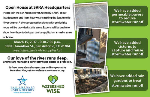
The Guenther and Euclid Stormwater Retrofit Project allows the River Authority to implement demonstration stormwater retrofits. The low impact development (LID) best management practices (BMPs) utilized for this project are identified in the Upper San Antonio River WPP.
The San Antonio River Basin’s primary source of pollution is non-point stormwater runoff. Low Impact Development is a sustainable land planning and design approach that manages stormwater on site using permanent stormwater BMPs. LID treats small, frequent storm events on-site with a focus on “first flush” pollutants. These are pollutants such as oils, pesticides, E. coli bacteria, and other constituents that, under a traditional site-to-street-to-stormdrain-to-creek stormwater conveyance system, wash off hardened surfaces and into our streams. LID also reduces the volume of runoff generated on a site, thereby reducing pollutant loading to the waterbody.
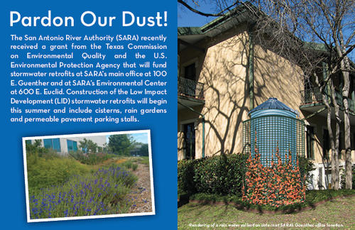
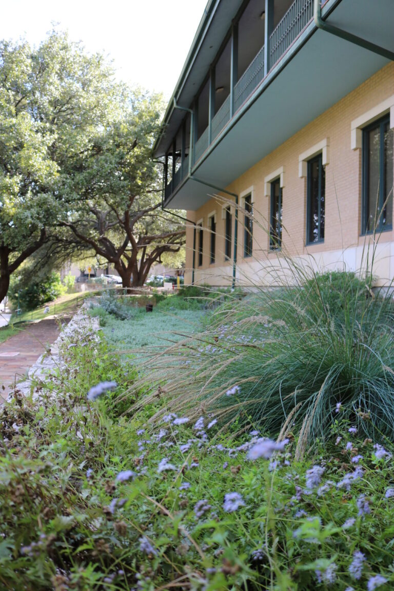
Demonstration BMPs were constructed in accordance with the River Authority’s LID Technical Guidance Manual, and provide case studies of highly urbanized construction retrofits. At the River Authority’s headquarters on 100 E. Guenther St., permeable pavers, bioretention areas, and cisterns address pollutant export that flows directly into the San Antonio River. At the River Authority’s Environmental Center, 600 E. Euclid Ave. two 22-foot tall cisterns were added to collect two-thirds of the building’s rooftop runoff and are used in an onsite irrigation system.
The demonstration BMPs installed through this project have become a public education tool on how retrofits and LID can reduce storm water runoff and non-point source pollution.
Learn more about LID feature construction in these videos:
Public Outreach Timeline