The San Antonio River Authority owns, maintains, and/or operates assets in the San Antonio River Watershed which covers Bexar, Wilson, Karnes, and Goliad counties including dams, parks, and wastewater treatment plants. The parks include the San Pedro Creek Culture Park as well as the Museum and Mission Reach segments of the River Walk. It also includes several nature-based parks located throughout all four counties.
If you are looking to develop adjacent to the Museum (RIO-2) or Mission Reach (RIO-5 and RIO 6) or the San Pedro Creek Culture Park (RIO-7), the City of San Antonio Unified Development Code requires formal coordination with the River Authority as part of plats and building permits. Coordination with the River Authority might also be needed in RIO-1 (San Antonio River north of 281) and RIO-4 (West Durango Boulevard to Mission Road).
River Walk and San Pedro Creek Development
If you are considering development adjacent to the River Walk or San Pedro Creek, you will be required to coordinate with the San Antonio River Authority per the City of San Antonio’s Unified Development Code 35-673.
As part of the coordination, the River Authority requests that the developers provide information on their development in the preliminary phases. For most projects, the River Authority will want a full set of plans and specifications. Earlier coordination is better.
Below is a list of typical items that the River Authority will want information on regarding your development. This is not an all-inclusive list.
Water Quality
- Control and care of storm water
- LID features
- Type and size
- Stormwater not allowed to flow onto River Walk park
- Any other water producing areas
- Pools
- Parking areas
- Dog yards
- HVAC/process
- Environmental reports
- Soils that, if disturbed, may get into water
Property Lines
- Verification of property lines
- Right of entry for construction
- Easements, if needed
Landscape and Hardscape
- Tie in to existing park
- Appropriate to area and size of development
- Minimal disruption of existing park hardscape
- Plant selection
- To reduce invasive species in park
- Matching materials
- Stone/concrete/other
- Establishment of maintenance boundaries
Scheduling
- Park interruptions
- Trail Closures
- Detours
- Public notification
Existing Infrastructure
- Pipe size
- Below water line tie unless water feature
- Irrigation and electrical in park
In Stream / River Activity
- New storm sewer connections
- Plugging storm sewer connections
- Coffer dams
Trail Closure Procedures
If you are proposing to perform work on the Museum Reach, Mission Reach or San Pedro Creek that will impact the trail system, you will need to comply with the City of San Antonio’s Unified Development Code 35-673 (c) (8) a. iv which requires coordination with the San Antonio River Authority (River Authority). The River Authority recognizes that these trail systems are heavily used and strives to minimize public inconvenience while working with developments adjacent to Museum Reach, Mission Reach and San Pedro Creek Culture Park.
You will need to obtain a permit or license from the River Authority. Submission of a completed application and payment of associated costs does not guarantee that a permit or license will be issued. If work is completed earlier than anticipated a refund will be issued for the days that were not used for the trail closure. Please allow 10 business days for review of your application. Trail closures are granted on a first come, first serve basis and are limited to six months.
Send Permit Applications to: River Authority Developer Resources, email, 210-302-3666
Payment is currently accepted by check: Please make your check payable to the San Antonio River Authority. Payments are accepted at the River Authority Environmental Center, 100 E. Guenther, San Antonio, TX 78204-1401.
- Intermittent Closure – Impacted with maintenance or equipment and will have flaggers at all times to temporarily (less than 2 minutes) hold traffic or guide traffic around the equipment.
- Signage may be required, at the River Authority’s discretion.
- Provide a narrative of the closure, how the construction will safely take place and how the public will be protected.
- Partial Trail Closure – Minimum width 5 feet must be open. Must only impact a 20 foot long area or less.
- Manual of Uniform Traffic Control Devices (MUTCD) signage may be required, at the River Authority’s discretion.
- At least 5 feet of trail must be unobstructed.
- May only be 20 feet or less of impact to the trail.
- Provide a narrative of the closure and how the construction will safely take place and how the public will be protected.
- Full Trail Closure – A License Agreement will be required for a full trail closure. River Authority will provide site specific license agreements once the work is defined.
- Develop Temporary Signage plan in accordance with the Manual of Uniform Traffic Control Devices (MUTCD).
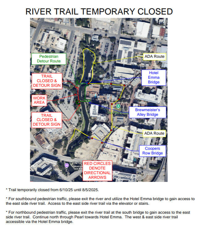
- Develop 24” x 36” map and mount on A-Frame. Permit will note areas that A-Frame map is required.
- Click here for a template
- Map should have work area clearly noted
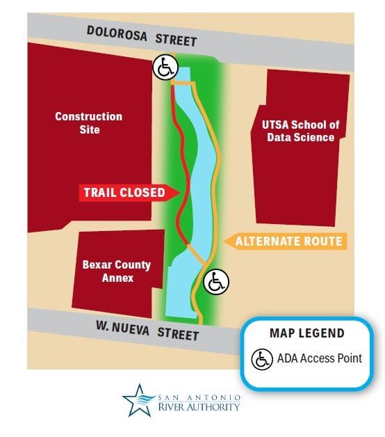
- Map should include an ADA access alternate route
- Map should have both the alternate route written out and mapped out
- Map should clearly explain the Trail closure from access point A to access point B. It is recommended that the trail closure be highlighted in red as seen on the example
- Signage should clearly explain the alternate route be highlighted in yellow
- Map needs to have a name and contact phone of individual responsible for the project should the public have questions.
- Map must have the River Authority’s logo at the bottom
- Map must be approved by the River Authority prior to printing
- License expense is based on linear footage of the area proposed to be closed to the public, and not the area where the work is proposed to occur.
Low Impact Development (LID)
The San Antonio River Authority, in conjunction with the City of San Antonio, sought inclusion of the new, voluntary LID/NCDP use pattern into the Unified Development Code (UDC).
- To eliminate the need for variances to utilize LID practices
- To add incentives to encourage use of LID practices, and
- To establish performance standards required to earn the incentives
The City of San Antonio also requested the River Authority to include amending the Conservation Subdivision use pattern in the project, again to provide greater incentives to make use of the code more attractive.
Under the amendment to Section 35-210, developers using LID/NCDP practices can qualify for two types of incentives: credit/offset-based and fee-based.
For new development, the first 1.5” of rainfall falling on the developed area during the 24-hour rain event shall be managed. For a redeveloped site, the first 1.18” of runoff in a 24-hour event shall be managed.
Credit/Offset
- If a minimum of 60% water quality volume (WQV) from increased impervious cover, then the applicant is eligible for the credit offset incentives in table 210-1 below.
- Applicants using LID/NCDP practices and managing less than 60% of the WQV shall be eligible for credit/offsets 1 through 4 in the table below.
- If less than 100 percent of the WQV is managed, first priority is to be given to managing runoff from parking and street areas within the development limits.
Table 210-1
Loading..........
The Data is Not Available
Fee-based
- Applicant managing a minimum of 60% of the WQV shall receive credit and offset incentives for LID/NCDP according to Table 210-2.
- Stormwater Fee Discount: Specified in Section 34-7.07.
- Stormwater Fee in Lieu of Discount: See Table 210-2.
Table 201-2
Percent of WQV Managed (Volume resulting from first 1.5'' in 24 hours on developed site)
Loading..........
The Data is Not Available
Permeable pavement shall not be counted as impervious cover if designed to store the 2-year, 24-hour storm event.
Development by a San Antonio River Authority Operated Dam
The San Antonio River Authority maintains and operates 28 dams in Bexar County and 13 dams in Karnes County. The structures are vital flood retarding structures that are designed to detain storm water for current existing conditions. If you are looking to develop near these dams, please email us or call 210-302-3666 to discuss your development’s impact on the dam.
Letter of Map Revisions (LOMR) Review Partner
The San Antonio River Authority (River Authority) has partnered with the Federal Emergency Management Agency (FEMA) as part of the Letter of Map Revision Delegation Program that enables the River Authority to review proposed revisions to floodplain maps within its four county jurisdiction. In its capacity as a FEMA Delegation Program partner, the River Authority is responsible for reviewing floodplain maps for revisions throughout Bexar, Wilson, Karnes and Goliad counties (including all incorporated communities). Those revisions are known as Letter of Map Revisions (LOMR) and Conditional Letter of Map Revisions (CLOMR). The River Authority officially began receiving submittals in 2012. By serving as a FEMA’s LOMR/CLOMR delegate, the River Authority is able to provide certain benefits to communities throughout its jurisdiction, including the following:
- Management of local engineering models, supporting data and floodplain maps;
- Local coordination of adjacent map revision request;
- Availability of local San Antonio River Authority staff to discuss submittals; and
- Knowledge of local area projects and issues that might impact current map and future revisions.
Mail or Deliver CLOMR/LOMR Submittals to:
San Antonio River Authority
Attn: Watershed Engineering Dept. LOMC Administrator
100 E. Guenther
San Antonio, TX. 78204
Contact Program Administrator
All MT-2 applications for C/LOMR submissions should no longer be sent directly to FEMA. All submissions for CLOMRs and LOMRs inside the geographic area of Bexar, Wilson, Karnes, and Goliad will be processed by the San Antonio River Authority. FEMA will maintain responsibility for the processing of MT-1 applications.
Resources and Links
Forms and Documents
Instructions
- Instructions for Completing Application for CLOMRs and LOMRs (PDF, 352KB, 05/13/2013)
- Procedure Memorandum No 57 (PDF, 434KB, 09/22/2010)
- Changes to FEMAs Appeals Process (PDF, 111KB, 09/22/2010)
Documents
- New CLOMR Procedure- Endangered Species Act (PDF, 219KB, 09/22/2010)
MT-2 Forms
- Alluvial Fan Flooding Form (PDF, 24KB, 09/22/2010)
- Coastal Structures (PDF, 87KB, 09/22/2010)
- Coastal Analysis Form (PDF, 78KB, 09/22/2010)
- Overview and Concurrence (PDF, 193KB, 09/22/2010)
- Payment Information (PDF, 66KB, 01/11/2011)
- Riverine Hydrology and Hydraulics (PDF, 94KB, 09/22/2010)
- Riverine Structures (PDF, 142KB, 09/22/2010)
MT-2 Notification Templates
- LOMR Letter Template (PDF, 57KB, 03/07/2013)
- CLOMR Letter Template (PDF, 53KB, 03/07/2013)
- Newspaper Notification Template (PDF, 53KB, 03/07/2013)