San Antonio River Authority Partners With Popular Waze App To Deliver Real-Time Low Water Crossing Alerts And Enhance Road Safety

Written by:

Posted on:

Categories:

Share:

Facebook
Twitter
LinkedIn
Email

Get The Latest:

Join our print or digital newsletter to be informed about the agency’s many projects and other news.

Flooding Car Submerged

Last Updated on January 4, 2024

(SAN ANTONIO, TX) – The San Antonio River Authority (River Authority) is pleased to announce a strategic collaboration with WAZE, the popular crowd-sourced navigation app, to provide real-time information on low water crossings through the WAZE platform. This initiative aims to improve road safety by leveraging community-driven data to alert drivers of potential hazards, ultimately saving valuable time and enhancing public safety.

WAZE, known for its innovative navigation solutions, partners with cities, transportation authorities, broadcasters, businesses, and first responders to integrate user-generated data into its mapping system. This partnership with the River Authority reinforces their commitment to utilizing technology for the benefit of the community.

For the past several months, the River Authority has successfully linked BEXARflood.org, a comprehensive resource showcasing road conditions of monitored low water crossings across Bexar County, to the WAZE platform. This integration enables drivers to stay informed about low water crossings in real-time, particularly during adverse weather conditions.

BEXARflood.org utilizes the Bexar County’s HALT (High-Water Alert Lifesaving Technology) and the City of San Antonio’s SAFE (San Antonio Flood Emergency) System combined to report over 190 flood sensors strategically installed across Bexar County. The City, County, and River Authority’s collaboration to create BEXARflood.org was a great safety step forward several years ago. Each dot on the BEXARflood.org map indicates the location of a HALT sensor, providing crucial information about water levels. The color-coded system on the website indicates road conditions: green signifies a safe road, yellow indicates rising water and red signals a closed road. Users can subscribe to alerts through the website to receive timely notifications via text or email for specific low water crossings they choose to monitor. The River Authority’s collaboration with WAZE shares the road flooding data from BEXARflood.org with the popular map application providing more travelers with real-time road flood conditions.

“This collaboration represents a significant step forward in leveraging technology to enhance public safety on our roads,” said Steve Graham, Assistant General Manager at River Authority. “By integrating BEXARflood.org with WAZE, we empower drivers with additional tools to make informed decisions during inclement weather, which ensures a safer journey for the entire community.”

BEXARflood.org was created through a partnership between Bexar County, the City of San Antonio and the San Antonio River Authority. These entities work collaboratively to monitor local weather and road conditions around the clock, demonstrating their shared commitment to community safety.

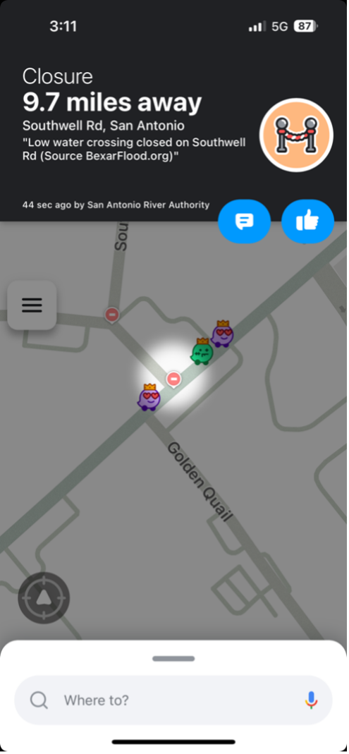
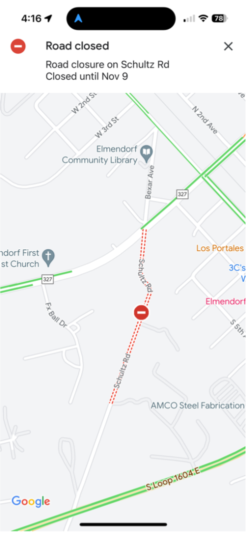
Examples of low water crossing notifications

Related Articles

Keep Wildlife Wild

What’s the wildest thing about the animals in the San Antonio River Basin? Well, they’re wildlife! Wildlife...

Alerts

Temporary Trail Closure Notice – Riverwalk area between the Hotel Emma & Brewmeister’s Bridge

Closure Dates: June 10 – August 5, 2025

As part of the Perlen Hotel (formerly Grove Hotel) project, the trail area between the Hotel Emma and Brewmeister Alle bridges will be temporarily closed for construction. This work includes modifications to the existing retaining wall and installation of a new second retaining wall.

Please follow the detour routes below to continue your walk or ride safely:

  • Southbound pedestrian traffic:
    Exit the river trail and use the Hotel Emma bridge to access the east side river trail via the elevator or stairs.
  • Northbound pedestrian traffic:
    Exit the river trail at the south bridge, access the east side river trail, and continue north through Pearl toward Hotel Emma. The river trail is accessible on both sides via the Hotel Emma bridge.

Thank you for your patience as we work to enhance this area of the trail.

Map of River Trail Closure

Parks Notice: Helton Nature Park

Due to a fallen tree containing an active beehive, the lower portion of the park is temporarily closed for safety. Our team is working with a specialist to safely remove the bees from the area. We’ll reopen this section of the park as soon as it’s safe to do so.

Thank you for your understanding and cooperation!

Trail Closure Notice – San Pedro Creek

Due to adjacent construction at Calder Alley, the San Pedro Creek Trail will be temporary closed from the access point near Stream at W. Commerce Street to Dolorosa Street. An alternate ADA-accessible route is available through UTSA San Pedro 1.


Graytown Park Parking Lot Construction Notice 

Construction Timeline: April – October 2025 (estimated)

Improvements are coming to Graytown Park! Parking lot construction will begin in April, and we appreciate your patience as we work to enhance the park for all visitors.

Temporary Closures & Impacts:

  • Upper parking area, pavilion, and restrooms will be CLOSED during construction. Temporary restroom facilities will be provided.
  • Park and river access will be CLOSED Monday–Friday from 8 AM – 5 PM (no access during these hours).

We encourage visitors to plan accordingly and check back for updates as the project progresses. Thank you for your support!

Stay Updated: Follow us on social media for the latest updates.

Trail Closure – San Pedro Creek Culture Park

* Trail temporarily closed from 5/1/2025 until 9/1/2025.

Due to adjacent construction work, the San Pedro Creek Trail on the west side of the creek will be closed from the access
point at W. Nueva Street to Dolorosa Street until further notice. Alternate route with ADA access is on the east side of the creekSan Pedro Creek Culture Park Trail Closure

SASPAMCO Paddling Trail

The SASPAMCO paddling trail is open from River Crossing Park to Helton Nature Park.
*Please Note: Paddling Trail from Helton Nature Park to HWY 97 is still closed due to blockages. 

SASPAMCO Paddling Trail Temporarily Closed

Staff have removed two large log jams just downstream of Helton Nature Park, keeping the southern portion of the SASPAMCO Paddling Trail temporarily closed. Staff are working to contact adjacent landowners to support a land-based removal solution.

Goliad Paddling Trail Alert

NOTICE: HWY 59 Landing Site Closed

Due to TxDOT construction on the HWY 59 Bridge, the HWY 59 landing site is closed until further notice. However, the Goliad Paddling Trail remains open, and paddlers can still access the river at the Riverdale, Ferry Street, and Goliad State Park landings.

Please plan accordingly and check back for updates.

River Reach Newsletter and Blog Signup

River Reach is offered as a printed, physical mailing to your residence or business. The Blog is a weekly electronic email with news and updates in order to be more environmentally conscious. Please fill out the form below and indicate your preferred method of delivery.

By submitting this form, you are consenting to receive marketing materials from: San Antonio River Authority, 100 East Guenther St., San Antonio, TX, 78204, US. You can revoke your consent to receive emails at any time by using the SafeUnsubscribe® link, found at the bottom of every email. Emails are serviced by Constant Contact. This site is protected by reCAPTCHA and the Google Privacy Policy and Terms of Service apply.