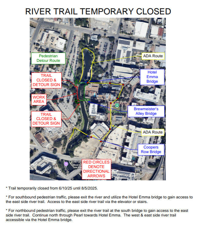
The San Antonio River Authority (River Authority) was created in 1937 by the State of Texas to preserve, protect, and manage the resources and environment of the San Antonio River Basin.
A 12-member Board of Directors governs the River Authority with six directors elected from Bexar County and two elected from Wilson, Karnes and Goliad counties. Each elected member serves six years. Policies established by the Board are executed by the management organization under the direction of a General Manager appointed by the Board.
The River Authority has the statutory authority to impose an ad valorem tax for use in planning, operations and maintenance activities only. Its tax is statutorily limited to two cents per $100 of assessed property valuation. The current ad valorem tax rate is set at $0.01858 per $100 assessed property valuation. The average annual tax is $40.20. The adopted FY 2020-2021 budget is $374.4 million.
Inspiring actions for healthy creeks and rivers.
Committed to safe, clean, and enjoyable creeks and rivers.
To harmonize the needs of people and nature through our stewardship of rivers and land.
Public safety through flood risk management is the River Authority’s priority. For more than 80 years, cities and counties in the River Authority’s District, as well as the Federal government, have relied on the River Authority’s engineering and technical expertise in flood management and risk reduction. With documented increases in the intensity and destruction of major storms, such as Hurricane Harvey, the most cost-effective way to prepare and respond to the impact of these storms is to ensure that hydraulic and hydrology information, rainfall data, land use changes, floodplain maps, watershed master plans, and capital improvement master plans stay current.
Serves as Cooperating Technical Partner and Letter of Map Revision delegate for the Federal Emergency Management Agency (FEMA) in order to locally update and maintain regulatory and non-regulatory floodplain maps throughout the River Authority’s four-county district. Providing the most up-to-date and dynamic floodplain maps and flood risk products will help individuals understand their level of flood risk.
Creates and maintains watershed master plans for the San Antonio River Basin that identify areas of flood risk, water quality concerns, and green space opportunities. This critical information is intended for use by citizens and community leaders to guide investments in capital projects to mitigate flooding, inform future development decisions to help improve water quality in creeks and rivers, and ensure the health, recreational, and economic benefits of green space can be maximized.
Improving the health of creeks and rivers is the River Authority’s purpose. Since the 1970s, the River Authority’s scientific leadership and targeted efforts have resulted in reducing pollution and trash in our waterways and improving water quality throughout the basin. The River Authority’s work to mitigate future threats to our waterways is more critical than ever as communities within the basin are growing rapidly. In a region whose history and culture is linked to its natural resources, protecting our creeks and rivers as we grow demonstrates stewardship for these vital resources.
Enhancing appreciation and stewardship through recreation is the River Authority’s goal. The quality of life and health of citizens who live in the River Authority’s District can be improved through having recreational access along creeks and rivers. Over the past decade, the River Authority has added nature-based recreational activities throughout the basin including hike and bike trails, paddling trails, picnic and camping areas, playgrounds, fishing, birdwatching, and even disc golf courses. With more access, people can develop a greater appreciation for the natural resources and quality of life benefits provided by the San Antonio River and its tributaries.