Última actualización el 30 de enero de 2024
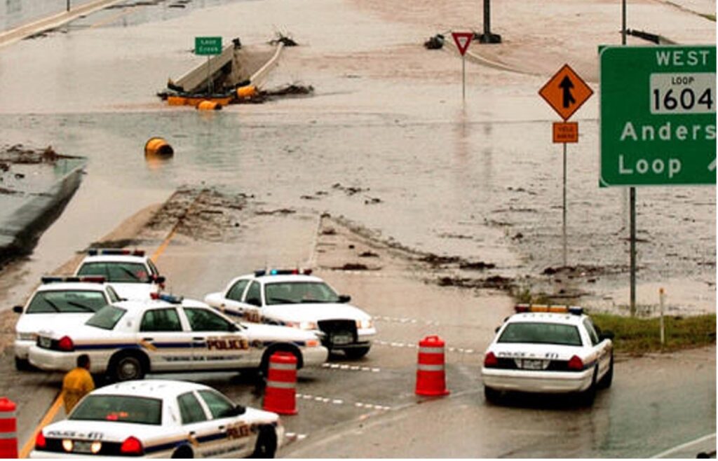
Dentro de la Cuenca del río San Antonio, la ciudad de San Antonio y el condado de Bexar tienen una Larga historia de inundaciones, en particular inundaciones repentinas. Como parte de Callejón de inundaciones repentinasEsta gran área metropolitana es una de las regiones más propensas a inundaciones en América del Norte. Esto se debe a varios factores, entre ellos la geografía, el clima y la urbanización. El resultado son aguas de inundación profundas, rápidas y erosivas que pueden afectar potencialmente a las comunidades río abajo, amenazando vidas y propiedades en toda la cuenca, particularmente en el condado de Bexar, donde urbanización pueden aumentar la escorrentía hasta seis veces más de lo que ocurriría en áreas naturales. Estos eventos de inundaciones repentinas pueden ocurrir en cuestión de minutos o unas horas después de un evento de lluvias intensas y, desafortunadamente, han incluido muertesDe hecho, las inundaciones y las crecidas repentinas son algunas de las Los eventos climáticos más fatales en los EE. UU..
Gestión de inundaciones y reducción de riesgos
Seguridad pública a través de gestión del riesgo de inundaciones es una prioridad máxima para la Autoridad del Río San Antonio. Con aumentos documentados en la intensidad y la destrucción de las grandes tormentas, como los huracanes Harvey e Ian, la forma más rentable de prepararse y responder al impacto de estas tormentas es garantizar que la información hidráulica e hidrológica, los datos de precipitaciones, los cambios en el uso de la tierra, los mapas de llanuras aluviales, los planes maestros de cuencas hidrográficas y los planes maestros de mejoras de capital se mantengan actualizados. La Autoridad del Río trabaja con varias autoridades locales, del condado y federales. colaboradores del gobierno Para que la cuenca del río San Antonio sea más segura frente a las inundaciones, lo hacemos utilizando conocimientos científicos y de ingeniería para desarrollar datos que respalden otras decisiones de financiación comunitaria relacionadas con el desarrollo y la implementación de proyectos de mitigación de inundaciones. Durante 85 años, desde la creación de la Autoridad del Río en 1937, las ciudades y los condados de nuestro Distrito y el gobierno federal han confiado en nuestra experiencia técnica y de ingeniería para gestión de inundaciones y reducción de riesgos.
La Autoridad del Río administra y opera 41 presas de retención de aguas de inundación en toda la cuenca del río San Antonio, incluida esta en el este del condado de Bexar. Las represas están diseñadas para redirigir y gestionar el flujo de agua, desviándolo para que no inunde los vecindarios donde hay una gran densidad de personas y propiedades.
Aumente su coeficiente intelectual sobre el riesgo de inundaciones con los recursos de River Authority
- BexarFlood.org, un sitio financiado por el condado de Bexar y operado por la Autoridad del Río, muestra las condiciones de las carreteras de los cruces de aguas bajas monitoreados en todo el condado de Bexar. Al suscribirse a las alertas a través de este sitio web, puede recibir alertas por mensaje de texto o correo electrónico cuando los cruces de aguas bajas que elija monitorear tengan agua sobre la carretera.
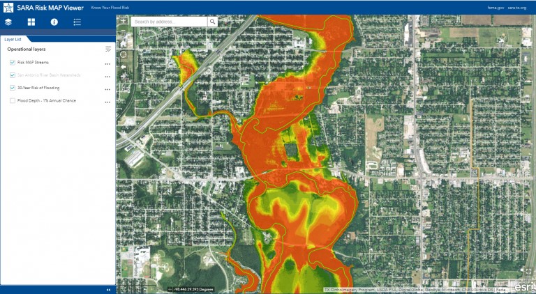
- Echa un vistazo a la Autoridad del Río Visor de llanuras aluviales y MAPA de riesgos Visualizador de datos de inundaciones, que permite al propietario de una propiedad determinar el nivel de riesgo de inundación durante la vigencia de la hipoteca a 30 años. La Autoridad del Río ha invertido recursos considerables en el desarrollo de mapas de llanuras aluviales actualizados en los condados de Bexar, Wilson, Karnes y Goliad. Esta inversión, combinada con nuestra experiencia, ha producido algunos de los mapas de llanuras aluviales de mayor calidad en los Estados Unidos.
- Pon a prueba tus conocimientos sobre el riesgo de inundaciones tomando nuestro examen sorpresa!
- Solicite una presentación comunitaria para obtener más información sobre los esfuerzos de la Autoridad del Río para mantener nuestras comunidades seguras.
¿Debería contratar un seguro contra inundaciones?
Según FEMA, existe cierto nivel de riesgo de inundación, sin importar dónde viva o trabaje. De hecho, aproximadamente el 25% de todas las reclamaciones de seguro contra inundaciones provienen de áreas con un riesgo mínimo de inundación. Por lo tanto, la Autoridad del Río apoya la recomendación de FEMA para que los propietarios de viviendas participen en el programa. Programa Nacional de Seguro contra Inundaciones Incluso si su compañía hipotecaria no les exige que tengan un seguro contra inundaciones.La Autoridad del Río ha incluido una calificación para la participación de la comunidad en el seguro contra inundaciones. Boletín de calificaciones de la cuenca del río San Antonio, y lamentablemente, la calificación de esta métrica es F, lo que indica una cantidad significativa de propiedades sin seguro en toda la cuenca. Visite nuestro sitio web para obtener más información sobre Obtener un seguro contra inundacionesJuntos, todos podemos hacer nuestra parte para que la seguridad sea una prioridad.
¡El alcance del río ha vuelto!
Alcance del río es un boletín trimestral de 12 páginas diseñado para informar a los electores de la Autoridad del Río San Antonio sobre los numerosos proyectos de la agencia, servir como vehículo de comunicación para la junta directiva y fomentar un sentido de unidad e identidad entre los residentes de Bexar, Wilson. , Karnes y Goliad.
Si desea ser incluido en la lista de correo de Alcance del río, por favor Contáctenos o Complete el formulario.