El Cuenca del río San Antonio tiene un largo historia de inundaciones eso ha dado forma a la forma en que las comunidades se preparan para futuras inundaciones. En la cuenca del río San Antonio, particularmente en los condados de Bexar, Medina, Comal y Guadalupe, el terreno empinado, los suelos poco profundos y los canales estrechos de arroyos y ríos envían la escorrentía rápidamente cuesta abajo. El resultado son inundaciones profundas, rápidas y erosivas en una región conocida como Callejón de inundaciones repentinas. Estas fuerzas destructivas tienen el potencial de impactar a las comunidades río abajo, amenazando vidas y propiedades en toda la cuenca.
Siga leyendo mientras conmemoramos los 100th aniversario de la Gran Inundación del 21 y comparta herramientas de la Autoridad del Río San Antonio (Autoridad del Río) que están disponibles para ayudarlo a prepararse y proteger su vida y propiedad de las inundaciones.
Gran inundación del 21
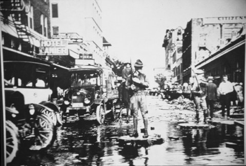
El 9 de septiembre de 1921, una tormenta creada a partir de los restos de un huracán atravesó el centro de Texas y produjo más de 7 pulgadas de lluvia en el centro de San Antonio y el lado oeste cercano de la ciudad. Al norte del centro de la ciudad, en el área de Olmos Creek, se registraron hasta 14 pulgadas de lluvia, las cuales drenaron en el río San Antonio y fluyeron hacia el sur a través del centro de la ciudad. La gran cantidad de lluvia en las comunidades del centro y del lado oeste, combinada con la enorme oleada de agua del norte, resultó en una inundación devastadora en el río San Antonio y sus afluentes al oeste del centro de la ciudad.
Los daños ascendieron a $3,7 millones (más de $56 millones en 2021). El número oficial de muertos contabilizó 51 personas que fallecieron durante la inundación, y la mayoría de las muertes ocurrieron a lo largo de los arroyos San Pedro y Alazán. Lamentablemente, se cree que otras personas se perdieron en la tormenta y no fueron reportadas a los funcionarios que contaron las cifras finales de muertes. La respuesta de la comunidad a esta trágica inundación cambió drásticamente la forma en que la ciudad manejó las inundaciones y esas soluciones de ingeniería todavía están impactando a San Antonio hoy, 100 años después de la devastación provocada por la inundación de septiembre de 1921.
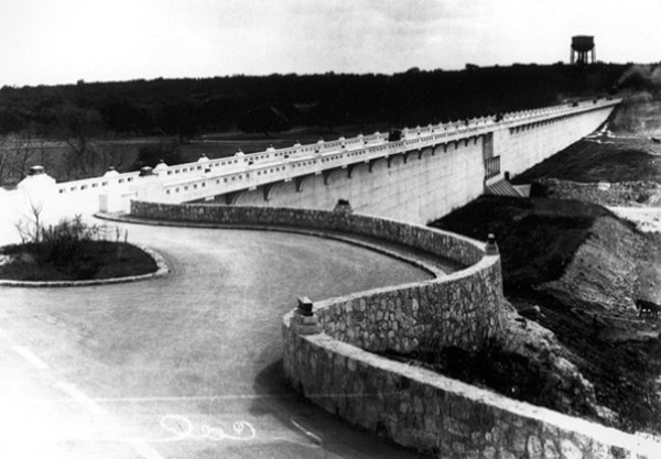
En 1924 se inició la construcción del Presa Olmos al norte del centro de la ciudad. La presa de $1,5 millones (casi $24 millones en 2021) se completó en 1926. Además de construir la presa de Olmos, entre 1924 y 1929, la ciudad gastó casi $4 millones (cerca de $64 millones en 2021) para limpiar y enderezar muchas secciones del río San Antonio desde Josephine Street al norte del centro de la ciudad, que hoy es parte del Alcance del museo cerca de Pearl, al sur del centro de la ciudad donde se unen el río San Antonio y el arroyo San Pedro, que hoy forma parte del Alcance de la misión cerca Parque de la Confluencia. Partes de los arroyos Alazán y San Pedro también fueron canalizados en la década de 1920, y estas áreas ahora son parte del Proyecto de restauración de Westside Creek, que se incluyó recientemente en el presupuesto del presidente. El canal de corte de Great Bend en el centro de la ciudad se inició en 1926 y se completó en 1930, y existe una historia fascinante sobre cómo se propuso y apoyó el famoso River Walk de San Antonio durante este período. Para los aficionados a la historia que quieran saber más, el libro fundamental de Lewis Fisher Venecia americana La historia épica del río San Antonio Capta con gran detalle la devastadora inundación de 1921 y el River Walk que nació de este trágico evento.
La Autoridad del Río aún no estaba creada cuando todo este trabajo se llevó a cabo en San Antonio. Fuimos creados por la Legislatura de Texas en 1936. Sin embargo, nuestra creación está ligada a la inundación de 1921 (y a las inundaciones de 1913 y 1914), ya que la gran tormenta de 1921 afectó grandes extensiones de Texas, incluidas Austin y Taylor, que establecieron un récord en EE. UU. cantidad de lluvia en 24 horas con más de 23 pulgadas de lluvia (ese récord de lluvia se ha batido desde entonces). Como resultado de esta horrible inundación, la Legislatura de Texas creó autoridades fluviales en todo el estado a partir de finales de la década de 1920 y durante toda la década de 1930. Estos nuevos distritos especiales, incluido el Canal del Río San Antonio y el Distrito de Conservación, como nos llamaron originalmente, estaban encargados de mitigar los daños por inundaciones en los ríos de Texas, entre muchas otras tareas.
¿Cómo puedo aprender más sobre mi propio riesgo de inundación?
Durante casi 85 años, desde nuestra creación en 1937, las ciudades y condados del Distrito de la Autoridad del Río, así como el gobierno federal, han confiado en nuestra experiencia técnica y de ingeniería en la gestión de inundaciones y la reducción de riesgos. Con aumentos documentados en la intensidad y destrucción de tormentas importantes, como el huracán Harvey, la forma más rentable de prepararse y responder al impacto de estas tormentas es garantizar que la información hidráulica e hidrológica, los datos de precipitaciones, los cambios en el uso de la tierra, las llanuras aluviales Los mapas, los planes maestros de cuencas hidrográficas y los planes maestros de mejoras de capital se mantienen actualizados.
La Autoridad del Río ha invertido recursos considerables en el desarrollo de mapas actualizados de llanuras aluviales en los condados de Bexar, Wilson, Karnes y Goliad. Esta inversión, combinada con nuestra experiencia, ha producido algunos de los mapas de llanuras aluviales de mayor calidad en los Estados Unidos. Visita nuestro sitio web para evaluar el riesgo de inundación de su hogar observando el Visor de mapas de riesgo y el Visor de llanuras aluviales de River Authority. La herramienta Risk MAP se puede utilizar para ayudarle a evaluar su nivel de riesgo de inundación, incluida información como el nivel de riesgo durante la vida de una hipoteca a 30 años. El Visor de llanuras aluviales lo ayudará a determinar si su propiedad se encuentra en la llanura aluvial con una probabilidad anual del 1 por ciento. Si su propiedad se encuentra en la llanura aluvial con una probabilidad anual del 1 por ciento (que también se conoce como inundación base o llanura aluvial de 100 años), es posible que deba obtener un seguro contra inundaciones.
La Autoridad del Río ha incluido una calificación para la participación del seguro comunitario contra inundaciones en el Boletín de calificaciones de la cuenca del río San Antonio, y desafortunadamente, la calificación para esta métrica es F, lo que indica una cantidad significativa de propiedades no aseguradas en toda la cuenca. Según la Agencia Federal para el Manejo de Emergencias (FEMA), existe cierto nivel de riesgo de inundación sin importar dónde viva o trabaje. De hecho, alrededor de 25% de todas las reclamaciones de seguros contra inundaciones provienen de áreas con riesgo mínimo de inundación. Por lo tanto, la Autoridad del Río apoya la recomendación de FEMA para que los propietarios de viviendas participen en el Programa Nacional de Seguro contra Inundaciones incluso si su compañía hipotecaria no le exige tener un seguro contra inundaciones.
BexarFlood.org es otra herramienta pública que muestra las condiciones de las carreteras de los cruces de aguas bajas monitoreados en todo el condado de Bexar. Al suscribirse a alertas a través de este sitio web, puede recibir alertas por mensaje de texto o correo electrónico cuando los cruces con nivel bajo de agua que elija monitorear tengan agua sobre la carretera. Si ve agua sobre la carretera, dé la vuelta y busque una ruta diferente.
Obtenga más información sobre las muchas otras formas en que River Authority ayuda a proteger las comunidades a las que servimos en nuestro Mitigación del riesgo de inundaciones página.