Última actualización el 30 de enero de 2024
como el Autoridad En cuanto a la seguridad contra inundaciones, la máxima prioridad para la Autoridad del Río San Antonio (Autoridad del Río) es la seguridad pública a través de gestión del riesgo de inundaciones. Con aumentos documentados en la intensidad y destrucción de las grandes tormentas, incluidos los huracanes Harvey e Ian, la forma más rentable de prepararse y responder al impacto de estas tormentas es garantizar que la información hidráulica e hidrológica, los datos de precipitaciones, los cambios en el uso de la tierra, Los mapas de llanuras aluviales, los planes maestros de cuencas hidrográficas y los planes maestros de mejoras de capital se mantienen actualizados.
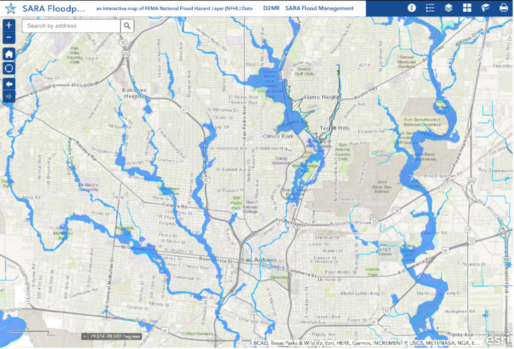
En ese esfuerzo, la Autoridad del Río está actualizando mapas de llanuras aluviales en coordinación con la Agencia Federal para el Manejo de Emergencias (FEMA) incorporar nuevos datos que afectan a todo el condado de Bexar, situado en el Cuenca del río San Antonio. Los individuos y las comunidades utilizan mapas de llanuras aluviales como herramientas para saber qué áreas tendrán mayores posibilidades de sufrir inundaciones.
¿Qué es una llanura aluvial y cómo me afecta?
FEMA define una llanura aluvial como cualquier área de tierra susceptible de ser inundada por aguas de cualquier fuente. Las llanuras aluviales legalmente definidas que designa FEMA se utilizan para fijar las tarifas del seguro contra inundaciones, y los emisores de hipotecas generalmente exigen un seguro contra inundaciones para cualquier propiedad en la llanura aluvial. Las ciudades también establecen normas de construcción especiales para propiedades dentro de llanuras aluviales. Lo más importante es que se utilizan modelos basados en llanuras aluviales para advertir a los ciudadanos de toda la cuenca sobre inundaciones inminentes.
Manténgase al tanto de la llanura aluvial actual con la información de la Autoridad del Río Visor de llanuras aluviales.
¿Qué datos se han utilizado históricamente en estos mapas?
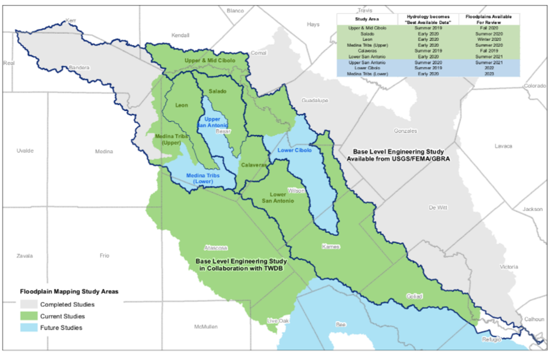
El último estudio de las llanuras aluviales en el condado de Bexar utilizó datos del terreno y del uso de la tierra de alrededor de 2004 y estimaciones de precipitaciones basadas en datos de la década de 1960. Estos eran los mejores datos disponibles en ese momento. Desde entonces, se ha actualizado suficiente información y datos para justificar una actualización de los mapas de llanuras aluviales.
¿Qué datos se están incorporando ahora?
La información actualizada incluye:
- las estimaciones de la Administración Nacional Oceánica y Atmosférica (NOAA) sobre cuánta lluvia caerá en grandes tormentas,
- datos de elevación de la superficie del terreno del Sistema de Información de Recursos Naturales de Texas (TNRIS) y
- los datos de uso de la tierra de la Autoridad del Río.
Estos aportes para el nuevo estudio de mapeo de llanuras aluviales se desarrollaron y recopilaron entre 2017 y 2019, y los estudios de ingeniería para desarrollar los borradores de las llanuras aluviales se han estado realizando desde 2019. Como puede ver, mantener a las personas y las propiedades a salvo de las inundaciones requiere diligencia, cooperación y tiempo. . Más, Debido a la naturaleza en constante cambio de las llanuras aluviales, es importante mantener los mapas regulatorios de llanuras aluviales lo más actualizados posible.
Las asociaciones son clave
La Autoridad del Río trabaja con varias autoridades locales, del condado y federales. socios gubernamentales para hacer que la cuenca del río San Antonio esté más segura frente a las inundaciones. La Autoridad del Río tiene acuerdos interlocales con el condado de Bexar, la ciudad de San Antonio y 19 ciudades suburbanas dentro del condado de Bexar para mantener los mapas de llanuras aluviales para sus jurisdicciones. La River Authority también es socio técnico cooperante de FEMA. A través de esta asociación, FEMA reconoce el papel crucial de la Autoridad del Río en el mapeo de llanuras aluviales, realizado en nombre de las comunidades locales.
¿Cómo se mantienen estos mapas?
Día a día, los mapas de llanuras aluviales se mantienen a través de Cartas de revisión de mapas. Las cartas de revisión de mapas son actualizaciones de mapas de llanuras aluviales a pequeña escala y generalmente cubren áreas pequeñas como lotes o vecindarios individuales. Estas revisiones generalmente reflejan cambios en la llanura aluvial. que resulten de la actividad constructora. Con menos frecuencia, se necesitan actualizaciones generalizadas que abarquen todo un condado para mantener actualizados los datos cartográficos de las llanuras aluviales.
¿Cuándo entrarán en vigor estos mapas?
La Autoridad del Río estima que los nuevos mapas de llanuras aluviales entrarán en vigor formalmente en 18 a 24 meses. La Autoridad del Río proporciona borradores de llanuras aluviales a FEMA, y FEMA continúa formalizando los paneles del mapa de llanuras aluviales. FEMA emitirá mapas preliminares de tarifas de seguros contra inundaciones (FIRMS) y luego le dará al público un período de apelaciones y comentarios de 90 días. Los FIRMS efectivos se publicarán después de que se revisen e incorporen las respuestas.
Los datos de ingeniería estarán disponibles de inmediato en el sitio web de la Autoridad del Río. Sitio web del Repositorio de modelado y datos digitales (D2MR) para su uso como "Mejores datos disponibles". El sitio web D2MR es una herramienta muy conocida utilizada en la comunidad de ingeniería de desarrollo.
¿Cuándo podrá el público ver los mapas?
La Autoridad del Río es iniciar el proceso de participación pública temprano Proporcionar a la comunidad tiempo suficiente para revisar y proporcionar comentarios sobre los mapas. A partir de enero de 2023, se llevarán a cabo jornadas de puertas abiertas para brindar a los miembros de la comunidad la oportunidad de buscar cualquier propiedad de interés dentro del condado en el mapa preliminar junto con un ingeniero de la Autoridad del Río. Además, el personal de la Ciudad y otras agencias gubernamentales estarán disponibles para responder preguntas sobre seguros contra inundaciones, regulaciones de llanuras aluviales y proyectos futuros o potenciales relacionados con inundaciones/drenaje en el área. Dirígete a nuestro sitio web para fechas y lugares de puertas abiertas.
¿Qué significa esto para los residentes y propietarios de negocios dentro y alrededor de las llanuras aluviales actualizadas?
El condado de Bexar y todas las ciudades del condado de Bexar tienen regulaciones especiales para las actividades dentro de la llanura aluvial para reducir el riesgo de inundaciones para la vida y la propiedad. Los residentes y propietarios de negocios deben coordinar con el administrador de la llanura aluvial de su jurisdicción para obtener un permiso de construcción o mejoras de edificios..
Si actualmente tiene una hipoteca respaldada por el gobierno federal sobre una propiedad en la llanura aluvial, se le pedirá que comprar seguro contra inundaciones. Según los datos del Programa Nacional de Seguro contra Inundaciones del 31 de agosto de 2022, el costo anual promedio de las primas del seguro contra inundaciones y las tarifas asociadas en el condado de Bexar es $783.45. La cobertura media, incluyendo edificio y contenidos, es $285,505.
Para obtener más información sobre el seguro contra inundaciones, los propietarios pueden hablar con su proveedor de seguro de hogar, teniendo en cuenta que El seguro contra inundaciones es independiente del seguro de hogar.. También puede visitar los siguientes sitios web:
Juntos, todos podemos hacer nuestra parte para hacer de la seguridad una prioridad.
Regístrate en River Reach
Alcance del río es un boletín trimestral de 12 páginas diseñado para informar a los electores de la Autoridad del Río San Antonio sobre los numerosos proyectos de la agencia, servir como vehículo de comunicación para la junta directiva y fomentar un sentido de unidad e identidad entre los residentes de Bexar, Wilson. , Karnes y Goliad.
Si desea ser incluido en la lista de correo de Alcance del río, por favor Contáctenos o Complete el formulario.